Chile Wine Map Maker: Build Custom Maps in 2D and 3D
Profile the Andes-to-Pacific elevation drop, simulate sunlight across the Central Valley, annotate DO boundaries. This isn’t a map you look at, it’s one you build.
The Chile Map Maker is an interactive GIS workspace built on SommGeo’s Chilean DO layers: the six viticultural regions from Atacama to Austral on one layer and the 25 valleys and zones inside them, Maipo, Colchagua, Apalta, Casablanca, Leyda, Itata and the rest, on another, each with its boundary and profile. Load a region or a single valley from the legend, choose a basemap, switch between 2D and 3D, run an elevation profile from the Andes to the coast, set the daylight simulator, sketch and label on top, then save the view as an image. The interactive map is part of SommGeo membership, which starts with a free 15-day trial.
- Regions on the map: Six DO viticultural regions (Atacama, Coquimbo, Aconcagua, Central Valley, Sur, Austral) and 25 DO valleys and zones, 31 boundaries in all
- Layers: Overarching regions and the valleys and zones as separate fills, with bright and dark outline and white-label versions for clean exports, all with adjustable transparency
- Tools: 2D and 3D views, basemap gallery, measure and elevation profile, daylight simulator, sketch and label (2D only), save as image
- Export: Save captures the current view as a downloadable image; untick “Include Legend” for a clean map
- Profiles: Every region and valley opens a popup with its grapes, climate and soils; where a valley sits inside a region, arrows in the popup header step through both
- Length: DO vineyards from about 27°S in the Copiapó Valley to past 40°S at Osorno, some 1,500 km (950 miles) along a corridor rarely more than 200 km (125 miles) wide
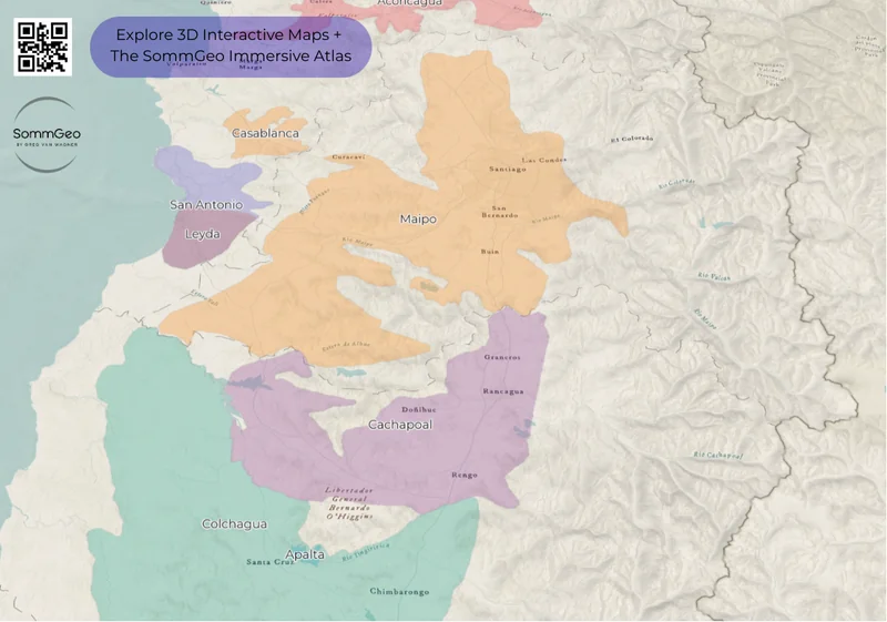
The Chile Map Maker puts a professional GIS toolkit in your hands. Every Chilean Denomination of Origin (from the desert frontier of Atacama to the ancient bush vines of the Sur) is here with full boundary data, satellite imagery, and analysis tools that go far beyond a standard wine map. Chile’s viticultural story runs along a narrow corridor between the Andes and the Pacific, and a flat map does none of it justice. Switch between 2D and 3D to understand why the Coastal Range creates radically different conditions on either side. Run an elevation profile from the Andes foothills down to the coast to see the altitude dynamics behind Chile’s Costa, Entre Cordilleras, and Andes transversal zones. Simulate daylight to see how afternoon shadow from the Andes affects specific vineyard sites. Or use the Sketch tools to annotate, label, and save a custom view for a presentation, class, or buying trip. And every mapped region includes detailed popup content covering grape varieties, climate profiles, soil types, viticulture, a sommelier-level reference built directly into the map.
Unlock the Full SommGeo Toolkit
Gain exclusive access to our entire suite of premium features, including interactive Map Makers, immersive 3D Tours, high-resolution classic Maps, and advanced analytical tools.
Start Free TrialFree to study. Credit when you share it.
Use the map for your own study and tastings. If you share or teach with it, credit it visibly as Map: SommGeo (sommgeo.com). Commercial use requires a license.
See Map Usage, Credit and Licensing for the full terms and the Commercial Embed License.
What You Can Build
Unlike a static wine map, the Chile Map Maker is a full interactive workspace, and the real depth is in what each region reveals. Click on any mapped DO and a comprehensive info panel opens with sommelier-level content: grape variety breakdowns, climate and geographic profiles, soil composition, the viticultural specifics that define each denomination. Whether you’re reading about the Humboldt Current’s cooling influence on Leyda’s coastal Sauvignon Blanc, the alluvial gravels of Maipo Alto, or Itata’s ancient País bush vines on granite, every mapped region carries this level of built-in intelligence. Beyond the content, every tool in the bottom toolbar opens a different way to interrogate Chilean wine geography, and you can save your custom views to revisit or share.
- In-depth region profiles: Click any mapped area for detailed content covering varieties, climate, soils
- 3D / 2D Toggle: Switch between flat overview and immersive 3D terrain to see how the Andes and Coastal Range create Chile’s narrow viticultural corridor
- Daylight Simulator: Set any date and time to model sun position and shadow cast across vineyard sites, essential for understanding Chile’s east-west aspect dynamics
- Measure Tool: Draw lines to measure distances and generate elevation profiles between any two points, from the Andes foothills to the Pacific coast
- Sketch & Annotate: Drop pins, draw shapes, and add text labels to build custom presentations directly on the map (2D only)
- Legend & Map Layers: Toggle DO region boundaries on and off, adjust layer transparency, and use Interactive Legend to load zones one at a time

Tools in Action
Each tool in the Map Maker pairs with a specific geographic story that’s hard to tell any other way. Here’s how wine professionals are using them with Chilean wine geography.
🏔️ Elevation Profile + Andes to Coast
Draw a line from the Andes foothills above Puente Alto across the Central Valley and over the Coastal Range to the Pacific near Casablanca. The Measure tool generates an elevation cross-section that makes Chile’s entire east-west viticultural logic click. You’ll see exactly why Andes-designated vineyards at 800+ meters (2,625+ ft) produce wines with intense UV concentration, while coastal sites sit in cool maritime fog at 200 meters (656 ft). The altitude drop across 100 kilometers (62 miles) changes everything.
☀️ Daylight Simulator + Maipo Valley
Set the Daylight tool to a late summer afternoon in the Maipo Valley and watch how the Andes cast long shadows across the valley floor as the sun drops west. This afternoon shadow effect is one reason Chile’s east-facing Andean sites ripen differently from the west-facing Coastal Range slopes; morning sun versus afternoon sun creates fundamentally different heat accumulation patterns. Compare January to July to see how dramatically the shadow geometry shifts with the seasons.
🌐 3D Mode + Casablanca & San Antonio
Chile’s cool-climate coastal valleys only make sense in 3D. Toggle to the 3D satellite view and zoom into Casablanca. You’ll see it’s a bowl-shaped depression that funnels cold Pacific air and morning fog directly inland from the coast. San Antonio and its star sub-zone Leyda sit even closer to the ocean. The 3D perspective shows why these sites produce Sauvignon Blanc and Chardonnay with a tension and salinity that the warm Central Valley floor simply cannot deliver.
✏️ Sketch + Staff Training Maps
Building a Chilean wine training for your team? Drop labeled pins on Puente Alto, Apalta, Peumo, Casablanca, and Leyda. Draw boundary highlights around the transversal Costa, Entre Cordilleras, and Andes zones. Add text annotations explaining why Carmenere thrives in Peumo’s clay soils but Cabernet dominates the gravel terraces of Alto Maipo. Save and export your annotated map as a downloadable image. It’s a finished visual aid without opening PowerPoint.
Chile’s Wine Geography
Understanding Chilean wine starts with understanding Chile’s shape. The country stretches over 4,300 kilometers (2,672 miles) north to south but averages only about 177 kilometers (110 miles) east to west. Vineyards occupy a roughly 1,400-kilometer stretch between the latitudes of 27° and 39° South. The Humboldt Current, a massive cold-water system running up the Pacific coast from Antarctica, functions as a natural air conditioner. Combine that with altitude effects from the Andes (which reach over 6,000 meters (19,685 ft) in places) and the rain shadow created by the Coastal Range, and you get a country with an almost absurd range of growing conditions packed into a narrow corridor.
The east-west dynamic is everything. In 2011, Chile’s Ministry of Agriculture formally recognized what winemakers had been saying for years by introducing three transversal designations that overlay the existing north-south DO system. Costa identifies vineyards under direct Pacific maritime influence: cool, fog-prone, ideal for Sauvignon Blanc, Chardonnay, and Pinot Noir. Entre Cordilleras covers the warm valley floor between the Coastal Range and the Andes, where the bulk of Chile’s Cabernet Sauvignon, Carmenere, and Merlot is grown. Andes designates high-elevation sites in the foothills, where intense UV radiation and massive diurnal temperature swings produce wines with remarkable concentration and freshness. The Map Maker’s elevation profile tool is the fastest way to see this three-lane system in action. Draw a line east to west through any major valley and the altitude logic becomes immediately clear.
Soils vary dramatically across this corridor. The Central Valley floor is dominated by alluvial deposits: gravel, sand, and clay carried down from the Andes by rivers over millennia. The best sites, like the famous gravel terraces of Puente Alto in Alto Maipo, are ancient alluvial benches with excellent drainage. The Coastal Range brings granitic and metamorphic soils, contributing minerality to wines from regions like Itata and parts of Maule. In the far north, the Limari Valley’s limestone-rich soils produce some of Chile’s most striking mineral-driven Chardonnays. And critically, Chile is one of the very few wine-producing countries in the world that has never been affected by phylloxera, meaning many vines grow ungrafted on their own roots, a distinction that old-vine advocates believe contributes to a purer expression of site.
Key Regions to Build
Maipo Valley: Chile’s Cabernet Heartland
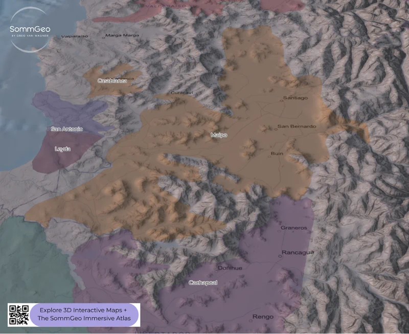
The Map Maker earns its keep in Maipo, where the concentration of Chile’s most iconic vineyards within a compact area rewards close inspection. Use the hillshade basemap to see how the Andes foothills create the entire framework for Alto Maipo, with the sub-zone of Puente Alto sitting on stony, well-drained alluvial terraces that produce Cabernet Sauvignon of genuine world-class quality. This is the home of Concha y Toro’s Don Melchor, Errazuriz’s Vinedo Chadwick, and Almaviva: structured, age-worthy wines that have consistently competed with top Bordeaux and Napa Cabernets in international blind tastings. The 2004 Berlin Tasting was the landmark moment when Vinedo Chadwick and Sena outscored Lafite and Margaux.
Below Puente Alto, the valley warms as it moves further from the Andes. Buin and Isla de Maipo offer different soil profiles and slightly less elevation, making them strong territory for Carmenere. Run the elevation profile tool from the Andes edge down through the valley floor and you’ll see the altitude gradient that defines each sub-zone’s character.
Rapel Valley: Cachapoal, Peumo & Colchagua
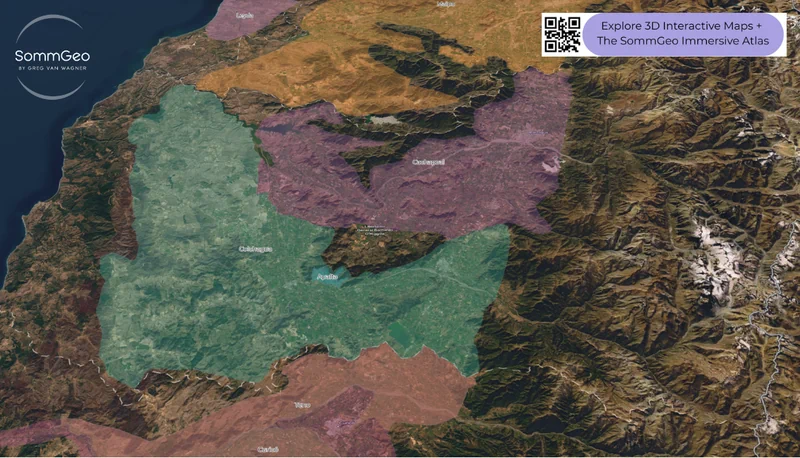
The Rapel Valley divides into two sub-regions that each tell a different story in 3D. Cachapoal includes the Peumo Valley, widely regarded as Chile’s finest site for Carmenere, where the Coastal Range wraps protectively around alluvial and colluvial soils over granite bedrock. Toggle to the 3D view and the encirclement is immediately visible. Concha y Toro recognized Peumo’s potential early, and today wines like Terrunyo Carmenere and Carmin de Peumo showcase what this specific site does best.
Colchagua, to the south, is bigger, warmer, and home to some of Chile’s most ambitious estates. The sub-valley of Apalta has become synonymous with premium Chilean reds; this is where Lapostolle’s Clos Apalta and Montes’ flagship wines originate. The satellite basemap shows Colchagua’s clay-dominated landscape and the emerging coastal plantings near the Pacific that are expanding what the region can do with cool-climate whites.
Casablanca & San Antonio: Cool-Climate Pioneers
Casablanca was Chile’s first purpose-planted cool-climate region, pioneered by Pablo Morande in 1982. The 3D satellite view reveals why: it’s a bowl-shaped depression that channels cold Pacific air and morning fog directly inland. The old granitic clay soils and extended growing season (sometimes a full month longer than the Central Valley) produce vibrant Sauvignon Blanc and Chardonnay with a mineral backbone that was essentially unknown in Chilean whites before Casablanca proved it could be done.
San Antonio and its star sub-zone Leyda push even closer to the ocean. Use the Daylight Simulator to see how persistent coastal cloud cover moderates temperatures here; the best Sauvignon Blancs from Leyda show a saline, almost crystalline character. Casa Marin, one of the appellation’s founding estates, helped prove Chile could compete well in cool-climate white production.
Maule, Itata & the Southern Revival
This is arguably the most exciting story in Chilean wine right now, and the Map Maker helps you understand why these regions were overlooked for so long, and why they shouldn’t have been. Maule and Itata are home to Chile’s oldest vineyards: dry-farmed, head-pruned bush vines of Pais, Cinsault, Carignan, and Muscat, some well over a century old, growing ungrafted on granitic soils in the Secano Interior. Zoom into the Coastal Range using the 3D view and you’ll see the rugged terrain where these ancient vineyards cling to hillsides far from the irrigated Central Valley floor.
For decades these vineyards were either ignored or relegated to bulk production. Nowadays, a wave of independent producers (Garage Wine Co., De Martino, Bouchon Family Wines) has transformed them into the source of Chile’s most authentically Chilean wines. The VIGNO collective, a trademark association of Carignan growers in Maule’s Secano, requires a minimum 65% Carignan from dry-farmed bush vines at least 30 years old, essentially Chile’s first grassroots appellation alternative. The Pais grape, once dismissed, has been revived by producers who recognized that century-old, ungrafted, own-rooted vines are a viticultural treasure that most of the world lost to phylloxera.
New to the Map Makers? Explore all the tools, tips, and features in our complete walkthrough.
Map Maker Guide →Regions and valleys you can build with (31)
Every region, valley and zone on the Map Maker, north to south, as drawn on the Chilean DO layers. Load any of them from the legend; each opens a full profile.
| Name | Official name | Principal grapes |
|---|---|---|
| Atacama | ||
| Atacama | Región Vitícola de Atacama DO | Sauvignon Blanc, Syrah |
| Copiapó | Valle de Copiapó DO | Moscatel, País |
| Huasco | Valle del Huasco DO | Chardonnay, Sauvignon Blanc, Syrah, Pinot Noir |
| Coquimbo | ||
| Coquimbo | Región Vitícola de Coquimbo DO | Chardonnay, Syrah |
| Elqui | Valle de Elqui DO | Syrah, Sauvignon Blanc |
| Limarí | Valle del Limarí DO | Chardonnay, Syrah |
| Choapa | Valle del Choapa DO | Syrah |
| Aconcagua | ||
| Aconcagua | Región Vitícola de Aconcagua DO | Cabernet Sauvignon, Syrah, Sauvignon Blanc, Chardonnay |
| Aconcagua | Valle de Aconcagua DO | Cabernet Sauvignon, Carmenère, Syrah, Sauvignon Blanc |
| Casablanca | Valle de Casablanca DO | Sauvignon Blanc, Chardonnay, Pinot Noir |
| San Antonio | Valle de San Antonio DO | Sauvignon Blanc, Pinot Noir, Syrah, Chardonnay |
| Leyda | Valle de Leyda DO | Sauvignon Blanc, Pinot Noir, Syrah |
| Central Valley | ||
| Central Valley | Valle Central DO | Cabernet Sauvignon, Carmenère |
| Maipo | Valle del Maipo DO | Cabernet Sauvignon |
| Cachapoal | Valle del Cachapoal DO | Carmenère |
| Colchagua | Valle de Colchagua DO | Cabernet Sauvignon, Carmenère, Syrah, Malbec |
| Apalta | Valle de Apalta DO | Carmenère, Cabernet Sauvignon |
| Curicó | Valle de Curicó DO | Sauvignon Blanc, Cabernet Sauvignon |
| Teno | Valle del Teno DO | Sauvignon Blanc, Cabernet Sauvignon |
| Lontué | Valle del Lontué DO | Carmenère, Merlot |
| Maule | Valle del Maule DO | País, Carignan, Cabernet Sauvignon, Merlot |
| Claro | Valle del Claro DO | Pinot Noir, Cabernet Sauvignon, Merlot, Carmenère |
| Loncomilla | Valle de Loncomilla DO | País, Carignan |
| Tutuvén | Valle de Tutuvén DO | Carignan, País, Cinsault |
| Sur | ||
| Sur | Región Vitícola del Sur DO | País, Cinsault, Riesling, Chardonnay |
| Itata | Valle del Itata DO | País, Muscat |
| Bío-Bío | Valle del Bío-Bío DO | País, Moscatel, Pinot Noir, Chardonnay |
| Malleco | Valle de Malleco DO | Chardonnay, Pinot Noir |
| Austral | ||
| Austral | Región Vitícola Austral DO | Pinot Noir, Chardonnay, Sauvignon Blanc |
| Cautín | Valle del Cautín DO | Chardonnay, Pinot Noir |
| Osorno | Valle de Osorno DO | Sauvignon Blanc, Pinot Noir, Chardonnay, Riesling |
Hopefully this index is useful on its own. To explore these regions interactively, with every boundary on real terrain and a full profile for each, start a 15-day free trial. To see what one of these maps is like first, a different map is unlocked for everyone every day. For a ready-made view of the same valleys, see the Chile Fast Map and the Chile 3D Fast Map; the Map Maker Guide walks through every tool.
Chile Map Maker: Frequently Asked Questions
How is the Map Maker different from the Chile Fast Map?
The Fast Map is finished: every region and valley drawn, every profile a click away. The Map Maker starts blank and gives you the same boundaries as layers, so you decide whether to show the six regions, the 25 valleys or one valley on its own, what basemap sits beneath, whether the view is flat or 3D and what you draw on top, then save the result as an image.
Can I show the six regions without the valleys?
Yes. The overarching layer carries only the six DO viticultural regions, Atacama, Coquimbo, Aconcagua, Central Valley, Sur and Austral, so a national view stays clean. The valleys and zones sit on their own layer, and the legend’s Interactive mode adds them one at a time, which is how to build the Central Valley from Maipo, Cachapoal, Colchagua and Apalta, Curicó with Teno and Lontué, and Maule with Claro, Loncomilla and Tutuvén.
Are Costa, Entre Cordilleras and Andes on the map?
Not as boundaries. Costa, Entre Cordilleras and Andes are complementary terms a DO wine can add to show which band of the valley its grapes come from, and the decree defines them by lists of communes rather than by drawn appellation limits, so the map carries the DO regions, valleys and zones. The terrain is where they show: draw an elevation profile west to east across Colchagua or Maipo and the Coastal Range, the central depression and the Andes foothills appear as three bands.
Can I download the map I build?
Yes. Save captures the current view, sketches and labels included, as an image you can drop into slides, a handout or a study sheet. Untick “Include Legend” for a cleaner export. Sketching works in 2D, so build annotated views flat and switch to 3D for terrain shots. The Map Maker Guide walks through each tool.
Is the Chile Map Maker free?
The region index on this page is free to use. The Map Maker itself, with its layers, tools and a full profile for every region, is part of SommGeo membership, which starts with a free 15-day trial. If you want a feel for what one of these maps is like before signing up, SommGeo unlocks one map every day on a rotation, different every day, no signup needed. Today’s unlocked map is on the home page.
Ready to build your own Chilean wine maps? Join 200+ wine organizations already using SommGeo.
Start Your 15-Day Free Trial $5/month billed annually after trial · Cancel anytimeMap by Greg Van Wagner, SommGeo
Please let us know what you think in the form below. Thanks!