Portugal Wine Map Maker: Build Your Own Interactive Map
Draw, measure, annotate, and explore Portugal’s 31 DOPs across 14 wine regions, from satellite views of the Douro’s terraced schist to 3D flybys of Madeira’s volcanic slopes.
The Portugal Map Maker puts the full toolkit in your hands. This isn’t a static reference or a pre-set guided tour. It’s an active workspace where you can switch between satellite imagery, topographic relief, and stylized basemaps to study every Portuguese wine DOP on your own terms. Use the measurement tools to ground-truth the geography; the Serra do Marão sits barely 60 kilometers from the Atlantic coast, but that distance explains almost everything about why the Douro tastes nothing like Vinho Verde. Toggle between 2D and 3D views to see how elevation, river valleys, and coastal exposure shape some of Europe’s most distinctive and undervalued wine regions. Whether you’re building study materials, preparing a presentation, or just want to understand why the Alentejo and the Douro make such fundamentally different wines from grapes growing barely 300 kilometers apart, this is the tool for it. Every mapped region includes detailed popup content covering grape varieties, climate profiles, soil types, and wine law, a sommelier-level reference built directly into the map.
Unlock the Full SommGeo Toolkit
Gain exclusive access to our entire suite of premium features, including interactive Map Makers, immersive 3D Tours, high-resolution classic Maps, and advanced analytical tools.
Start Free TrialWhat You’ll Explore
The Portugal Map Maker is an active workspace, but the real depth is in what each region reveals. Click on any mapped DOP and a comprehensive info panel opens with sommelier-level content: indigenous grape varieties, climate and geographic profiles, soil composition, wine law and classification details, the viticultural specifics that define each region. Whether you’re reading about the schist terraces of Cima Corgo and their role in premium Port, the granitic soils driving Vinho Verde’s mineral freshness, or the volcanic basalt shaping Madeira’s noble varieties, every mapped region carries this level of built-in intelligence. Beyond the content, you control the experience. Choosing basemaps, toggling DOP layers, measuring distances, adding placemarks, and switching between 2D and 3D terrain exploration.
- All 31 DOP/DOC boundaries across Portugal’s 14 regional wine areas with toggleable layers
- In-depth region profiles for every mapped area: varieties, wine law, soils, climate
- 40 basemaps: satellite imagery, topographic relief, hillshade, newspaper-style cartography, and more
- Measurement tools for calculating distances and areas between regions, vineyards, and landmarks
- Placemark and annotation tools for building custom study maps and presentation materials
Geography That Makes Portugal Unique
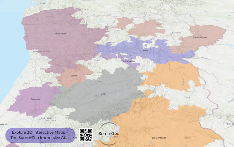
Portugal compresses an extraordinary range of viticultural environments into a country smaller than Indiana. The 3D views in this Map Maker make the geographic logic immediately visible: the Serra do Marão and Serra da Estrela mountain ranges act as climatic walls, creating a dramatic divide between the wet, Atlantic-influenced west and the hot, arid interior. West of the mountains, Vinho Verde receives upwards of 1,500mm (59.1 in) of annual rainfall and produces lean, high-acid whites from granitic soils. East of them, the Douro (the world’s first formally demarcated wine region (1756)) bakes through continental summers, its schist-terraced slopes yielding concentrated reds and the raw material for Port.
Further south, the Alentejo sprawls across a vast, gently rolling plain that covers nearly a third of Portugal’s landmass, and produces a similar proportion of its wine. This is serious cork country too, but the wines have increasingly demanded equal attention. The climate is relentlessly hot and dry in summer, with temperatures regularly exceeding 40°C (104°F) and annual rainfall that barely registers compared to the wet northwest. The soils are genuinely diverse: clay, schist, granite, marble, and limestone all appear across the region’s eight subregions, which matters more than it might seem in an area this large.
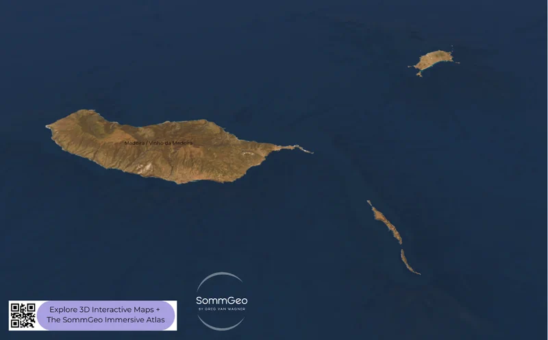
At the geographic extremes, Madeira sits roughly 1,000 kilometers (621 miles) southwest of Lisbon in the open Atlantic, a volcanic island where altitude and aspect determine everything. Use the 3D satellite view in the Map Maker to see just how extreme this terrain is: vineyard terraces carved into slopes so steep that harvesting by machine is impossible, with the four noble grape varieties (Sercial, Verdelho, Bual, and Malvasia) each gravitating to specific elevations and exposures. It’s one of the wine world’s great natural laboratories, and the 3D perspective makes you understand why these wines taste the way they do.
Sample Regions to Explore in the Map Maker
The Douro Valley & Port
Start here. Switch to 3D satellite view and fly east from the Serra do Marão into the valley. The transition from green, rain-soaked hillsides to the arid, terraced schist of the Douro is one of the most dramatic landscape shifts in European viticulture. The three sub-regions (Baixo Corgo, Cima Corgo, and Douro Superior) reveal themselves clearly in the topography: Baixo Corgo closest to the mountains and coolest, Cima Corgo at the heart of premium Port production around Pinhão, and the wide-open expanses of Douro Superior pushing toward Spain. Use the measurement tool to see just how compact this region is; the entire valley stretches only about 100 kilometers (62 miles), yet the climatic variation from west to east is enormous. Nowadays, the dry table wines from producers like Niepoort, Quinta do Crasto, and Quinta do Vale Meão are arguably the bigger story for sommeliers.
Vinho Verde
Vinho Verde occupies the entire northwest corner of Portugal; it’s Portugal’s largest appellation by area, which surprises people who associate the name with simple, inexpensive whites. Nine sub-regions reflect meaningful differences in soil, elevation, and maritime influence, and the Map Maker’s basemap options help visualize why. Monção e Melgaço, at the far northern edge along the Spanish border, sits sheltered in its own mesoclimate, producing the fuller-bodied Alvarinho that has earned international recognition. Compare that to the more Atlantic-exposed sub-regions like Lima and Cávado, where Loureiro dominates and the wines lean toward crisp, aromatic freshness. The granitic substrates that define this region are visible in the topographic view. Look for the low, rolling hills that distinguish it from the steep river gorges of the Douro to the south.
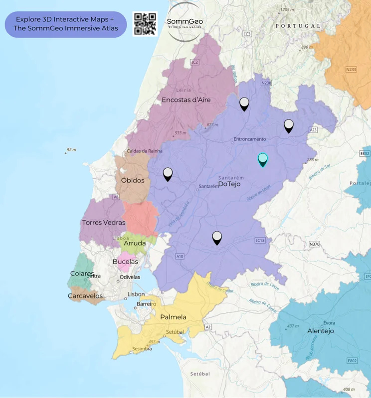
Lisboa & Its Historic DOPs
Zoom into the Lisbon area and use placemarks to tag the historic trio: Colares, Bucelas, and Carcavelos. These tiny appellations carry centuries of prestige but are being squeezed out of existence by urban sprawl. Colares is arguably the most remarkable, planted on deep sandy soils near the Atlantic at the foot of the Serra de Sintra, its ungrafted Ramisco vines survived phylloxera because the pest simply couldn’t navigate the sand. Fewer than 10,000 bottles are produced in most years. Bucelas, devoted almost exclusively to Arinto, makes mineral whites that were once among England’s most fashionable wines. Carcavelos, with fewer than 10 hectares (25 acres) surviving, produces a distinctive topaz-colored fortified wine that fewer people taste each year.
Alentejo & the South
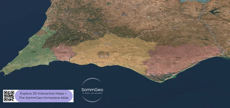
Switch to 3D view and pan south from Lisboa into the Alentejo’s rolling plains. The landscape flattens dramatically, and the soil colors shift from coastal limestone to the inland clay, granite, and schist that support Portugal’s most expansive wine region. Eight sub-regions make up the Alentejo DOC, and the Map Maker lets you explore how each relates to the broader geography. The heat here is real; summer temperatures regularly push past 40°C, and the grape varieties reflect it: Aragonez (Tinta Roriz), Trincadeira, and Alicante Bouschet dominate the reds, producing the full-bodied, fruit-forward wines the region is known for, while Antão Vaz leads a white wine lineup that punches above its weight in the right hands. Further south still, the Algarve’s four DOPs are worth exploring in satellite view. The Mediterranean influence is evident in the vegetation patterns visible from above.
New to the Map Makers? Explore all the tools, tips, and features in our complete walkthrough.
Map Maker Guide →Ready to build your own Portugal wine maps? Join 200+ wine organizations already using SommGeo.
Start Your 15-Day Free Trial $5/month billed annually after trial · Cancel anytimePlease let us know what you think in the form below. Thanks!

