Central Italy 3D Wine Map
Tuscany, Umbria, Le Marche, Abruzzo, Lazio, and Sardinia in full 3D terrain.
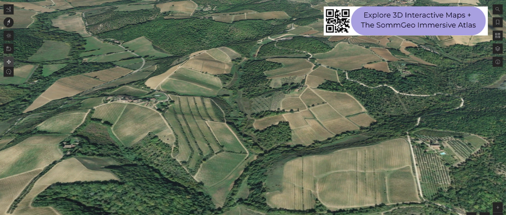
Central Italy is Sangiovese country, and the terrain tells the story. From the rolling hills of Chianti Classico to the isolated hilltop of Montalcino, from the coastal strip of Bolgheri to the Apennine foothills of Abruzzo, the geography shapes how this grape (and others) express themselves across a wide range of altitudes, aspects, and soil types. This map covers the DOC and DOCG zones of Central Italy with detailed popup data on each. The bookmarks are essential for navigating a map this rich: use them to fly between Tuscany, Umbria, Abruzzo, Le Marche, and other key areas.
Unlock the Full SommGeo Toolkit
Gain exclusive access to our entire suite of premium features, including interactive Map Makers, immersive 3D Tours, high-resolution classic Maps, and advanced analytical tools.
Start Free TrialWhat You’ll Explore
This 3D Fast Map covers the DOC and DOCG zones of Central Italy. Click any mapped appellation for detailed popup content covering grape varieties, classification details, and geographic specifics. Start with the bookmarks to fly between Tuscany’s key zones, Umbria, Abruzzo, and Le Marche.
- Central Italy’s DOC and DOCG zones mapped with detailed popup data
- Bookmarks to fly directly between Tuscany, Umbria, Abruzzo, Le Marche, and more
- Toggleable layers to control which regional groupings are displayed
- Elevation profile tool for measuring vineyard altitude and slope gradients
- Daylight and shadow animation to visualize aspect and sun exposure
- Weather overlay to see how Mediterranean and Apennine conditions interact with terrain
Key Regions in Focus
Tuscany: Chianti Classico, Montalcino, and the Coast
Tuscany is the heart of Central Italy’s wine identity. Chianti Classico occupies the hills between Florence and Siena at 250 to 600 meters (820 to 1,970 feet), where Sangiovese grows on galestro (friable marl) and alberese (hard limestone). The quality has never been higher, though Chianti remains varied. Montalcino, further south, is an isolated hilltop rising to 564 meters (1,850 feet) with a remarkable complexity of soils and microclimates that produce different expressions of Brunello depending on sector. On the coast, Bolgheri’s warm, maritime strip of clay and alluvial soils produces the Cabernet and Merlot blends that launched the Super-Tuscan movement. The bookmarks fly you between these areas to compare the terrain.
Umbria, Le Marche, and Abruzzo
East of Tuscany, the Apennine spine shapes viticulture in fundamentally different ways. Umbria’s Montefalco, with DOCG vineyards ranging from 220 to just over 470 meters (720 to 1,550 feet) on limestone and clay, is the home of Sagrantino, one of Italy’s most tannic and structured reds. Orvieto, in western Umbria, produces lighter whites from Grechetto and Procanico on volcanic tufa. The Marche contributes Verdicchio dei Castelli di Jesi (grown on calcareous clay hillsides in an amphitheater-like setting) and Conero (Montepulciano on the slopes of Monte Conero near the Adriatic). Abruzzo, along the eastern flank of the Apennines, is Montepulciano d’Abruzzo territory, where vineyards range from coastal plains to hillsides at 300 to 500 meters (985 to 1,640 feet). The elevation profiles across these regions reveal how altitude and the Apennine rain shadow create different growing conditions on opposite sides of the mountains.
Sardinia
Sardinia brings a completely different character to the map. Granite and schist soils, fierce wind exposure, and intense sun produce wines with real concentration. Cannonau (Grenache) dominates the reds, reaching its most site-specific expressions in the hillsides of Jerzu and the Ogliastra coast. Vermentino di Gallura, in the granite-strewn north, is Italy’s only Vermentino DOCG and produces whites with notable acidity and saline character. In 3D, Sardinia’s rugged interior and narrow coastal vineyard strips contrast sharply with the rolling Tuscan hills. Use the bookmarks to jump between the island and the mainland.
New to 3D Fast Maps? Learn how to navigate 3D terrain, use elevation profiles, animate sunlight, and get the most from your map.
3D Fast Maps Guide →Ready to explore Central Italy’s wine regions in full 3D? Join 200+ wine organizations already using SommGeo.
Start Your 15-Day Free Trial $5/month billed annually after trial · Cancel anytimeMap Usage & Permissions
Personal Use
You are welcome to use, download, and share the maps on this site for personal, educational, and non-commercial purposes. If you share a map, please credit SommGeo with a link back to sommgeo.com.
Commercial Use
Use of these maps for any commercial purpose, including websites, print publications, marketing materials, or any other commercial venture, is strictly prohibited without prior written permission.
To inquire about custom SommGeo platforms, maps, or commercial licensing, please contact greg@sommgeo.com.

