
Burgundy, Jura & Savoie 3D Wine Map
The Côte d’Or, Beaujolais crus, Chablis, and the Alpine appellations of Jura and Savoie in full 3D terrain.
This 3D Fast Map covers eastern France from the Kimmeridgian limestone of Chablis in the north through the Côte d’Or and Côte Chalonnaise, south into the granite hills of Beaujolais, and east into the pre-Alpine appellations of Jura and Savoie. In Burgundy, where the difference between a Grand Cru and a village wine can come down to a few meters of slope position, 3D terrain adds a dimension that flat maps simply cannot convey. The eastern aspect of the Côte d’Or, the volcanic peak of Brouilly, the Jura’s folded ridges, and the Alpine valleys of Savoie are all visible in the landscape here.
Unlock the Full SommGeo Toolkit
Gain exclusive access to our entire suite of premium features, including interactive Map Makers, immersive 3D Tours, high-resolution classic Maps, and advanced analytical tools.
Start Free TrialWhat You’ll Explore
This 3D Fast Map covers Burgundy (including Beaujolais), Jura, and Savoie. Click any mapped appellation for detailed popup content covering grape varieties, classification details, and geographic specifics. Use the bookmarks to jump between key areas and the layer controls to toggle different appellation groupings.
- Full 3D terrain from Chablis through the Côte d’Or to Beaujolais, Jura, and Savoie
- Bookmarks for quick navigation to key areas within the map
- Toggleable layers to control which appellation groupings are displayed
- Elevation profile tool for measuring vineyard altitude and slope gradients
- Daylight and shadow animation to visualize aspect and sun exposure
- Weather overlay to see how atmospheric conditions interact with terrain
Key Regions in Focus
The Côte d’Or and Burgundy Proper
The Côte d’Or is a roughly 50-kilometer (31-mile) limestone escarpment running southwest to northeast between Dijon and Santenay. Its eastern aspect catches the morning sun, and the position on the slope determines the hierarchy: Grand Cru vineyards typically occupy the mid-slope where drainage, sun exposure, and soil depth converge, while Premier Cru and village-level sites sit above and below. The Côte de Nuits in the north is Pinot Noir territory (Gevrey-Chambertin, Chambolle-Musigny, Vosne-Romanée, Nuits-Saint-Georges). The Côte de Beaune to the south produces both reds and the white Burgundies of Meursault, Puligny-Montrachet, and Chassagne-Montrachet. North of Dijon, Chablis sits isolated on Kimmeridgian limestone, producing Chardonnay of a leaner, more mineral character. The Côte Chalonnaise and Mâconnais extend the limestone south with Mercurey, Givry, Rully, and Pouilly-Fuissé. The 3D terrain is where slope position and aspect become tangible rather than abstract.
Beaujolais
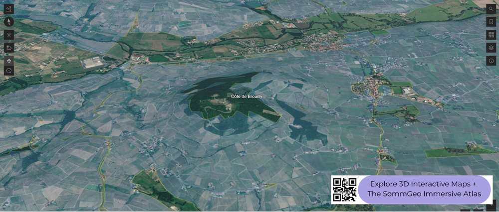
South of the Mâconnais, the geology shifts from limestone to granite in the northern crus, and with it the grape changes from Chardonnay and Pinot Noir to Gamay. The ten Beaujolais crus (Morgon, Moulin-à-Vent, Fleurie, Brouilly, Côte de Brouilly, and five others) occupy the northern half of the region on granite and schist soils at elevations between roughly 250 and 500 meters (820 and 1,640 ft). The Côte de Brouilly, visible in the screenshot, wraps the upper slopes of Mont Brouilly, a volcanic diorite hill that produces wines with a distinct mineral firmness compared to the broader Brouilly appellation at its base. Southern Beaujolais, on clay-limestone, produces the lighter Beaujolais and Beaujolais-Villages. The terrain contrast between the granitic cru hills in the north and the flatter southern plains is clearly visible in 3D.
Jura and Savoie
East of Burgundy, the Jura vineyards sit on a narrow strip of the western foothills of the Jura Mountains, between the Bresse plain and the high ridges, with the best sites planted on south-facing slopes at elevations ranging from 250 to 400 meters (820 to 1,312 ft) The soils are predominantly Jurassic-era limestone and marl. Jura’s signature is Vin Jaune from Savagnin, aged under a film of flor yeast for a minimum of 60 months in barrel, a process that gives it the oxidative, nutty character that is unlike anything else in France. Château-Chalon is the appellation most associated with Vin Jaune. Arbois and Côtes du Jura cover a wider range of styles including reds from Poulsard and Trousseau. Further east and south, Savoie’s vineyards cling to alpine valleys and lakeshores, with Jacquère producing light, crisp whites and Mondeuse making structured, peppery reds. The terrain here is visibly mountainous, a sharp contrast to the gentler slopes of Burgundy.
New to 3D Fast Maps? Learn how to navigate 3D terrain, use elevation profiles, animate sunlight, and get the most from your map.
3D Fast Maps Guide →Ready to explore these wine regions in full 3D? Join 200+ wine organizations already using SommGeo.
Start Your 15-Day Free Trial $5/month billed annually after trial · Cancel anytimeMap Usage & Permissions
Personal Use
You are welcome to use, download, and share the maps on this site for personal, educational, and non-commercial purposes. If you share a map, please credit SommGeo with a link back to sommgeo.com.
Commercial Use
Use of these maps for any commercial purpose, including websites, print publications, marketing materials, or any other commercial venture, is strictly prohibited without prior written permission.
To inquire about custom SommGeo platforms, maps, or commercial licensing, please contact greg@sommgeo.com.