Portugal 3D Wine Map
The Douro, Dão, Alentejo, Vinho Verde, Madeira, and the Azores in full 3D terrain.
Portugal packs an extraordinary range of geography into a small footprint. From the terraced schist slopes of the Douro Valley to the granite highlands of the Dão, from the rolling plains of the Alentejo to the volcanic islands of Madeira and the Azores, the terrain shifts constantly. This is a country defined by indigenous grape varieties (over 250 in active use) grown in landscapes that look nothing alike from one region to the next. This map covers Portugal’s DOC and other designated wine regions with detailed popup data. The bookmarks are essential: use them to fly between mainland regions, then out to Madeira and the Azores, where the volcanic island terrain is as striking as anything on the map. The layer controls let you shading or outlines.
Unlock the Full SommGeo Toolkit
Gain exclusive access to our entire suite of premium features, including interactive Map Makers, immersive 3D Tours, high-resolution classic Maps, and advanced analytical tools.
Start Free TrialWhat You’ll Explore
This 3D Fast Map covers Portugal’s wine regions across the mainland and the Atlantic islands. Click any mapped region for detailed popup content covering grape varieties, classification details, and geographic specifics. Start with the bookmarks: they will fly you between the Douro, the Dão, the Alentejo, and the other mainland regions, then out into the Atlantic to Madeira and the Azores, where the volcanic island landscapes are best experienced by letting the bookmark carry you there.
- Portugal’s DOC wine regions mapped across the mainland and Atlantic islands
- Bookmarks to fly between mainland regions and out to Madeira and the Azores
- Elevation profile tool for measuring vineyard altitude and slope gradients
- Daylight and shadow animation to visualize aspect and sun exposure
Key Regions in Focus
The Douro Valley
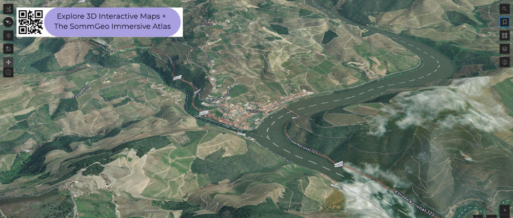
The Douro is one of the most visually stunning wine regions in the world. The river has carved a deep valley through schist, and vineyards climb terraces from the riverbank to over 600 meters (1,970 feet). The valley divides into Baixo Corgo (coolest, highest rainfall), Cima Corgo (where Pinhão sits, home to many of the finest Port and unfortified wines), and Douro Superior (hottest, most arid). Touriga Nacional, Touriga Franca, Tinta Roriz, Tinta Barroca, and Tinto Cão are the key reds. The elevation profile tool is particularly rewarding here for tracing terrace altitude and understanding the immense human engineering that makes this landscape productive.
Dão, Alentejo, and the Mainland
The Dão occupies a granite plateau ringed by mountain ranges (Serra da Estrela, Caramúlo, Buçaco, and Nave) that shelter it from Atlantic moisture and continental extremes. Vineyards sit at 400 to 800 meters (1,310 to 2,625 feet), and Touriga Nacional produces some of its most elegant expressions here. The Alentejo, covering the vast interior south of the Tagus, is warmer, drier, and flatter, producing rich reds from Alicante Bouschet, Trincadeira, and Aragonez on clay, schist, and granite. Vinho Verde in the northwest is the geographic opposite: cool, wet, and green, with vines trained on pergolas in the Mínho valleys. Bairrada, Lisíboa, Setúbal, and Tejo fill in the coastal and central areas.
Madeira and the Azores
The Atlantic islands are where the bookmarks really shine. Madeira, roughly 1,000 kilometers (620 miles) southwest of Lisbon, is volcanic with vineyards on steep terraces (poios) from sea level to over 800 meters (2,625 feet). The altitude drives style: Sercial and Verdelho at higher, cooler sites produce drier wines, while Bual and Malvasia at lower positions produce richer, sweeter styles. The Azores, over 1,500 kilometers (930 miles) west of mainland Portugal in the mid-Atlantic, grow vines in currais (walled basalt enclosures) on Pico Island to protect against salt spray and wind. Fly out from the mainland using the bookmarks and the scale and isolation of these volcanic islands become immediately tangible in 3D.
New to 3D Fast Maps? Learn how to navigate 3D terrain, use elevation profiles, animate sunlight, and get the most from your map.
3D Fast Maps Guide →Ready to explore Portugal’s wine regions in full 3D? Join 200+ wine organizations already using SommGeo.
Start Your 15-Day Free Trial $5/month billed annually after trial · Cancel anytimeMap Usage & Permissions
Personal Use
You are welcome to use, download, and share the maps on this site for personal, educational, and non-commercial purposes. If you share a map, please credit SommGeo with a link back to sommgeo.com.
Commercial Use
Use of these maps for any commercial purpose, including websites, print publications, marketing materials, or any other commercial venture, is strictly prohibited without prior written permission.
To inquire about custom SommGeo platforms, maps, or commercial licensing, please contact greg@sommgeo.com.

