
Cyprus 3D Wine Map
The Troodos Mountains, Commandaria, and the indigenous varieties of the eastern Mediterranean.
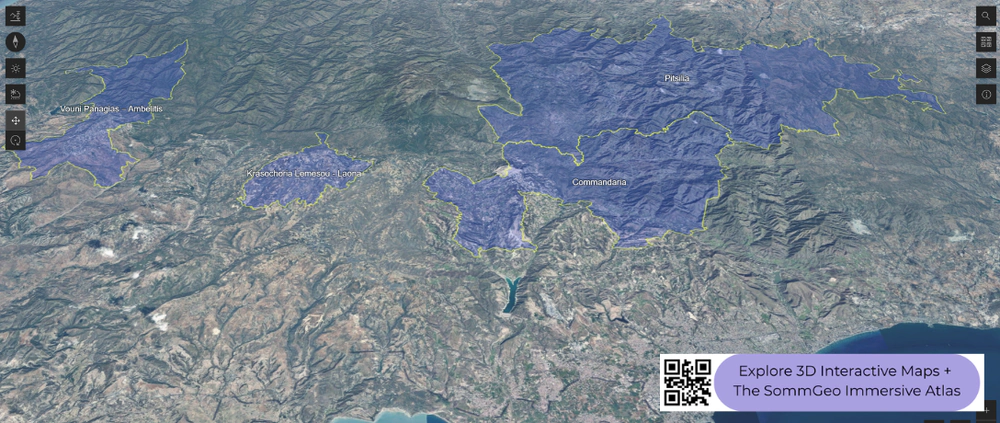
Cyprus has been making wine for at least 5,500 years, placing it among the oldest continuous wine cultures on earth. The island’s viticulture is defined almost entirely by one geographic feature: the Troodos Mountains, a massive igneous range that rises to 1,952 meters (6,404 ft) at Mount Olympus in the center of the island. The coastal lowlands are too hot and dry for quality grape-growing, so most vineyards of consequence sit on the mountain slopes, between roughly 600 and 1,500 meters (1,968 and 4,921 ft), where altitude brings cooler temperatures, greater diurnal shifts, and enough rainfall to sustain vines. This 3D Fast Map shows that relationship between mountain and vine clearly, with the Troodos dominating the center of the island.
Unlock the Full SommGeo Toolkit
Gain exclusive access to our entire suite of premium features, including interactive Map Makers, immersive 3D Tours, high-resolution classic Maps, and advanced analytical tools.
Start Free TrialWhat You’ll Explore
This 3D Fast Map covers the wine regions of Cyprus, centered on the Troodos Mountain slopes where the island’s vineyards are concentrated. Click any mapped region for detailed popup content covering grape varieties, classification details, and geographic specifics. Use the layer controls to toggle different region groupings on and off.
- Full 3D terrain of Cyprus with the Troodos Mountains and vineyard zones
- Elevation profile tool for measuring vineyard altitude and slope gradients
- Daylight and shadow animation to visualize aspect and sun exposure
- Detailed popup data for every mapped region: varieties, classifications, geography
Key Regions in Focus
The Troodos Mountains
The Troodos range is the entire story of Cypriot viticulture. The mountain slopes, primarily on the southern and western flanks facing Limassol and Paphos, hold the vast majority of the island’s vineyard area. Elevations range from around 600 meters (1,968 ft) in the lower foothills to above 1,500 meters (4,921 ft) on the highest planted sites, and that altitude range translates directly into different grape varieties and wine styles. Xynisteri, the island’s dominant white grape, is planted across multiple elevations and produces crisp, citrus-driven wines at higher sites and broader, softer styles lower down. Mavro, the workhorse red, is widely planted but increasingly supplemented by Maratheftiko, an indigenous red with more structure and aromatic complexity that has become the focus of quality-minded producers. Yiannoudi, another native red, adds color and tannin in blends. The igneous soils (the Troodos range is an exposed section of oceanic crust, or ophiolite) give the wines a distinct mineral signature that is difficult to separate from the altitude and climate effects.
Commandaria
Commandaria is the oldest continuously produced named wine in the world, with documentation stretching back to at least the 12th century when the Knights Templar and later the Knights of St. John controlled the region and gave the wine its name (from “commanderie,” the knights’ estates). The Commandaria zone is strictly delimited to 14 villages on the southern foothills of the Troodos, between roughly 400 and 900 meters (1,312 and 2,953 ft). The wine is made from sun-dried Xynisteri and Mavro grapes, producing a rich, amber sweet wine with flavors of dried fruit, caramel, and honey. The drying process (similar in concept to Italian passito) concentrates sugars and flavors before fermentation. Commandaria holds PDO status, and while the codified regulations date to 1990, the underlying method of sun-drying indigenous grapes to produce a rich sweet wine traces an unbroken line back through centuries of Mediterranean winemaking, making it a genuinely unique artifact of wine history.
New to 3D Fast Maps? Learn how to navigate 3D terrain, use elevation profiles, animate sunlight, and get the most from your map.
3D Fast Maps Guide →Ready to explore Cyprus wine regions in full 3D? Join 200+ wine organizations already using SommGeo.
Start Your 15-Day Free Trial $5/month billed annually after trial · Cancel anytimeMap Usage & Permissions
Personal Use
You are welcome to use, download, and share the maps on this site for personal, educational, and non-commercial purposes. If you share a map, please credit SommGeo with a link back to sommgeo.com.
Commercial Use
Use of these maps for any commercial purpose, including websites, print publications, marketing materials, or any other commercial venture, is strictly prohibited without prior written permission.
To inquire about custom SommGeo platforms, maps, or commercial licensing, please contact greg@sommgeo.com.