
New Zealand North Island 3D Wine Map
Hawke’s Bay, Martinborough, Waiheke Island, Gisborne, and the North Island wine regions in full 3D terrain.
The North Island of New Zealand is where the country’s wine industry began and where its most diverse range of styles is produced. From the warm, Bordeaux-inspired reds of Hawke’s Bay to the cool-climate Pinot Noir of Martinborough, to the coastal Chardonnay of Gisborne, the terrain shifts dramatically across relatively short distances. Maritime influence is constant but varies in intensity, and the interplay of altitude, aspect, and proximity to the coast shapes site character in measurable ways. This map covers the North Island’s wine regions and subregions with detailed popup data on each. Use the layer controls to change between shading and outlines and the elevation profile tool to trace the altitude gradients that separate the island’s distinct growing zones.
Unlock the Full SommGeo Toolkit
Gain exclusive access to our entire suite of premium features, including interactive Map Makers, immersive 3D Tours, high-resolution classic Maps, and advanced analytical tools.
Start Free TrialWhat You’ll Explore
This 3D Fast Map covers the wine regions and subregions of New Zealand’s North Island. Click any mapped area for detailed popup content covering grape varieties, climate details, and geographic specifics. Use the layer controls to toggle different regional groupings on and off and the elevation profile tool to trace the terrain differences between coastal and inland growing sites.
- North Island wine regions and subregions mapped with detailed popup data
- Elevation profile tool for measuring vineyard altitude and slope gradients
- Daylight and shadow animation to visualize aspect and sun exposure
- Detailed popup data for every mapped region and subregion
Key Regions in Focus
Hawke’s Bay
Hawke’s Bay is the North Island’s most important red wine region. The Gimblett Gravels, a roughly 800-hectare (1,977-acre) area of free-draining alluvial gravel from the old Ngaruroro riverbed, is the standout subregion: stony soils retain heat and radiate it back at night, ripening Cabernet Sauvignon, Merlot, and Syrah to a concentration rare in New Zealand.
Wairarapa and Martinborough
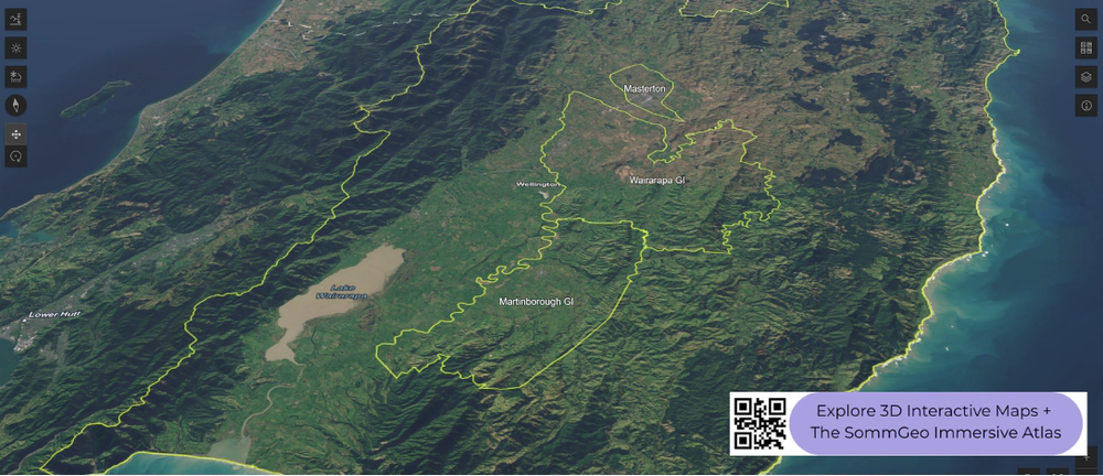
The Wairarapa sits at the southern tip of the North Island, tucked in the rain shadow of the Rimutaka (Remutaka) Range. Martinborough, the most celebrated subregion, occupies river terraces at low elevation with free-draining alluvial gravels over clay. Shelter from westerly rain, cooling winds from the south, and well-drained soils make this one of the best Pinot Noir sites in the country. Production scale is small and vineyards are concentrated in a compact area. The 3D terrain makes the rain shadow visible: the Remutaka and Tararua Ranges rise steeply to the west, and Martinborough sits in the dry zone immediately behind them. The elevation profile tool is useful for measuring the range and understanding why the eastern side stays drier.
Auckland, Waiheke, and Gisborne
Auckland’s wine regions are scattered across distinct sites. Waiheke Island, has a warm microclimate and clay soils over weathered Jurassic greywacke that produce concentrated Bordeaux-style reds and Syrah on a small scale. On the mainland northwest of the city, Kumeu is one of New Zealand’s top sources for Chardonnay, while Matakana, north of Auckland, produces Pinot Gris and Bordeaux varieties in a warmer coastal setting. Gisborne is one of New Zealand’s sunniest wine regions, with fertile alluvial soils producing the country’s largest volumes of Chardonnay alongside increasingly respected Gewürztraminer. The 3D terrain highlights Waiheke’s island geography and the flat, coastal character of the Gisborne plains.
New to 3D Fast Maps? Learn how to navigate 3D terrain, use elevation profiles, animate sunlight, and get the most from your map.
3D Fast Maps Guide →Ready to explore the New Zealand North Island in full 3D? Join 200+ wine organizations already using SommGeo.
Start Your 15-Day Free Trial $5/month billed annually after trial · Cancel anytimeMap Usage
Free for your own study and tastings. If you share or teach with a map, credit it visibly as Map: SommGeo (sommgeo.com). Commercial use requires a Commercial Embed License. See Map Usage, Credit and Licensing.