Napa Valley Wine Map — Free Download
Seventeen nested AVAs in a strip of land barely thirty miles long, and the geography that lets one valley make its classic version of Cabernet.
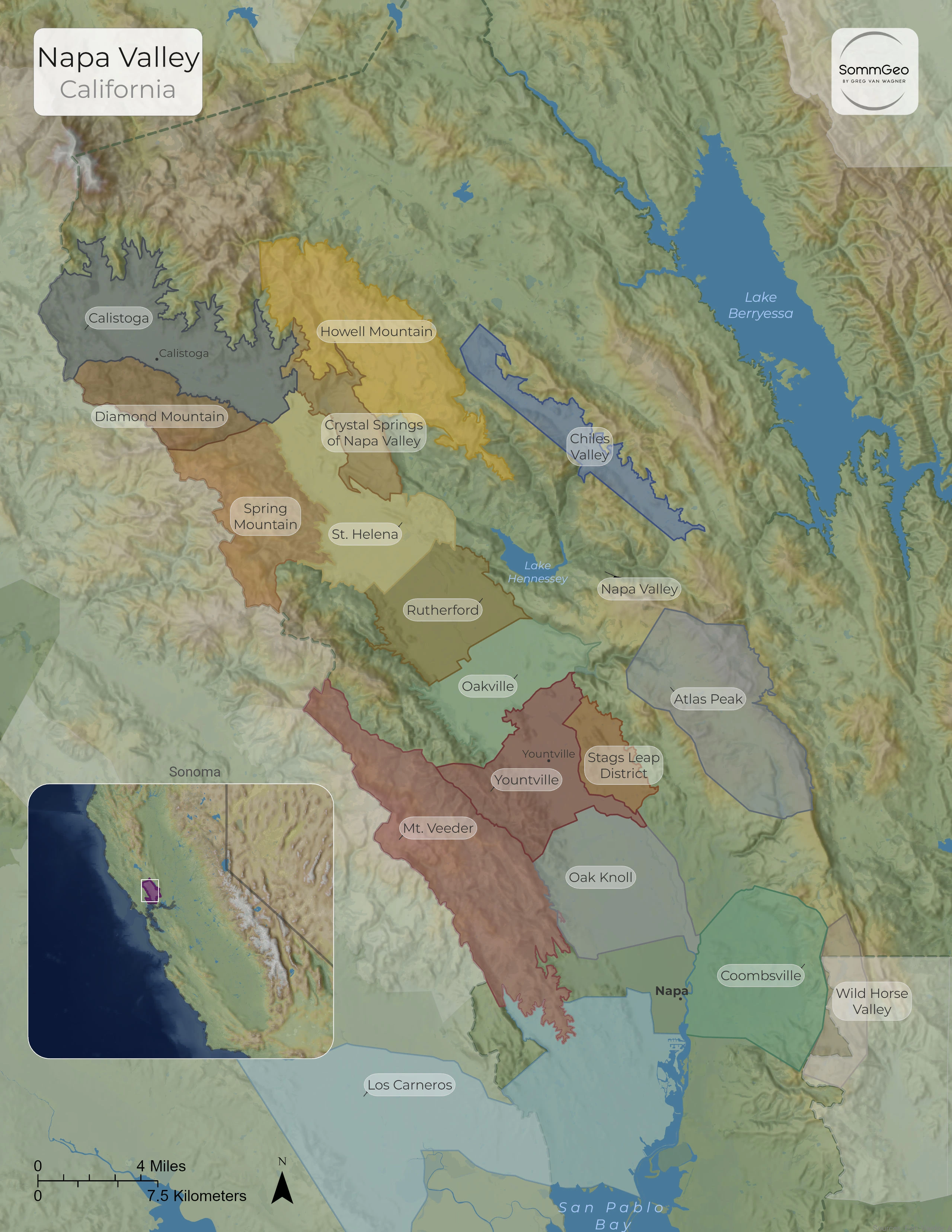
This Napa Valley wine map covers California’s most famous wine region and the 17 nested AVAs packed into a strip of land barely 30 miles (48 km) long. Napa is Cabernet Sauvignon country first and foremost, but the reason it can make so many distinct styles of wine from one grape comes down to geography: a sharp climate gradient from the cool, fog-soaked south to the warm north, two mountain ranges with very different geology, and a valley floor of overlapping alluvial fans. From Los Carneros at the edge of San Pablo Bay to Calistoga at the foot of Mount Saint Helena, and from the valley benchland up to mountain vineyards above 2,000 feet (610 m), each sub-appellation carries its own clear sense of place. Download the free map below to see how all 17 AVAs fit together.
What This Map Covers
This classic map shows the full nested-AVA structure of Napa Valley, every sub-appellation from San Pablo Bay to Calistoga drawn on the actual terrain so you can see how valley floor and mountain sit in relation to one another. You’ll see the Cabernet heartland of Oakville and Rutherford on the valley floor, the ring of mountain AVAs climbing the Mayacamas and Vaca ranges on either side, and the cool southern AVAs that open toward the bay.
- All 17 nested AVAs, from Los Carneros and Coombsville in the south to Calistoga in the north
- The valley-floor benchland AVAs: Oakville, Rutherford, St. Helena, Yountville, and Oak Knoll District
- The western mountain AVAs in the Mayacamas: Mt. Veeder, Spring Mountain District, and Diamond Mountain District
- The eastern mountain and hillside AVAs in the Vaca range: Howell Mountain, Atlas Peak, Chiles Valley, and the new Crystal Springs of Napa Valley
- Stags Leap District and Coombsville along the valley’s eastern and southeastern edges
- The cool southern fringe shaped by San Pablo Bay, plus Lake Berryessa, Lake Hennessey, and the Sonoma county line
Geography and Site Character
Napa’s signature is contrast. The valley runs roughly north to south, open at its southern end to the cold water and fog of San Pablo Bay and closing at the north against Mount Saint Helena. That single fact drives everything. Cool marine air and morning fog push up the valley from the bay each night, so the southern AVAs like Los Carneros, Coombsville, and Oak Knoll District run markedly cooler than the warm northern end around Calistoga and St. Helena, which can sit 10 to 15°F (about 6 to 8°C) hotter on a summer afternoon. That large day-to-night temperature swing, the diurnal shift, is what lets Napa ripen Cabernet fully while holding the acidity and structure that keep the wines from going flat.
Elevation tells the second half of the story. The valley floor is built from overlapping alluvial fans washed down from both mountain ranges, deeper and more fertile ground that gives the rich, generous style most people picture when they think of Napa Cabernet. Above the valley, the mountain AVAs sit on thinner, rockier soils and, crucially, above the fog line, where they get more sun and a smaller day-night swing. These hillside vineyards produce smaller berries, firmer tannins, and more concentrated, structured wines. The two ranges differ as well: the Mayacamas to the west mix sedimentary and volcanic rock, while the Vaca range to the east, holding Howell Mountain, Atlas Peak, and the volcanic-ash slopes of Crystal Springs, runs more strongly volcanic. It is this stack of variables, bay to mountain and fan to bedrock, that gives each AVA its own site character.
The Valley Floor: Napa’s Cabernet Heartland
The benchland AVAs along the valley floor are the historic core of Napa Cabernet, and the run from Oakville to Rutherford is its center. Oakville, home to the historic To Kalon vineyard, makes structured, age-worthy Cabernet and is the base for sought-after names like Harlan Estate and Screaming Eagle. Rutherford, just north, is known for a dusty, earthy tannin grip that growers have long called Rutherford dust, with the historic Inglenook estate among its landmarks. St. Helena sits in the warm, narrow waist of the valley and gives ripe, full-bodied wines, while cooler Yountville and Oak Knoll District toward the south run leaner and more aromatic. At the far north, warm Calistoga closes the valley with rich, dark Cabernet from producers like Chateau Montelena.
The Mountain AVAs
Ringing the valley floor, the hillside AVAs trade some richness for grip and structure. On the western Mayacamas side, Mt. Veeder, Spring Mountain District, and Diamond Mountain District grow Cabernet on steep, thin soils. Mt. Veeder is one of the cooler mountain AVAs, giving firm, age-worthy Cabernet and Merlot, and it is home to Mayacamas Vineyards, whose old-school, long-lived wines are a benchmark for the style. Diamond Mountain takes its name from the volcanic glass that glitters in its soils, and Spring Mountain, the wettest AVA in Napa, catches the Pacific influence spilling over the ridge from the west. Across the valley on the eastern Vaca side, Howell Mountain was Napa’s first sub-AVA, sitting entirely above the fog line beyond 1,400 feet (427 m) and known for tannic, long-lived Cabernet and Zinfandel. Randy Dunn helped build that reputation, bottling both a Howell Mountain Cabernet and a Napa Valley cuvee that brings in fruit from below the hill. Atlas Peak and Chiles Valley climb the same range at altitude, cooler and later-ripening, and the newest AVA of all, Crystal Springs of Napa Valley, recognized in 2024, is an all-hillside appellation of volcanic-ash slopes tucked below Howell Mountain between St. Helena and Calistoga.
Stags Leap District and the Cool South
Two more corners of the valley round out the picture. Stags Leap District, on the eastern edge below the rocky Stags Leap Palisades, is known for Cabernet that pairs firm structure with a supple, almost velvety texture, the style that drew the world’s attention to Napa at the 1976 Judgment of Paris. To the south and southeast, the coolest parts of the valley open toward the bay. Los Carneros, shared with Sonoma, is cool and windswept enough to lean toward Pinot Noir, Chardonnay, and sparkling wine rather than Cabernet, and Merlot finds a natural home across this cooler southern stretch, where clay-rich soils and milder temperatures suit it well. Coombsville, just east of the city of Napa, and high, breezy Wild Horse Valley round out the southern fringe, turning out fresher, more restrained reds than the warm heart of the valley.
Want to explore Napa Valley and the rest of California’s North Coast in 3D with interactive AVA layers, elevation data, and climate gradients? Join 200+ wine organizations already using SommGeo.
Start Your 15-Day Free Trial $5/month billed annually after trial · Cancel anytimeMap Usage & Permissions
Personal Use
You are welcome to use, download, and share the maps on this site for personal, educational, and non-commercial purposes. If you share a map, please credit SommGeo with a link back to sommgeo.com.
Commercial Use
Use of these maps for any commercial purpose — including websites, print publications, marketing materials, or any other commercial venture — is strictly prohibited without prior written permission.
To inquire about custom SommGeo platforms, maps, or commercial licensing, please contact greg@sommgeo.com.