Germany Wine Regions Map Maker: Interactive 3D Wine Map
Thirteen Anbaugebiete, one country that rewrote the rules on what cool-climate wine can be, from the vertiginous Mosel to the sun-baked Rhine plain.
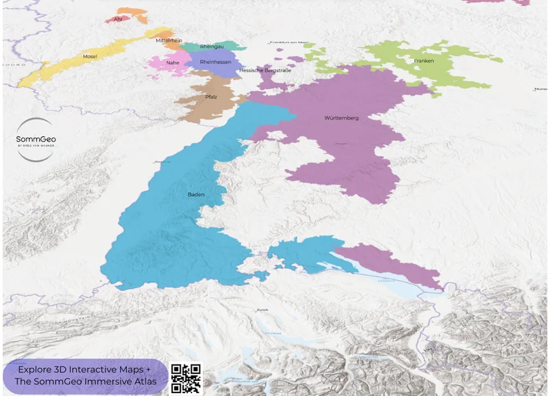
Germany is one of the most geographically fascinating wine countries on the planet, and this Germany wine regions map lets you explore exactly why. With approximately 103,000 hectares (254,518 acres) of vineyard spread across 13 officially designated wine regions (the Anbaugebiete) it’s a country where rivers do the heavy lifting. The Rhine and its tributaries (the Mosel, Nahe, Ahr, Main, Neckar) carve the valleys, create the slopes, and generate the mesoclimates that make viticulture possible at latitudes where, by all rights, grapes shouldn’t ripen at all. This Map Maker puts all 13 regions at your fingertips in full 3D, so you can see how the steep slate slopes of the Mosel differ from the broad, warm Rhine plain of Rheinhessen, or why the tiny Ahr Valley (tucked into a narrow gorge) manages to produce world-class Spätburgunder despite sitting at one of the most northerly latitudes for red wine production in Europe. Every mapped region includes detailed popup content covering grape varieties, classification systems, climate profiles, soil types, a sommelier-level reference built directly into the map.
Unlock the Full SommGeo Toolkit
Gain exclusive access to our entire suite of premium features, including interactive Map Makers, immersive 3D Tours, high-resolution classic Maps, and advanced analytical tools.
Start Free TrialWhat You’ll Explore
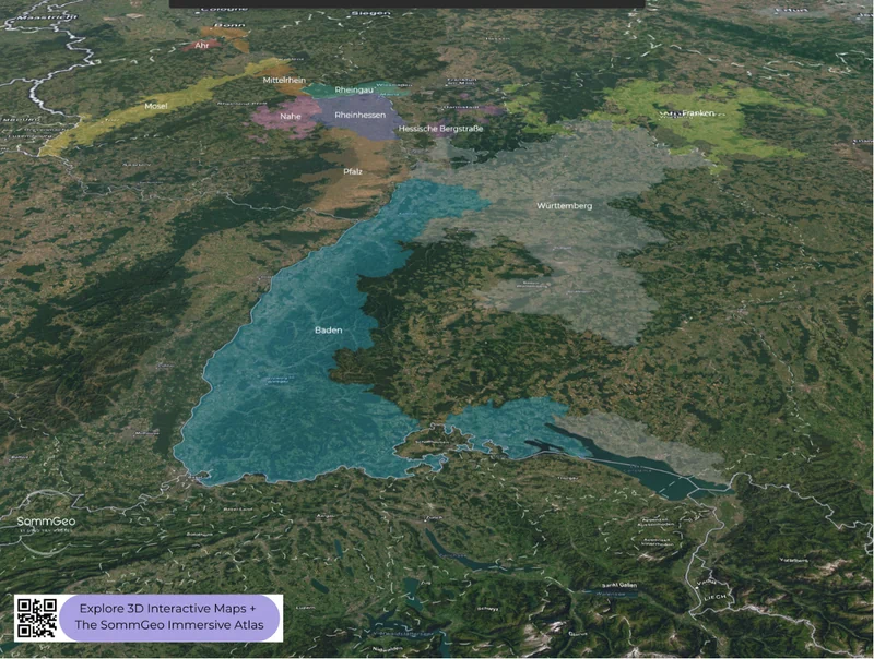
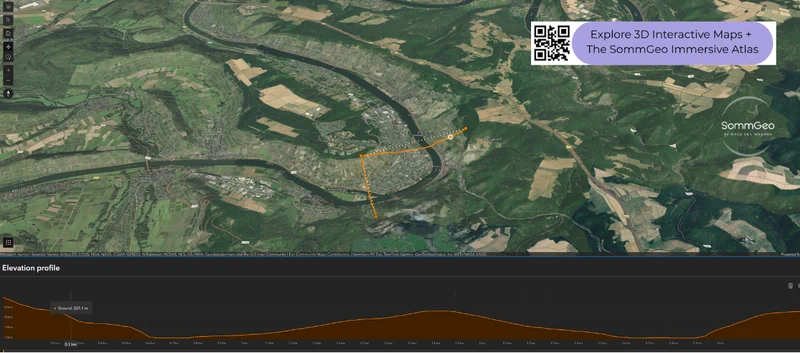
This Map Maker covers all 13 of Germany’s officially designated wine regions (Anbaugebiete), but the real depth is in what each region reveals. Click on any mapped area and a comprehensive info panel opens with sommelier-level content: dominant grape varieties, classification hierarchies, soil and geological profiles, climate data, and the geographic specifics that define each region’s wines. Whether you’re reading about the Devonian slate driving Mosel Riesling’s mineral character, the loess deposits of Rheinhessen, or the volcanic soils of the Kaiserstuhl in Baden, every mapped region carries this level of built-in intelligence. Beyond the content, you can build custom 3D views using satellite imagery, topographic relief, or clean outline basemaps, and the elevation tools let you profile the slopes that define German viticulture.
- All 13 Anbaugebiete mapped with region boundaries and color-coded overlays
- In-depth region profiles for every mapped area: varieties, classification rules, geology, climate
- Elevation profile tool for measuring slope gradients across vineyard areas
- Multiple basemap options: satellite imagery, topographic contours, and clean outline views
- Zoom from the full country view down to individual river bends and valley floors
- Save and download custom map views for study, presentations, or personal reference
Geography and Climate of German Wine
Germany sits at the very northern edge of viable viticulture (roughly between the 47th and 52nd parallels) and the entire story of German wine is essentially a story of how geography conspires to make grape-growing possible in places where it shouldn’t be. Rivers are the protagonists. The Rhine and its tributaries carved the valleys that create the south- and southwest-facing slopes needed to capture maximum sunlight, and the water itself acts as a thermal regulator, moderating temperatures and reflecting additional light onto the vines. Without these river systems, German wine as we know it simply wouldn’t exist.
The 13 Anbaugebiete cluster overwhelmingly in the southwest, in the states of Rheinland-Pfalz, Hessen, and Baden-Württemberg, where the confluence of river influence, mountain shelter, and relatively mild Atlantic weather patterns creates the most favorable conditions. The two eastern exceptions (Saale-Unstrut and Sachsen) sit on different river systems entirely (the Saale, Unstrut, and Elbe) and produce wines in a distinctly northern continental climate.
Soil diversity across the 13 regions is staggering. The Mosel’s famous blue and red Devonian slate retains and radiates heat while driving the steely mineral character of its Rieslings. The Rheingau sits on Taunus quartzite and phyllite. The Pfalz and Rheinhessen span everything from loess and limestone to clay and sandstone on the broad Rhine terrace. Baden, Germany’s warmest and southernmost region, ranges from the volcanic Kaiserstuhl (literally “Emperor’s Throne”) to the limestone slopes along the Bodensee. And the Ahr’s dark slate and greywacke soils play a critical role in ripening Pinot Noir at a latitude where red wine production seems improbable. The 3D relief view in the Map Maker is the fastest way to grasp how dramatically different these landscapes are from one another.
Key Wine Regions
The Mosel
The Mosel is Germany’s most iconic wine region and, frankly, one of the most visually dramatic vineyard landscapes anywhere on earth. The river carves a serpentine path from the French border to its confluence with the Rhine at Koblenz, and at every bend, vertiginously steep south-facing slopes of Devonian slate rise from the water’s edge. These are among the steepest vineyards in the world (some exceeding 65% gradient) and virtually all work must be done by hand. The region also encompasses the Saar and Ruwer tributaries, which produce some of Germany’s most refined and age-worthy Rieslings in a slightly cooler, more restrained style. Around 60% of the region’s roughly 8,800 hectares (21,745 acres) is planted to Riesling, and the best sites along the Mittelmosel (the middle section, between Trittenheim and Zell) produce wines of extraordinary precision: featherweight in body, electric in acidity, and capable of developing for decades in bottle.
The Rheingau
The Rheingau is small (roughly 3,200 hectares (7,907 acres)) but its historical significance is outsized. This is where Riesling was first documented (in a 1435 invoice from Count Johann IV of Katzenelnbogen), and where the concept of late-harvest wines was essentially invented. The geography is unique along the Rhine: for a roughly 30-kilometer (19 miles) stretch between Wiesbaden and Rüdesheim, the river turns from its north-south course to flow east-west, creating a band of south-facing slopes sheltered by the Taunus Mountains to the north. Riesling accounts for nearly 80% of plantings, and the dry Rieslings produced here, historically Germany’s most prestigious and expensive whites, tend toward a broader, more powerful style compared to the Mosel’s wire-thin elegance. Spätburgunder (Pinot Noir) makes up about 12% of plantings, concentrated around Assmannshausen.
The Pfalz & Rheinhessen
These two neighboring regions account for nearly half of all German wine production between them. Rheinhessen is the largest region at approximately 27,000 hectares (66,718 acres), while the Pfalz covers about 23,000 hectares (56,834 acres) stretching south to the French border. Both benefit from the rain shadow of the Haardt Mountains (the northern continuation of the Vosges range in Alsace) and the broad, warm Rhine plain. The Pfalz receives around 1,800 hours of sunshine annually (nearly Mediterranean for Germany) which allows a wider range of varieties to thrive, including substantial Spätburgunder, Grauburgunder (Pinot Gris), Weissburgunder (Pinot Blanc), and Chardonnay alongside the inevitable Riesling. Rheinhessen, long associated with bulk production, has undergone a dramatic quality revolution over the past two decades, with the steep vineyard sites along the Rheinterrasse (the Rhine terrace between Nackenheim and Nierstein) now producing serious, site-specific dry Rieslings that compete with anything from the Rheingau.
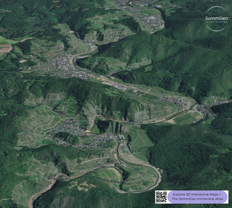
The Ahr
The Ahr is a region that shouldn’t work on paper. At roughly 560 hectares (1,384 acres), it’s one of Germany’s smallest Anbaugebiete, and its position in a narrow valley of the Ahr River (a tributary of the Rhine south of Bonn) places it among the most northerly red wine regions in Europe. Yet the combination of dark slate and greywacke soils, steep south-facing slopes, and a sheltered valley microclimate creates conditions where Spätburgunder thrives, accounting for roughly 65% of plantings. The best Ahr Pinots combine a Burgundian sensibility with a distinctly German freshness, and the region has earned a serious reputation among collectors. The devastating floods of 2021 destroyed significant vineyard infrastructure, but the rebuilding effort has been remarkable, and the Ahr remains one of German wine’s most compelling stories.
Baden, Franken & the Eastern Regions
Baden is Germany’s outlier in almost every sense: the southernmost, warmest, and most geographically sprawling region, stretching some 400 kilometers (249 miles) from Heidelberg to the Bodensee (Lake Constance) along the Swiss and French borders. It’s the only German region classified in EU wine zone B (the same as Alsace and Champagne), and red wine plays a far larger role here than in other German regions, with Spätburgunder dominating the volcanic slopes of the Kaiserstuhl. Franken, anchored by the city of Würzburg on the Main River, is Silvaner country; the region’s signature grape produces dry, earthy wines traditionally sold in the squat Bocksbeutel bottle. And in the east, Saale-Unstrut and Sachsen (Germany’s smallest region, centered on Dresden along the Elbe) produce small quantities of characterful dry whites: predominantly Müller-Thurgau, Weissburgunder, and Riesling, in a continental climate with cold winters. Nearly all of their production is consumed locally, making them genuine insider discoveries.
New to the Map Makers? Explore all the tools, tips, and features in our complete walkthrough.
Map Maker Guide →Ready to explore Germany’s 13 wine regions in full 3D with interactive layers and elevation tools? Join 200+ wine organizations already using SommGeo.
Start Your 15-Day Free Trial $5/month billed annually after trial · Cancel anytimePlease let us know what you think in the form below. Thanks!

