Bordeaux & Southwest France 3D Wine Map
The Left Bank, Right Bank, Sauternes, and the appellations of Southwest France in full 3D terrain.
Bordeaux’s geography is organized by its rivers. The Garonne and the Dordogne converge to form the Gironde estuary, and the land between and around these waterways defines the Left Bank, Right Bank, and Entre-Deux-Mers. What the flat maps cannot convey is how subtle the terrain differences actually are: the gravel banks of the Médoc, the clay plateau of Pomerol, the limestone côtes and plateau of Saint-Émilion, the low-lying Ciron valley that generates the mists for Sauternes In 3D, these features become visible. This map extends beyond Bordeaux proper into the appellations of Southwest France, where Cahors, Bergerac, Madiran, Jurançon, and others occupy the foothills and river valleys leading toward the Pyrenees.
Unlock the Full SommGeo Toolkit
Gain exclusive access to our entire suite of premium features, including interactive Map Makers, immersive 3D Tours, high-resolution classic Maps, and advanced analytical tools.
Start Free TrialWhat You’ll Explore
This 3D Fast Map covers the appellations of Bordeaux and extends into Southwest France. Click any mapped appellation for detailed popup content covering grape varieties, classification details, and geographic specifics. Use the bookmarks to jump between key areas and the layer controls to toggle different appellation groupings.
- Full 3D terrain of Bordeaux and Southwest France appellations
- Bookmarks for quick navigation to key areas within the map
- Toggleable layers to control which appellation groupings are displayed
- Elevation profile tool for measuring vineyard altitude and slope gradients
- Daylight and shadow animation to visualize aspect and sun exposure
- Weather overlay to see how atmospheric conditions interact with terrain
Key Regions in Focus
Left Bank: The Médoc and Graves
The Left Bank of the Gironde and Garonne is Cabernet Sauvignon country, and its terroir story is about gravel. The Médoc peninsula, running roughly 80 kilometers (50 miles) north from the city of Bordeaux along the Gironde estuary, is where the classified growths of the 1855 Classification sit. The gravel mounds (croupes) deposited by the Garonne during glacial periods provide the drainage that Cabernet Sauvignon needs, and the estuary moderates temperatures. The commune appellations (Margaux, Saint-Julien, Pauillac, Saint-Estèphe) each sit on slightly different gravel compositions and elevations that the 3D terrain can help distinguish. South of the city, Pessac-Léognan and the broader Graves appellation sit on similar gravel over limestone, producing both reds and the dry whites that the Médoc generally does not.
Right Bank: Saint-Émilion and Pomerol
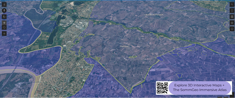
East of the Dordogne, the Right Bank is Merlot territory, and the terrain is more varied than the Left Bank. Saint-Émilion divides geographically into the limestone plateau (where many of the top châteaux sit on a cap of calcaire à astéries), the côtes (clay-limestone slopes around the town), and the lower, sandier plains toward the river. Pomerol, just to the northwest, occupies a small, gently elevated plateau where the buttonhole of blue clay at the center (near Pétrus) creates different drainage and water-retention conditions than the surrounding gravel and sand. The entire Pomerol appellation covers barely 800 hectares (1,977 acres), and the elevation differences that define its best sites are measured in meters rather than tens of meters. This is where 3D terrain becomes genuinely useful: the plateau and its edges are subtle in person but traceable in the map.
Southwest France
Beyond Bordeaux, the Southwest appellations follow the river systems southeast toward the Pyrenees. Bergerac and its sub-appellations (Monbazillac, Pécharmant, Saussignac) sit on the Dordogne upstream from Saint-Émilion, using the same grape varieties in a similar but slightly warmer climate. Cahors, on the Lot River, is Malbec’s historic home, where the grape (locally called Côt) produces firm, dark, tannic wines on the limestone causses and gravel terraces above the river. Further south, Madiran and Jurançon occupy Pyrenean foothills, where Tannat and Petit Manseng respectively produce wines of real power and concentration in landscapes that become visibly mountainous in the 3D terrain.
New to 3D Fast Maps? Learn how to navigate 3D terrain, use elevation profiles, animate sunlight, and get the most from your map.
3D Fast Maps Guide →Ready to explore Bordeaux and Southwest France in full 3D? Join 200+ wine organizations already using SommGeo.
Start Your 15-Day Free Trial $5/month billed annually after trial · Cancel anytimeMap Usage & Permissions
Personal Use
You are welcome to use, download, and share the maps on this site for personal, educational, and non-commercial purposes. If you share a map, please credit SommGeo with a link back to sommgeo.com.
Commercial Use
Use of these maps for any commercial purpose, including websites, print publications, marketing materials, or any other commercial venture, is strictly prohibited without prior written permission.
To inquire about custom SommGeo platforms, maps, or commercial licensing, please contact greg@sommgeo.com.

