Southern Rhône 3D Wine Map
Châteauneuf-du-Pape, Gigondas, Vacqueyras, and the Côtes du Rhône appellations in full 3D terrain.
The Southern Rhône is where the Rhône valley opens up. South of Montélimar, the narrow granite corridor of the north gives way to a broad, sun-drenched landscape shaped by the mistral, the Mediterranean, and the foothills of the Alps and the Dentelles de Montmirail. Grenache dominates here, supported by Syrah, Mourvèdre, Cinsault, and a long list of secondary varieties. The terrain is subtler than the Northern Rhône but no less important: the elevated plateau of Châteauneuf-du-Pape, the sheltered amphitheaters beneath the Dentelles, and the river terraces of the Côtes du Rhône all become readable in 3D in ways that flat maps cannot communicate.
Unlock the Full SommGeo Toolkit
Gain exclusive access to our entire suite of premium features, including interactive Map Makers, immersive 3D Tours, high-resolution classic Maps, and advanced analytical tools.
Start Free TrialWhat You’ll Explore
This 3D Fast Map covers the appellations of the Southern Rhône, from Châteauneuf-du-Pape and the Dentelles de Montmirail crus through the broader Côtes du Rhône and Côtes du Rhône-Villages. Click any mapped appellation for detailed popup content covering grape varieties, classification details, and geographic specifics. Use the layer controls to toggle different appellation groupings on and off.
- Full 3D terrain of Southern Rhône appellations
- Elevation profile tool for measuring vineyard altitude and slope gradients
- Daylight and shadow animation to visualize aspect and sun exposure
- Detailed popup data for every mapped appellation
Key Regions in Focus
Châteauneuf-du-Pape
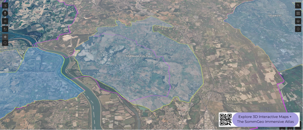
The undisputed flagship of the Southern Rhône, Châteauneuf-du-Pape sits on an elevated plateau between the Rhône River and the village of Bédarrides. The appellation is famous for its galets roulés (large, rounded stones deposited by the ancient Rhône), which retain heat during the day and radiate it back to the vines at night. But the soil story is more complex than the stones suggest: the plateau includes areas of red clay, sand, and limestone that produce markedly different expressions of Grenache. Thirteen grape varieties are traditionally permitted in the blend (eighteen by the current INAO count, which lists color mutations separately), though Grenache typically dominates at 60% to 80%. The plateau sits at roughly 80 to 130 meters (260 to 425 feet) above sea level, and the slight elevation above the river plain is visible in the 3D terrain, as are the boundaries where the stony plateau gives way to sandier soils.
The Dentelles de Montmirail: Gigondas and Vacqueyras
East of Orange, the jagged limestone peaks of the Dentelles de Montmirail create a dramatic backdrop and a natural shelter for the vineyards at their base. Gigondas occupies the slopes surrounding these peaks, with vineyards on a wide range of exposures from south- and west-facing lower slopes to cooler north- and northwest-facing sites at higher elevations. The altitude and the sheltering effect of the Dentelles give Gigondas wines more structure and freshness than the warmer valley floor. Vacqueyras, just to the south, sits on slightly lower ground with more alluvial gravel and clay, producing slightly rustic wines. In 3D, the Dentelles are unmistakable: their serrated ridgeline and the way vineyards wrap around their lower slopes are among the most visually striking features in this map.
Côtes du Rhône-Villages and Named Crus
Beyond the headline appellations, the Southern Rhône includes a network of named villages and crus that have gained recognition in recent decades. Rasteau (elevated terraces, fortified Grenache tradition), Cairanne (limestone plateau, increasingly serious reds), Beaumes-de-Venise (famous for Muscat but also producing still reds), and Vinsobres (higher altitude, cooler nights) have all earned their own AOC status. The broader Côtes du Rhône and Côtes du Rhône-Villages appellations cover the valley floor and lower hillsides, where Grenache-based blends range from everyday drinking to genuinely serious wines depending on site and producer.
New to 3D Fast Maps? Learn how to navigate 3D terrain, use elevation profiles, animate sunlight, and get the most from your map.
3D Fast Maps Guide →Ready to explore the Southern Rhône in full 3D? Join 200+ wine organizations already using SommGeo.
Start Your 15-Day Free Trial $5/month billed annually after trial · Cancel anytimeMap Usage & Permissions
Personal Use
You are welcome to use, download, and share the maps on this site for personal, educational, and non-commercial purposes. If you share a map, please credit SommGeo with a link back to sommgeo.com.
Commercial Use
Use of these maps for any commercial purpose, including websites, print publications, marketing materials, or any other commercial venture, is strictly prohibited without prior written permission.
To inquire about custom SommGeo platforms, maps, or commercial licensing, please contact greg@sommgeo.com.

