Victoria, NSW & Tasmania 3D Wine Map
Yarra Valley, Hunter Valley, Mornington Peninsula, and Tasmania in full 3D terrain.
This 3D Fast Map covers Australia’s eastern wine regions across three states with very different geographic personalities. Victoria packs a high number of distinct GIs into a relatively small area, driven by varied topography and coastal influence. New South Wales is well-known for the Hunter Valley, one of Australia’s oldest wine regions, where low elevation and warm, humid conditions produce a style unlike anything else in the country. Tasmania, separated by Bass Strait, offers a genuinely cool maritime climate that makes it a natural fit for sparkling wine, Pinot Noir, and Chardonnay. The terrain differences across these three states are striking, and 3D is the best way to see why they produce such different wines.
Unlock the Full SommGeo Toolkit
Gain exclusive access to our entire suite of premium features, including interactive Map Makers, immersive 3D Tours, high-resolution classic Maps, and advanced analytical tools.
Start Free TrialWhat You’ll Explore
This 3D Fast Map covers wine regions across Victoria, New South Wales, and Tasmania. Click any mapped region for detailed popup content covering grape varieties, classification details, and geographic specifics. Use the bookmarks to jump between key areas./p>
- Full 3D terrain across Victoria, NSW, and Tasmania wine regions
- Bookmarks for quick navigation to key areas within the map
- Elevation profile tool for measuring vineyard altitude and slope gradients
- Daylight and shadow animation to visualize aspect and sun exposure
Key Regions in Focus
Victoria: Yarra Valley and Mornington Peninsula
Victoria has more individual GIs than any other Australian state, packed into a compact area where small changes in elevation and coastal proximity create distinct growing conditions. The Yarra Valley, northeast of Melbourne, ranges from around 50 meters (164 ft) on the valley floor to over 400 meters (1,312 ft) in the Upper Yarra, producing everything from ripe Shiraz at the warmer, lower elevations to taut Pinot Noir and Chardonnay higher up. The Mornington Peninsula juts into Bass Strait south of Melbourne, where maritime influence keeps temperatures moderate and wind is a constant factor. Pinot Noir and Chardonnay dominate. Further north, Rutherglen and the King Valley offer completely different conditions: Rutherglen’s warm continental climate produces fortified Muscat and Topaque (Muscadelle) of a style found nowhere else in Australia.
New South Wales: Hunter Valley
The Hunter Valley sits at low elevation (roughly 60 to 150 meters / 197 to 492 ft) about 160 kilometers (99 miles) north of Sydney, and its warm, humid climate would seem an unlikely setting for fine wine. But the Brokenback Range to the west shelters the valley, while the region’s proximity to the coast brings afternoon cloud cover and moderating breezes that temper the heat during the growing season. The Hunter’s signature is Semillon, picked early at low sugar levels and bottled without oak, producing wines that seem simple in youth but develop complexity with a decade or more of bottle age. Shiraz is the main red, and Hunter Shiraz tends toward a medium-bodied, earthy style quite different from the Barossa or McLaren Vale.
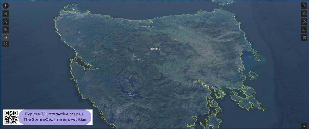
Tasmania
Tasmania is Australia’s coolest and most southerly wine-producing state, sitting between 41°S and 43°S across Bass Strait from the mainland. The island’s climate is genuinely maritime with cool temperatures and reliable rainfall. The Tamar Valley in the north, Coal River Valley near Hobart, and the East Coast each offer different mesoclimates shaped by the island’s rugged topography and varied coastal exposure. Pinot Noir and Chardonnay are the dominant varieties, and the state has become an increasingly important source for sparkling wine base. The cool conditions and long hang times produce fruit with natural acidity and flavor intensity.
New to 3D Fast Maps? Learn how to navigate 3D terrain, use elevation profiles, animate sunlight, and get the most from your map.
3D Fast Maps Guide →Ready to explore these wine regions in full 3D? Join 200+ wine organizations already using SommGeo.
Start Your 15-Day Free Trial $5/month billed annually after trial · Cancel anytimeMap Usage & Permissions
Personal Use
You are welcome to use, download, and share the maps on this site for personal, educational, and non-commercial purposes. If you share a map, please credit SommGeo with a link back to sommgeo.com.
Commercial Use
Use of these maps for any commercial purpose, including websites, print publications, marketing materials, or any other commercial venture, is strictly prohibited without prior written permission.
To inquire about custom SommGeo platforms, maps, or commercial licensing, please contact greg@sommgeo.com.

