Northeast Spain 3D Wine Map
Rioja, Priorat, Penedès, Navarra, Somontano, and the Basque Country in full 3D terrain.
Northeast Spain is where the country’s most celebrated wine regions sit, and the terrain explains why. The Ebro River valley, the foothills of the Pyrenees, the coastal ranges of Catalonia, and the green, Atlantic-facing slopes of the Basque Country create a patchwork of dramatically different growing conditions within a relatively compact area. Rioja and Priorat alone represent two entirely different philosophies of Spanish wine, shaped by geography that could not be more different. This map covers the DOs and DOCas of Northeast Spain with detailed popup data. The bookmarks are the best way to navigate: use them to fly between Rioja, Priorat, the Basque Country, and the other key zones rather than scrolling across the map. The layer controls let you filter by regional grouping.
Unlock the Full SommGeo Toolkit
Gain exclusive access to our entire suite of premium features, including interactive Map Makers, immersive 3D Tours, high-resolution classic Maps, and advanced analytical tools.
Start Free TrialWhat You’ll Explore
This 3D Fast Map covers the DOs and DOCas of Northeast Spain, from the Ebro valley through Catalonia to the Basque coast. Click any mapped region for detailed popup content covering grape varieties, classification details, and geographic specifics. Start with the bookmarks to fly between Rioja, Priorat, Penedès, the Basque Country, and other key zones. Then use the layer controls to filter by regional grouping.
- Northeast Spain’s DOs and DOCas mapped with detailed popup data
- Bookmarks to fly directly between Rioja, Priorat, the Basque Country, and more
- Toggleable layers to control which regional groupings are displayed
- Elevation profile tool for measuring the altitude contrasts across the region
- Daylight and shadow animation to visualize aspect and sun exposure
- Weather overlay to see how Atlantic, Mediterranean, and continental conditions interact
Key Regions in Focus
Rioja and Navarra
Rioja is Spain’s most famous wine region and one of only two to hold DOCa (Denominación de Origen Calificada) status. The region follows the Ebro River and divides into three zones: Rioja Alta (higher altitude, cooler, clay-limestone soils producing more structured, age-worthy Tempranillo), Rioja Alavesa (on the Basque side, chalky clay soils on south-facing slopes with more aromatic, elegant wines), and Rioja Oriental (formerly Rioja Baja, lower, warmer, more Mediterranean, producing fuller-bodied wines often from Garnacha). In 3D, the Ebro valley and the Sierra de Cantabria mountain range that shelters Rioja from Atlantic weather are clearly visible. Navarra, immediately to the northeast, shares similar terrain but with more altitude variation and a growing reputation for Garnacha-based wines.
Catalonia: Priorat, Penedès, and the Coast
Priorat is the other DOCa in Spain, and its geography is extreme. Steep, terraced hillsides of llicorella (black slate and quartz) produce tiny yields of Garnacha and Cariñena with extraordinary concentration. Vineyards sit at 100 to 700 meters (330 to 2,300 feet) in a series of small valleys radiating from the village of Gratallops. The 3D terrain makes the scale of these slopes and the isolation of the Priorat basin immediately clear. Penedès, closer to Barcelona, occupies gentler terrain between the coastal ranges and the Catalan interior, producing most of Spain’s Cava from Macabeo, Xarel·lo, and Parellada. Montsant, the DO that surrounds Priorat like a ring, offers similar slate soils at slightly lower altitude and lower prices.
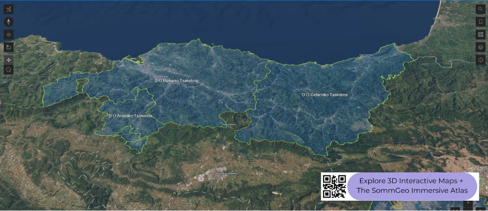
The Basque Country and Aragon
The Basque Country is the geographic opposite of everything further inland. The Txakoli DOs (Getariako Txakolina, Bizkaiko Txakolina, Arabako Txakolina) occupy steep, green, Atlantic-facing slopes where Hondarrabi Zuri produces crisp, low-alcohol, slightly effervescent whites in one of Spain’s coolest and wettest growing environments. The terrain is dramatic: vineyards on near-vertical hillsides above the Bay of Biscay, with rainfall exceeding 1,500 millimeters (59 inches) per year. Further south and inland, Aragon’s Somontano DO sits in the Pyrenean foothills at 350 to 650 meters (1,150 to 2,130 feet) on sandy and limestone soils, producing increasingly respected reds from both indigenous and international varieties.
New to 3D Fast Maps? Learn how to navigate 3D terrain, use elevation profiles, animate sunlight, and get the most from your map.
3D Fast Maps Guide →Ready to explore Northeast Spain in full 3D? Join 200+ wine organizations already using SommGeo.
Start Your 15-Day Free Trial $5/month billed annually after trial · Cancel anytimeMap Usage & Permissions
Personal Use
You are welcome to use, download, and share the maps on this site for personal, educational, and non-commercial purposes. If you share a map, please credit SommGeo with a link back to sommgeo.com.
Commercial Use
Use of these maps for any commercial purpose, including websites, print publications, marketing materials, or any other commercial venture, is strictly prohibited without prior written permission.
To inquire about custom SommGeo platforms, maps, or commercial licensing, please contact greg@sommgeo.com.

