Rest of USA 3D Wine Map
The Finger Lakes, Virginia, Texas, Lodi, and the emerging and established wine regions beyond the West Coast in full 3D terrain.
Wine is produced in all 50 states, but the regions that matter for sommeliers and serious professionals are scattered across the country in diverse and sometimes unexpected terrain. The Finger Lakes in upstate New York, the foothills of Virginia, the Texas Hill Country, and California’s Lodi each occupy distinct geographic niches with their own climate challenges and varietal strengths. This map brings these spread-out regions together with detailed popup data. The bookmarks are essential here: the regions on this map span thousands of miles, and the bookmarks will fly you directly between the Finger Lakes, Virginia, Texas, Lodi, and the other areas without manual scrolling across the continent. The layer controls let you change between shading and outlines.
Unlock the Full SommGeo Toolkit
Gain exclusive access to our entire suite of premium features, including interactive Map Makers, immersive 3D Tours, high-resolution classic Maps, and advanced analytical tools.
Start Free TrialWhat You’ll Explore
This 3D Fast Map covers the notable wine regions and AVAs across the United States outside of the North Coast, Central Coast, Columbia Valley, and Willamette Valley (which have their own dedicated maps). Click any mapped area for detailed popup content covering grape varieties, climate, and geographic specifics. The bookmarks are the way to navigate this map: the regions span the entire country, so use them to fly directly between the Finger Lakes, Virginia, Texas, Lodi, and other areas.
- Notable wine regions and AVAs across the USA mapped with detailed popup data
- Bookmarks to fly directly between the Finger Lakes, Virginia, Texas, Lodi, and more
- Elevation profile tool for measuring vineyard altitude and terrain gradients
- Daylight and shadow animation to visualize aspect and sun exposure
Key Regions in Focus
Finger Lakes, New York
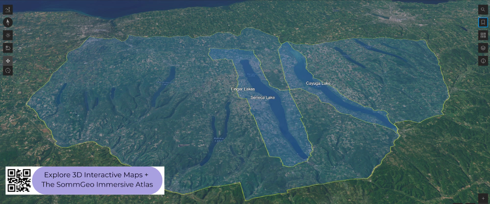
The Finger Lakes is the most important cool-climate wine region in the eastern United States and one of the country’s best sources of Riesling. Eleven long, narrow, glacially carved lakes create a lake-effect microclimate that moderates the harsh continental conditions of upstate New York. Seneca Lake, the deepest at over 600 feet (183 m), never freezes and provides the most significant temperature moderation, with its best vineyards on steep slopes facing the water at 800 to 1,000 feet (245 to 305 m). Keuka Lake and Cayuga Lake add further variation. The 3D terrain makes the depth and scale of these glacial lakes visible, and the daylight animation shows how the lake-facing slopes catch different light throughout the day. Use the bookmarks to fly here from the other regions.
Virginia and the Mid-Atlantic
Virginia is one of the most established wine states on the East Coast and the fifth-largest by production. The primary growing areas sit in the Blue Ridge foothills at 500 to 1,500 feet (150 to 460 m), where elevation provides the drainage and air circulation needed in a humid climate. The Monticello AVA around Charlottesville is the best-known zone, producing Viognier (Virginia’s signature white), Cabernet Franc, and Petit Verdot on red clay and granite. The Shenandoah Valley, between the Blue Ridge and Alleghenies, offers slightly cooler conditions. Hillside vineyards with good air drainage outperform valley-floor sites significantly, and the terrain makes these distinctions visible. The bookmarks take you between Virginia and the other mapped states.
Texas, Lodi, and Other Regions
The Texas Hill Country AVA, west of Austin, is the third-largest AVA in the country by area, with vineyards on limestone and caliche at 1,000 to 2,000 feet (305 to 610 m). The Texas High Plains AVA around Lubbock, at roughly 3,300 feet (1,005 m), provides the altitude and diurnal swings that produce much of the state’s best fruit. Lodi, in California’s Central Valley, is one of the country’s most productive regions and the historic center of old-vine Zinfandel, with sandy loam soils moderated by the Sacramento Delta breeze. The map also covers regions in Michigan, Arizona, Colorado, and other states where the industry is growing. The bookmarks make it easy to jump between all of these across the full map.
New to 3D Fast Maps? Learn how to navigate 3D terrain, use elevation profiles, animate sunlight, and get the most from your map.
3D Fast Maps Guide →Ready to explore America’s wine regions in full 3D? Join 200+ wine organizations already using SommGeo.
Start Your 15-Day Free Trial $5/month billed annually after trial · Cancel anytimeMap Usage & Permissions
Personal Use
You are welcome to use, download, and share the maps on this site for personal, educational, and non-commercial purposes. If you share a map, please credit SommGeo with a link back to sommgeo.com.
Commercial Use
Use of these maps for any commercial purpose, including websites, print publications, marketing materials, or any other commercial venture, is strictly prohibited without prior written permission.
To inquire about custom SommGeo platforms, maps, or commercial licensing, please contact greg@sommgeo.com.

