North Coast 3D Wine Map
Napa Valley, Sonoma County, Mendocino, Lake County, and the North Coast AVAs in full 3D terrain.
California’s North Coast covers Napa Valley, Sonoma County, Mendocino, and Lake County, and the terrain drives the differences between them. Two parallel mountain ranges (the Mayacamas and the Vaca) frame Napa Valley. Sonoma’s appellations spread from fog-cooled coastal ridges to warm inland benchlands. Mendocino and Lake County add higher elevations and volcanic soils further north. The geography is dense with nested and overlapping AVAs, and the relationships between them only make sense in 3D. This map covers the North Coast AVAs with detailed popup data. The bookmarks are the best way to navigate: use them to fly between Napa, Sonoma, Mendocino, and Lake County. Use the arrow keys on the popups to explore overlapping AVAs.
Unlock the Full SommGeo Toolkit
Gain exclusive access to our entire suite of premium features, including interactive Map Makers, immersive 3D Tours, high-resolution classic Maps, and advanced analytical tools.
Start Free TrialWhat You’ll Explore
This 3D Fast Map covers the AVAs of California’s North Coast. Click any mapped AVA for detailed popup content covering grape varieties, classification details, and geographic specifics. Start with the bookmarks to fly between Napa Valley, Sonoma County, Mendocino, and Lake County. Then use the layer controls to filter by AVA grouping and the elevation profile tool to trace the mountain ranges and valley floors.
- North Coast AVAs mapped with detailed popup data
- Bookmarks to fly directly between Napa, Sonoma, Mendocino, and Lake County
- Toggleable layers to control which AVA groupings are displayed
- Elevation profile tool for measuring mountain passes and valley floor altitudes
- Daylight and shadow animation to visualize aspect and sun exposure
- Weather overlay to see how Pacific fog and coastal influence interact with terrain
Key Regions in Focus
Napa Valley
Napa Valley is roughly 30 miles (48 km) long and 5 miles (8 km) wide, framed by the Mayacamas to the west and the Vaca Mountains to the east. The valley floor rises from sea level at Carneros (cool, fog-influenced) to around 400 feet (120 m) at Calistoga (warmer, sheltered). Seventeen nested sub-AVAs reflect the diversity: Oakville and Rutherford produce benchmark Cabernet Sauvignon on the benchland, Howell Mountain and Spring Mountain District add altitude and volcanic soils, and Stags Leap District on the Vaca side occupies a specific exposure that moderates afternoon heat. In 3D, the narrow valley profile and the mountain walls that contain it are immediately clear. Use the bookmarks to fly the length of the valley and compare sub-AVAs.
Sonoma County
Sonoma is geographically larger and more varied than Napa, and the terrain tells the story. The Russian River Valley, shaped by the river’s path through the coastal hills, channels fog from the Pacific directly into the vineyards, creating ideal conditions for Pinot Noir and Chardonnay. The Sonoma Coast AVA covers a vast, fog-cooled area along the ocean, with the Petaluma Gap (a wind gap in the coastal hills) producing some of the region’s most site-driven Pinot Noir. Dry Creek Valley, further inland, is warmer and sheltered, producing Zinfandel and Cabernet Sauvignon on benchland soils. Alexander Valley, at the northern end, adds warmer valley-floor conditions for Cabernet.
Mendocino and Lake County
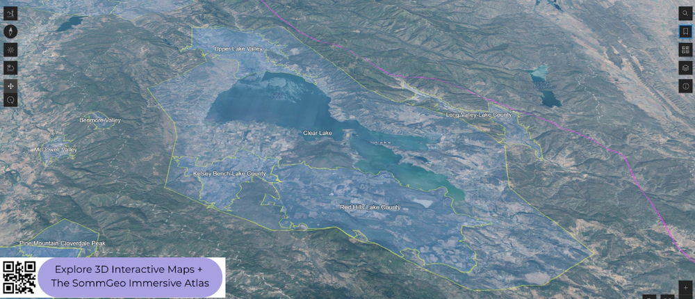
North of Sonoma, Mendocino and Lake County offer altitude and distinct geology that set them apart. Mendocino’s soils are largely alluvial and marine sedimentary, while Lake County is defined by the volcanic terrain surrounding Clear Lake and Mount Konocti. Anderson Valley, in western Mendocino, is a narrow, fog-cooled valley producing high-quality sparkling wine, Pinot Noir, and Gewürztraminer. The inland Mendocino Ridge AVA (defined by elevation rather than a continuous boundary, covering vineyards above 1,200 feet / 365 m) and Redwood Valley add warmer, hillside conditions. Lake County, centered on Clear Lake at roughly 1,300 feet (400 m), is one of the highest wine-growing areas in the North Coast, with volcanic soils (including the Red Hills Lake County AVA on volcanic red clay) and intense sunshine moderated by altitude. The 3D terrain makes Lake County’s volcanic basin and the Mayacamas separation from Napa immediately visible. The bookmarks take you between these northern areas and the more familiar Napa and Sonoma zones to the south.
New to 3D Fast Maps? Learn how to navigate 3D terrain, use elevation profiles, animate sunlight, and get the most from your map.
3D Fast Maps Guide →Ready to explore the North Coast in full 3D? Join 200+ wine organizations already using SommGeo.
Start Your 15-Day Free Trial $5/month billed annually after trial · Cancel anytimeMap Usage & Permissions
Personal Use
You are welcome to use, download, and share the maps on this site for personal, educational, and non-commercial purposes. If you share a map, please credit SommGeo with a link back to sommgeo.com.
Commercial Use
Use of these maps for any commercial purpose, including websites, print publications, marketing materials, or any other commercial venture, is strictly prohibited without prior written permission.
To inquire about custom SommGeo platforms, maps, or commercial licensing, please contact greg@sommgeo.com.

