Austria Wine Map Maker: Build Custom Maps
Profile the Wachau’s terraced gneiss slopes, simulate daylight across the Danube, annotate DAC boundaries for exam prep. This is Austrian wine geography you can work with.
The Austria Wine Map Maker gives you a professional GIS workspace covering every DAC region in the country. Austria packs an extraordinary amount of geographic complexity into a relatively compact wine-producing footprint, nearly all of it concentrated in the eastern third of the country where the Alps give way to the Pannonian plain. The result is a collision of climatic influences that creates wildly different growing conditions within short distances. The Wachau’s steep, terraced Danube gorge vineyards. The Pannonian heat of Burgenland’s Neusiedlersee. The impossibly steep Sauvignon Blanc slopes of Südsteiermark along the Slovenian border. A flat map can’t tell these stories. Switch between 2D and 3D to see how the Danube carved through primary rock to create the Wachau. Run an elevation profile from the Kamptal’s Heiligenstein down to the river. Turn labels off entirely and quiz yourself on DAC locations. This is Austrian wine geography you build, annotate, and interrogate, not just read about. And every mapped region includes detailed popup content covering grape varieties, DAC classification tiers, climate profiles, soil types, a sommelier-level reference built directly into the map.
Unlock the Full SommGeo Toolkit
Gain exclusive access to our entire suite of premium features, including interactive Map Makers, immersive 3D Tours, high-resolution classic Maps, and advanced analytical tools.
Start Free TrialWhat You Can Build
The Austria Map Maker is an interactive workspace, not a static reference, and the real depth is in what each region reveals. Click on any mapped DAC and a comprehensive info panel opens with sommelier-level content: grape varieties, DAC classification tiers and rules, climate and geographic profiles, soil composition, the viticultural specifics that define each region. Whether you’re reading about the Wachau’s gneiss-driven Riesling terraces, the Pannonian heat shaping Blaufränkisch in Mittelburgenland, or the Sauvignon Blanc sites of Südsteiermark on opok soils, every mapped region carries this level of built-in intelligence. Beyond the content, every tool in the bottom toolbar opens a different way to interrogate Austrian wine geography.
- In-depth region profiles: Click any mapped area for detailed content covering varieties, DAC rules, geology, climate
- 3D / 2D Toggle: Switch between flat overview and immersive 3D terrain to see how the Danube carved through gneiss bedrock to create the Wachau’s steep vineyard terraces
- Daylight Simulator: Set any date and time to model sun position and shadow cast, critical for understanding aspect on the Wachau’s south-facing terraces and Styria’s steep slopes
- Measure Tool: Draw lines to measure distances and generate elevation profiles. Trace from the Heiligenstein down to the Danube or across the Leithaberg ridge
- Sketch & Annotate: Drop pins, draw shapes, and add text labels to build custom study maps or presentation visuals directly on the map (2D only)
- Legend & Map Layers: Toggle DAC boundaries on and off, turn labels off for blind self-testing, and use the Interactive Legend to isolate individual regions
Tools in Action
Each tool in the Map Maker pairs with a specific geographic story that’s hard to tell any other way. Here’s how wine professionals are using them across Austria’s regions.
🏔️ Elevation Profile + Wachau Terraces
Draw a line from the Danube riverbank straight up through the Wachau’s terraced vineyards to the forested ridgeline above. The Measure tool generates an elevation cross-section that reveals why lower loess-covered slopes favor Grüner Veltliner while the steepest, most exposed gneiss terraces higher up produce the most concentrated Riesling; the soil gets thinner, drainage increases, and vines root directly into primary rock. This is the physical logic behind the Steinfeder-Federspiel-Smaragd quality hierarchy made visible in a single line.
☀️ Daylight Simulator + Südsteiermark
Set the Daylight tool to a midsummer afternoon in Südsteiermark and watch how shadow falls across the steep, south-facing vineyard slopes along the Slovenian border. The extreme topography means that aspect and exposure vary dramatically from one hillside to the next, and the Daylight simulator reveals which slopes get the full afternoon sun and which fall into shadow early. Understanding these differences helps explain why certain Ried (single vineyard) sites command premium prices.
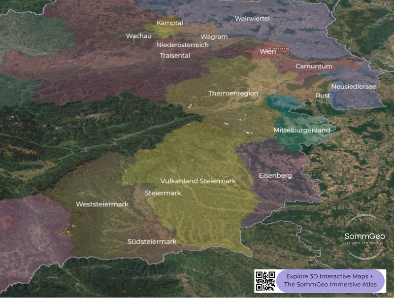
🌐 3D Mode + The Danube Valley
Austria’s Danubian wine regions (Wachau, Kremstal, Kamptal, Traisental, Wagram) only make full sense in 3D. You’ll see how the Danube carved a gorge through the Bohemian Massif’s gneiss to create the Wachau, how the Kamp River valley opens into the Kamptal with the legendary Heiligenstein rising above Langenlois, and how the terrain flattens dramatically east of Krems as you enter the vast Weinviertel, Austria’s largest DAC and the heartland of peppery Grüner Veltliner.
✏️ Sketch + Exam Prep & Self-Study
Studying for the WSET Diploma or Court of Master Sommeliers? Switch to the outline basemap, turn labels off, and test yourself on DAC locations. Then use the Sketch tools to annotate. Drop pins on key villages, draw boundary highlights, add text labels with grape variety associations. Save the custom view for revision. Austria’s DAC system rewards geographic precision, and building maps by hand is the fastest way to internalize it.
Austria’s Wine Geography
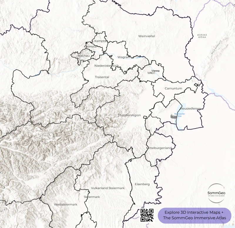
Austria’s wine-producing areas are overwhelmingly concentrated in the eastern third of the country; the western two-thirds are dominated by the Alps, which effectively push viticulture into a compact but intensely varied corridor running from the Danube Valley south through Burgenland and into the hills of Steiermark (Styria). What makes this small footprint so interesting is the collision of climatic influences. Cool Atlantic air masses push in from the west along the Danube, warm Pannonian continental air radiates from the Hungarian plain to the east, and the last foothills of the Alps create dramatic topographic variation wherever these systems meet.
The DAC (Districtus Austriae Controllatus) system (Austria’s answer to the French appellation model) organizes this geography into origin-defined quality categories. Introduced in 2002 with the Weinviertel as the first designated region, the system now covers the country’s major wine-growing areas. Each DAC defines not just a geographic boundary but a style identity: specific grape varieties and quality tiers tied to the character of the place. The three-tier pyramid (Gebietswein (regional wine), Ortswein (village wine), and Riedenwein (single vineyard wine)) adopted by many DACs mirrors Burgundy’s logic of increasingly precise geographic origin indicating increasing quality and site specificity.
Niederösterreich (Lower Austria) is the powerhouse, accounting for roughly 60% of the country’s vineyard area across eight distinct regions. Burgenland, along the Hungarian border and wrapped around Lake Neusiedl, is Austria’s red wine heartland; the warm Pannonian climate delivers the ripeness that Blaufränkisch and Zweigelt need. And Steiermark in the southeast, with just 10% of Austria’s vineyards, produces aromatic whites of extraordinary precision on steep slopes that rival the gradient of any vineyard in Europe.
Key Regions to Build
The Wachau: Austria’s Most Famous Vineyard Landscape
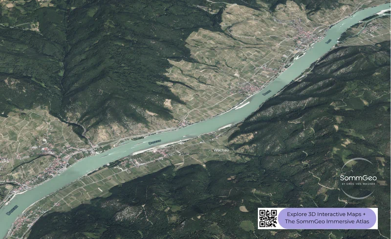
The Wachau is one of the great vineyard landscapes of the world. A UNESCO World Heritage Site, this 35-kilometer stretch of the Danube between Melk and Krems carves through the Bohemian Massif’s ancient gneiss bedrock, creating steep, south-facing terraced vineyards that monks built by hand in the Middle Ages, dry-stone walls without mortar that still stand and still function. The 3D satellite view in the Map Maker is the best way to grasp the sheer verticality of it.
Two grape varieties dominate: Grüner Veltliner on the loess-covered lower slopes where deeper soils retain moisture, and Riesling on the steepest upper terraces where vines root directly into gneiss and granitic primary rock. The Wachau’s own quality classification (Steinfeder (light, up to 11.5% ABV), Federspiel (medium, 11.5–12.5%), and Smaragd (powerful, 12.5%+)) maps elegantly onto this elevation gradient. The top Smaragd wines from producers like F.X. Pichler, Hirtzberger, Knoll, Alzinger, and Prager are among the finest dry whites produced anywhere and capable of aging. Use the Daylight tool to see how the south-facing terraces capture full sun while the river below moderates temperature, the physical mechanism behind the Wachau’s remarkable concentration and acidity balance.
Kamptal & Kremstal: The Danubian Neighbors
Immediately east of the Wachau, the Kamptal and Kremstal DACs produce Grüner Veltliner and Riesling of comparable quality but with subtly different expressions. The Kamptal’s defining feature is the Heiligenstein, a 270-million-year-old outcrop of Permian sandstone with volcanic elements that’s genuinely unique in Austrian geology. The name doesn’t mean “holy stone”; it’s derived from “hellish,” a reference to the scorching sun exposure on its steep southern slope. Riesling from the Heiligenstein is mineral-driven, powerful, and built to age. Langenlois, at the foot of the hill, is Austria’s largest wine-producing town, home to estates like Bründlmayer, Schloss Gobelsburg, and Loimer.
Kremstal, centered on the city of Krems at the eastern end of the Wachau, shares many of the same soil types (gneiss, loess, gravel) but with a slightly warmer, more Pannonian-influenced climate. The wines tend toward a touch more body and generosity compared to the Wachau’s taut precision. Both DACs use the same three-tier origin pyramid (Gebietswein, Ortswein, Riedenwein), and the Map Maker’s elevation profile tool is perfect for comparing the terrain profiles of all three Danubian regions side by side.
Burgenland: Blaufränkisch Country
Burgenland is where Austria makes its most serious red wines. The warm Pannonian climate generated by the flat Hungarian plain delivers the extended ripening period that Blaufränkisch and Zweigelt need. Six DACs carve up the region: Neusiedlersee (Zweigelt-focused, surrounding the shallow lake), Leithaberg (both whites from Pinot Blanc and Chardonnay, and reds from Blaufränkisch on limestone and slate soils of the Leitha range), Rosalia (Austria’s newest red and rosé DAC), Mittelburgenland (the Blaufränkisch heartland on heavy clay and schist soils), Eisenberg (elegant, peppery Blaufränkisch on iron-rich slate at the southern tip of Burgenland), and Ruster Ausbruch (historically renowned, botrytized sweet wines from the free city of Rust).
Lake Neusiedl itself is a critical geographic feature: Europe’s second-largest steppe lake, shallow enough that it moderates local temperatures and generates the autumn mists that make Burgenland one of the world’s great regions for botrytized dessert wines. These mists are the engine behind the Ruster Ausbruch DAC on the western shore, as well as the extraordinary Beerenauslese and Trockenbeerenauslese from Neusiedlersee to the east, particularly from Welschriesling. The 3D view shows how the flat terrain around the lake contrasts sharply with the Leithaberg hills to the west and the Eisenberg’s iron-rich slopes to the far south.
Steiermark (Styria): The Aromatic South
Steiermark may only account for 10% of Austria’s vineyards, but its wines punch far above that weight class. Three DACs divide the region: Südsteiermark, Vulkanland Steiermark, and Weststeiermark. Südsteiermark is the star, a tiny, rocky corridor of impossibly steep south-facing slopes along the Slovenian border where Sauvignon Blanc reaches world-class complexity. The best Südsteiermark Sauvignon Blancs from producers like Tement rival the finest expressions from anywhere in the world, with a mineral precision and site specificity that’s unique.
Vulkanland Steiermark, to the east, sits on volcanic soils and produces an impressive range of aromatic whites: Gelber Muskateller, Traminer, Pinot Blanc, and Morillon (the Styrian name for Chardonnay). Weststeiermark is the smallest of the three and home to the Schilcher rosé, a bracingly dry, spicy pink wine made exclusively from Blauer Wildbacher, found virtually nowhere else on earth. The 3D views of Südsteiermark in the Map Maker are some of the most dramatic vineyard landscapes on the platform; the gradient on these slopes is genuinely startling.
New to the Map Makers? Explore all the tools, tips, and features in our complete walkthrough.
Map Maker Guide →Ready to build your own Austrian wine maps? Join 200+ wine organizations already using SommGeo.
Start Your 15-Day Free Trial $5/month billed annually after trial · Cancel anytimePlease let us know what you think in the form below. Thanks!

