Austria 3D Wine Map
Wachau, Kamptal, Kremstal, Burgenland, and Steiermark in full 3D terrain.
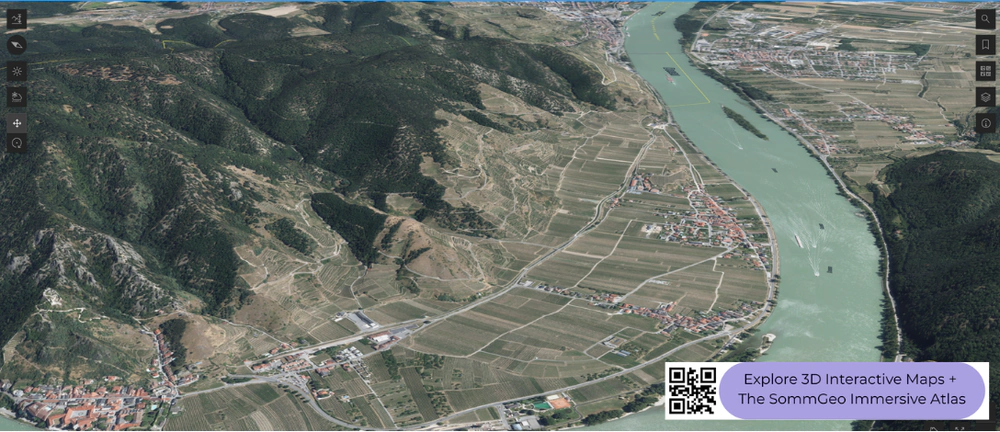
Austrian wine is a story of rivers, slopes, and the tension between Alpine and Pannonian climates. The Danube carves through Lower Austria creating the steep, terraced vineyards of the Wachau and the gentler loess hills of Kamptal and Kremstal. To the east, the flat plains around Lake Neusiedl in Burgenland shift into a warmer, continental pattern suited to red wines and botrytis-affected sweets. In the south, Steiermark (Styria) brings cool, steep hillside viticulture with a different character entirely. This 3D Fast Map covers all of Austria’s wine-producing regions, and the terrain differences between them are immediately apparent when you tilt the view.
Unlock the Full SommGeo Toolkit
Gain exclusive access to our entire suite of premium features, including interactive Map Makers, immersive 3D Tours, high-resolution classic Maps, and advanced analytical tools.
Start Free TrialWhat You’ll Explore
This 3D Fast Map covers all of Austria’s wine-producing regions, from the Danube-facing slopes of Lower Austria through the Pannonian plains of Burgenland to the steep hills of Steiermark in the south. Click any mapped region for detailed popup content covering grape varieties, classification details, and geographic specifics. Use the bookmarks to jump between key areas and the layer controls to toggle different region groupings.
- Full 3D terrain of Austria’s wine regions from the Danube to Steiermark
- Bookmarks for quick navigation to key areas within the map
- Toggleable layers to control which region groupings are displayed
- Elevation profile tool for measuring vineyard altitude and slope gradients
- Daylight and shadow animation to visualize aspect and sun exposure
- Weather overlay to see how atmospheric conditions interact with terrain
Key Regions in Focus
Wachau
The Wachau is a 33-kilometer (20.5-mile) stretch of the Danube Valley west of Krems where the river cuts through the Bohemian Massif, creating steep, south-facing terraced slopes of primary rock: gneiss, granite, and mica schist. Vineyards sit between roughly 200 and 450 meters (656 and 1,476 ft), and the combination of steep gradients, reflected heat from the river, and sheltered south-facing aspect creates conditions that allow Grüner Veltliner and Riesling to ripen fully despite the northern latitude. The Wachau joined the DAC system in 2020 but retained its own classification terminology: Steinfeder (light, fresh), Federspiel (medium-bodied), and Smaragd (full, dry, from the ripest fruit), all sitting within the broader Wachau DAC framework. The 3D terrain makes the valley’s narrow, gorge-like geography immediately clear.
Kamptal, Kremstal, and Wagram
East of the Wachau, the Danube Valley opens into gentler terrain where thick loess deposits dominate the soil profile. Kamptal, centered on the Kamp River tributary, and Kremstal, surrounding the town of Krems, are both DAC regions focused on Grüner Veltliner and Riesling. The loess soils here can run 20 meters (66 ft) deep in places, retaining water well and producing wines that tend toward a rounder, broader profile compared to the mineral-driven Wachau bottlings from primary rock. Wagram, further east on the Danube’s north bank, sits on a distinctive loess terrace and shares a similar profile. These regions are where the bulk of Austria’s Grüner Veltliner production sits, spanning styles from fresh and peppery to full and age-worthy.
Burgenland
Burgenland is Austria’s eastern frontier, bordering Hungary and centered on Lake Neusiedl (Neusiedlersee). The geography here is a sharp contrast to the Danube Valley: flat, warm, and influenced by the shallow lake’s moderating effect and the humid conditions it creates. The Neusiedlersee DAC, on the lake’s eastern shore, is focused on Zweigelt and on botrytis-affected sweet wines, where autumn mists rising off the lake encourage noble rot on varieties like Welschriesling and Chardonnay. Mittelburgenland, further south, is Blaufränkisch country on iron-rich clay soils. The Leithaberg DAC, on the slopes of the Leitha Mountains along the lake’s western shore, produces both whites (Grüner Veltliner, Chardonnay, Pinot Blanc) and reds (Blaufränkisch) with a distinct mineral stamp from its limestone and schist soils.
New to 3D Fast Maps? Learn how to navigate 3D terrain, use elevation profiles, animate sunlight, and get the most from your map.
3D Fast Maps Guide →Ready to explore Austria’s wine regions in full 3D? Join 200+ wine organizations already using SommGeo.
Start Your 15-Day Free Trial $5/month billed annually after trial · Cancel anytimeMap Usage & Permissions
Personal Use
You are welcome to use, download, and share the maps on this site for personal, educational, and non-commercial purposes. If you share a map, please credit SommGeo with a link back to sommgeo.com.
Commercial Use
Use of these maps for any commercial purpose, including websites, print publications, marketing materials, or any other commercial venture, is strictly prohibited without prior written permission.
To inquire about custom SommGeo platforms, maps, or commercial licensing, please contact greg@sommgeo.com.

