Greece 3D Wine Map
Santorini, Naoussa, Nemea, Crete, and Greece’s PDO wine regions in full 3D terrain.
Greece is one of the most geographically diverse wine countries in Europe. Vineyards sit on volcanic islands in the Aegean, on mountain slopes in Macedonia and the Peloponnese, and across the hillsides of Crete at the southeastern edge of the continent. The terrain ranges from sea level to well over 700 meters (2,300 feet), and the interplay of altitude, maritime exposure, and continental influence shapes how indigenous varieties like Assyrtiko, Xinomavro, and Agiorgitiko express themselves from region to region. This map covers Greece’s PDO wine regions with detailed popup data on each. Use the layer controls to filter by region grouping and the elevation profile tool to measure the altitude differences that define Greek viticulture.
Unlock the Full SommGeo Toolkit
Gain exclusive access to our entire suite of premium features, including interactive Map Makers, immersive 3D Tours, high-resolution classic Maps, and advanced analytical tools.
Start Free TrialWhat You’ll Explore
This 3D Fast Map covers Greece’s PDO wine regions across the mainland and islands. Click any mapped region for detailed popup content covering grape varieties, classification details, and geographic specifics. Use the layer controls to toggle different regional groupings on and off and the elevation profile tool to trace the altitude gradients that separate highland from coastal viticulture.
- Greece’s PDO wine regions mapped across the mainland and islands
- Elevation profile tool for measuring vineyard altitude and slope gradients
- Daylight and shadow animation to visualize aspect and sun exposure
- Detailed popup data for every mapped PDO region
Key Regions in Focus
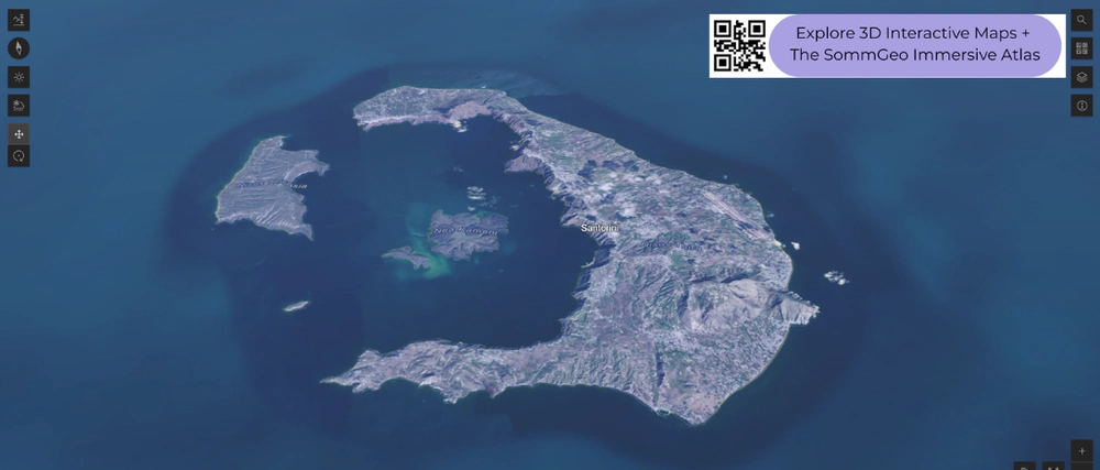
Santorini
Santorini is unlike any other wine region in the world. The island is the rim of a submerged volcanic caldera, and the vineyards grow on volcanic ash, pumice, and mineral-rich soils that retain almost no water. Rainfall is minimal, and the fierce Aegean winds make trellising impractical, so vines are trained in the kouloura (basket) system, coiled close to the ground to protect the fruit. Assyrtiko is the dominant grape, producing whites with striking acidity, salinity, and minerality despite the warm Mediterranean climate. The volcanic soils have never been touched by phylloxera, and many vines are ungrafted and over a century old. In 3D, the caldera’s scale and the exposed terrain where these vines survive become visceral in a way that flat maps and photographs cannot convey.
Northern Greece: Naoussa and Macedonia
Northern Greece is the country’s most important region for age-worthy red wines. Naoussa, on the southeastern slopes of Mount Vermion in Macedonia, is the home of Xinomavro, a grape with high acidity, firm tannins, and aromatic complexity often compared to Nebbiolo. Vineyards sit at 150 to 400 meters (490 to 1,310 feet) on clay and limestone soils, with a continental climate that gives the wines real structure and aging potential. Nearby Amyndeo (spellings vary), at even higher elevation around 620 meters (2,035 feet), produces lighter, more aromatic expressions of Xinomavro along with notable sparkling wines. The elevation profile tool is useful here for tracing the altitude differences between these Macedonian appellations.
The Peloponnese and Crete
Nemea, in the northeastern Peloponnese, is the largest red wine PDO in Greece and the center for Agiorgitiko, a red grape that produces a wide range of styles depending on altitude. Lower vineyard sites around 250 meters (820 feet) tend toward richer, more fruit-forward wines, while higher plantings above 600 meters (1,970 feet) in the Asprokampos area yield wines with more freshness and structure. Further south, Crete is experiencing a quiet renaissance with indigenous varieties like Vidiano and Kotsifali grown on mountainous terrain that reaches well above 500 meters (1,640 feet). The 3D terrain makes Crete’s surprising scale and mountain viticulture immediately visible.
New to 3D Fast Maps? Learn how to navigate 3D terrain, use elevation profiles, animate sunlight, and get the most from your map.
3D Fast Maps Guide →Ready to explore Greece’s wine regions in full 3D? Join 200+ wine organizations already using SommGeo.
Start Your 15-Day Free Trial $5/month billed annually after trial · Cancel anytimeMap Usage & Permissions
Personal Use
You are welcome to use, download, and share the maps on this site for personal, educational, and non-commercial purposes. If you share a map, please credit SommGeo with a link back to sommgeo.com.
Commercial Use
Use of these maps for any commercial purpose, including websites, print publications, marketing materials, or any other commercial venture, is strictly prohibited without prior written permission.
To inquire about custom SommGeo platforms, maps, or commercial licensing, please contact greg@sommgeo.com.

