Loire Valley 3D Wine Map
Sancerre, Pouilly-Fumé, Vouvray, Chinon, Muscadet, and the full length of France’s longest wine river.
The Loire is France’s longest river at roughly 1,000 kilometers (620 miles), and its wine regions stretch nearly the entire navigable length, from the Atlantic coast near Nantes to the Central Vineyards around Sancerre and Pouilly-Fumé far inland. What makes the Loire compelling in 3D is the way climate shifts from west to east as Atlantic influence fades: maritime at the mouth, increasingly continental toward the center of the country. The geology changes too, from the gneiss and granite of the Pays Nantais through the tuffeau limestone of Anjou and Touraine to the Kimmeridgian limestone and silex of the Central Vineyards. Three primary white grapes track these shifts: Melon de Bourgogne in the west, Chenin Blanc through the middle, and Sauvignon Blanc in the east.
Unlock the Full SommGeo Toolkit
Gain exclusive access to our entire suite of premium features, including interactive Map Makers, immersive 3D Tours, high-resolution classic Maps, and advanced analytical tools.
Start Free TrialWhat You’ll Explore
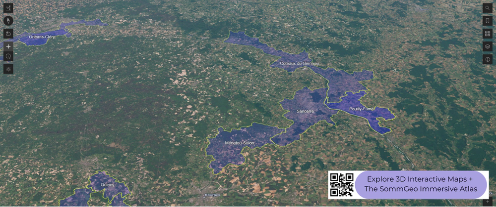
This 3D Fast Map covers the Loire Valley’s appellations from the Pays Nantais at the Atlantic coast through Anjou-Saumur and Touraine to the Central Vineyards around Sancerre. Click any mapped appellation for detailed popup content covering grape varieties, classification details, and geographic specifics. Use the bookmarks to jump between key areas and the layer controls to toggle different appellation groupings.
- Full 3D terrain of the Loire Valley from the Atlantic to the Central Vineyards
- Bookmarks for quick navigation to key areas within the map
- Toggleable layers to control which appellation groupings are displayed
- Elevation profile tool for measuring vineyard altitude and slope gradients
- Daylight and shadow animation to visualize aspect and sun exposure
- Weather overlay to see how atmospheric conditions interact with terrain
Key Regions in Focus
Pays Nantais and Anjou-Saumur
At the western end, the Pays Nantais sits closest to the Atlantic, where Melon de Bourgogne produces Muscadet on gneiss, granite, and gabbro soils. The cru communaux system (Clisson, Gorges, Le Pallet, and others) distinguishes specific terroirs within the larger Muscadet Sèvre et Maine appellation, each with minimum lees-aging requirements. Moving upstream, Anjou-Saumur is Chenin Blanc territory in all its forms: the dry, sweet, and sparkling wines of Savennières, Coteaux du Layon, Quarts de Chaume, Bonnezeaux, and Saumur Brut all come from Chenin grown on schist and tuffeau limestone. The tuffeau caves carved into the hillsides along the Loire provide natural cellaring conditions for the region’s traditional-method sparkling wines. Cabernet Franc produces the reds of Saumur-Champigny.
Touraine
Touraine straddles the middle Loire around Tours, where the Cher, Indre, and Vienne tributaries join the main river. Vouvray and Montlouis-sur-Loire face each other across the Loire, both producing Chenin Blanc in dry, demi-sec, moelleux, and sparkling styles, but from different bank exposures and slightly different tuffeau limestone profiles. South of the Loire, Chinon and Bourgueil (including Saint-Nicolas-de-Bourgueil) are the reference points for Loire Cabernet Franc: medium-bodied, aromatic reds with the fresh, herbal character that distinguishes Loire Cab Franc from warmer-climate expressions. The terrain here is gently undulating, and the tributary valleys create sheltered mesoclimates visible in the 3D map.
Central Vineyards
The Central Vineyards sit far inland around the upper Loire, where the climate is decisively continental and Sauvignon Blanc is the dominant grape. Sancerre occupies a series of hills on the west bank of the Loire, with three principal soil types: terres blanches (Kimmeridgian marl), caillottes (Oxfordian limestone, pebbly and well-drained), and silex (clay laced with flint). The soil profile shifts broadly from west to east across the appellation, and most producers blend across soil types rather than bottling them separately. Pouilly-Fumé faces Sancerre across the river on the east bank, also on Kimmeridgian limestone with significant silex deposits. The ‘fumé’ in the name refers either to the flinty, smoky quality of the wine or to the grey bloom on ripe Sauvignon Blanc grapes, depending on which local you ask. Menetou-Salon, Quincy, and Reuilly round out the Central Vineyards with similar varieties in slightly different settings.
New to 3D Fast Maps? Learn how to navigate 3D terrain, use elevation profiles, animate sunlight, and get the most from your map.
3D Fast Maps Guide →Ready to explore the Loire Valley in full 3D? Join 200+ wine organizations already using SommGeo.
Start Your 15-Day Free Trial $5/month billed annually after trial · Cancel anytimeMap Usage & Permissions
Personal Use
You are welcome to use, download, and share the maps on this site for personal, educational, and non-commercial purposes. If you share a map, please credit SommGeo with a link back to sommgeo.com.
Commercial Use
Use of these maps for any commercial purpose, including websites, print publications, marketing materials, or any other commercial venture, is strictly prohibited without prior written permission.
To inquire about custom SommGeo platforms, maps, or commercial licensing, please contact greg@sommgeo.com.

