
South Africa Wine Map Maker: Build Your Own Interactive Map
Decomposed granite in Stellenbosch, shale in Walker Bay, the cold Benguela Current shaping everything. South Africa’s Cape Winelands demand a tool that lets you see the geology and geography driving its wines.
South Africa’s Wine of Origin system encompasses over 30 districts and more than 100 wards, nearly all of them packed into the southwestern corner of the Western Cape within about 200 kilometers (124 miles) of Cape Town. That kind of density, combined with some of the oldest geological soils on the planet (we’re talking 500+ million years) and the competing influences of two oceans, makes this one of the most geographically complex wine countries. The South Africa Map Maker gives you a fully interactive workspace to study all of it. Switch between satellite imagery, 3D terrain relief, Light Gray Canvas, and other basemaps to visualize how mountains like the Simonsberg create rain shadows, how the Hemel-en-Aarde Valley funnels cool maritime air inland from Walker Bay, and why Stellenbosch alone contains more than 50 distinct soil types across its eight wards. Measure distances from Constantia to Elim. Fly over Franschhoek’s mountain-ringed valley in 3D. Drop placemarks on producers you’re studying. This is your workspace. Build the map you need. Every mapped region includes detailed popup content covering grape varieties, climate profiles, soil types, viticulture, a sommelier-level reference built directly into the map.
Unlock the Full SommGeo Toolkit
Gain exclusive access to our entire suite of premium features, including interactive Map Makers, immersive 3D Tours, high-resolution classic Maps, and advanced analytical tools.
Start Free TrialFree to learn from. Credit when you share it.
Studying for an exam or just exploring on your own? It’s all yours, no credit needed. But if a map is going to be seen by others, used to teach, or put to any commercial use, we’d ask that you credit it prominently as Made with SommGeo Map Maker.
Building something bigger? We design licensed and co-branded maps for teams, associations, importers, and producers. Get in touch.
What You’ll Explore
The real depth of the South Africa Map Maker is in what each region reveals. Click on any mapped district or ward and a comprehensive info panel opens with sommelier-level content: dominant grape varieties, climate and geographic profiles, soil composition, the viticultural specifics that define each area. Whether you’re reading about Stellenbosch’s decomposed granite and its role in world-class Cabernet, the Swartland’s old-bush-vine Chenin Blanc on schist, or the maritime influence funneling cool air through the Hemel-en-Aarde corridor, every mapped region carries this level of built-in intelligence. Beyond the content, toggle between satellite imagery and 3D terrain, switch to Light Gray Canvas to isolate ward boundaries, and measure distances across the Cape Winelands.
- All WO geographical units, regions, districts, and wards across the Western Cape and beyond
- In-depth region profiles for every mapped area: varieties, soils, climate
- 40 basemaps: satellite imagery, 3D terrain relief, Light Gray Canvas, topographic, and more
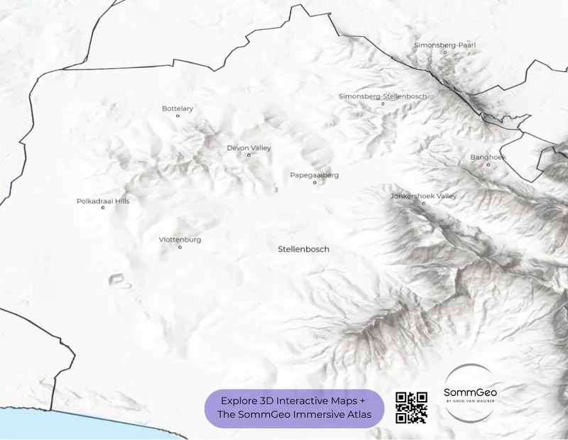
- Stellenbosch’s eight wards (Banghoek, Bottelary, Devon Valley, Jonkershoek Valley, Papegaaiberg, Polkadraai Hills, Simonsberg-Stellenbosch, and Vlottenburg) individually mapped
- Walker Bay’s Hemel-en-Aarde trio: Valley, Upper Valley, and Ridge wards visible with coastal proximity
- Measurement and placemark tools for building custom study materials and presentation maps


Geography That Shapes South African Wine
South Africa’s viticultural identity is inseparable from two powerful geographic forces: mountains and ocean currents. The Cape Fold Belt (a series of parallel mountain ranges running roughly east-west) creates the dramatic amphitheater of valleys that defines the Cape Winelands. Stellenbosch, Franschhoek, and Paarl all sit within these mountain-ringed basins, and the 3D terrain view in the Map Maker shows immediately why each district produces distinct wines despite sitting just kilometers apart. The Simonsberg alone, rising nearly 1,400 meters (4,593 ft) above sea level, acts as a wall between Stellenbosch to the south and Paarl to the northeast, different aspects, different rainfall patterns, different wines.
Then there’s the Benguela Current. This cold Antarctic current runs up the West Coast from the Southern Ocean, and its influence on the Cape’s viticultural climate cannot be overstated. It’s what makes cool-climate viticulture possible at latitudes (33–34° South) that would otherwise be too warm for varieties like Pinot Noir and Chardonnay. Walker Bay, sitting directly on the coast south of the Winelands, gets hammered by maritime air cooled over this current, and the Hemel-en-Aarde Valley channels that cold air inland like a funnel, creating conditions that feel more Burgundian than African. Switch between 2D and 3D views in the Map Maker and you can trace exactly how that geography works: the valley opening to the sea, the mountains channeling the breeze, the vineyards stepping up in elevation as you move inland from Hermanus.
Underneath all of this sit some of the oldest vineyard soils on the planet. The granite and sandstone of the Cape are 500–600 million years old: ancient, deeply weathered, and nutrient-poor in a way that stresses vines productively and produces wines with genuine site character. Within Stellenbosch alone, geologists have identified more than 50 distinct soil types, from the decomposed granite on the mountain slopes of Jonkershoek to the Table Mountain sandstone that caps the peaks to the shale and alluvium in the valley floors. That kind of geological diversity over short distances is globally rare, and it’s what makes ward-level distinctions genuinely meaningful here.
Key Regions to Explore in the Map Maker
Stellenbosch & Its Eight Wards
Stellenbosch is the engine room of premium South African wine, and the 3D terrain view makes its geography immediately legible. Eight wards (Banghoek, Bottelary, Devon Valley, Jonkershoek Valley, Papegaaiberg, Polkadraai Hills, Simonsberg-Stellenbosch, and the recently added Vlottenburg) each occupy distinct positions within the mountain amphitheater, and they produce measurably different wines as a result. Jonkershoek Valley, tucked into a narrow gorge dominated by the Twin Peaks (up to 1,494 meters (4,902 ft)), receives over 1,000mm (39.4 in) of annual rainfall and is renowned for structured, age-worthy Cabernet Sauvignon from younger granitic soils mixed with shale. Simonsberg-Stellenbosch, on the decomposed granite slopes of the mountain’s south face, yields powerful, tannic reds with characteristic fynbos aromatics. Bottelary, on older shale-based soils at lower elevations to the west, has a warmer, drier profile that favors Pinotage and Shiraz. Producers like Kanonkop, Meerlust, Rust en Vrede, and Warwick have built international reputations here, and the Map Maker lets you see exactly where each ward sits in relation to the mountains, False Bay, and each other.
Walker Bay & the Hemel-en-Aarde
If Stellenbosch is Bordeaux, Walker Bay is Burgundy, at least in aspiration and varietal focus. The 3D satellite view of this district tells the whole story: a valley called Hemel-en-Aarde (“Heaven and Earth” in old Dutch) opens directly to the cold Atlantic at Hermanus and stretches 27 kilometers (17 miles) northeast, flanked by the Babylonstoren and Kleinrivier mountains. Three contiguous wards (Hemel-en-Aarde Valley (closest to the sea, on clay and shale soils), Upper Hemel-en-Aarde Valley (higher elevation, more granite), and Hemel-en-Aarde Ridge (furthest inland, the warmest of the three)) each bring distinct expressions of Pinot Noir and Chardonnay that have put this area on the global fine wine map. Hamilton Russell Vineyards, which pioneered viticulture here when Tim Hamilton Russell planted vines on virgin land in 1975, and Bouchard Finlayson remain the benchmarks, but more than 20 family-owned producers now operate in the corridor. The Bot River ward, just west of the Hemel-en-Aarde, adds Chenin Blanc and Syrah to the mix, with producers like Gabriëlskloof and Luddite crafting wines of real distinction.
Franschhoek
Zoom into Franschhoek on satellite view and the geography is self-explanatory: it’s a narrow valley almost completely enclosed by the Drakenstein and Groot Drakenstein mountain ranges, with a single access road from the west. French Huguenot refugees settled here in the late 1600s, bringing their winemaking traditions with them, and the valley has never lost that identity. What the Map Maker reveals that a static map cannot is the elevation gradient; vineyard sites here climb significantly up the mountain slopes, and those higher-elevation parcels produce whites (particularly Sémillon and Chardonnay) with noticeably higher acidity and tension than the valley floor. The 3D view makes the case visually: aspect and altitude differences over very short distances are dramatic, which goes a long way toward explaining why two bottles with “Franschhoek” on the label can taste like they come from entirely different places. For a valley this compact, it contains a surprising amount of geographic argument.
Swartland
Pan northwest from Stellenbosch and you’ll see the Swartland, the district that’s been driving the revolution in South African wine over the past two decades. The topography here is markedly different from the tight mountain valleys of the Coastal Region: rolling wheat-field hills, the Paardeberg and Kasteelberg mountain ranges providing altitude, and the Berg River cutting through the landscape. The dominant soils are Malmesbury shale (ancient, nutrient-poor, excellent drainage), with granite on the mountain slopes. What makes the Swartland story compelling is the philosophy as much as the geography; this is where South Africa’s natural wine and old-vine movements are centered. Producers like Adi Badenhorst, Sadie Family Wines, Mullineux, and Porseleinberg have built their reputations on dry-farmed old-vine Chenin Blanc, Grenache, Syrah, and Cinsault, often from bush vines planted 30–60 years ago. The Map Maker’s measurement tools let you quantify just how close these vineyards sit to the cooling Atlantic influence; some Swartland sites are barely 20 kilometers (12 miles) from the West Coast.
Constantia & the Cape Peninsula
No study of South African wine is complete without returning to where it all started. Constantia, on the eastern slopes of Table Mountain, is where Jan van Riebeeck’s successor Simon van der Stel established the Cape’s first wine farm in 1685. The legendary dessert wine Vin de Constance (which Napoleon reportedly requested on his deathbed on Saint Helena) put South Africa on the global wine map two centuries before anyone had heard of Stellenbosch. Today, Constantia sits within the Cape Town district and produces some of the country’s finest Sauvignon Blanc, benefiting from sandstone soils, high rainfall, and the cooling southeast wind funneled between Table Mountain and the Constantiaberg. Zoom in on satellite view and you’ll see vineyards sitting remarkably close to urban Cape Town, one of the world’s most dramatic juxtapositions of city and vineyard.
New to the Map Makers? Explore all the tools, tips, and features in our complete walkthrough.
Map Maker Guide →Ready to build your own Cape Winelands maps? Join 200+ wine organizations already using SommGeo.
Start Your 15-Day Free Trial $5/month billed annually after trial · Cancel anytimePlease let us know what you think in the form below. Thanks!