
Languedoc & Roussillon 3D Wine Map
Saint-Chinian, Terrasses du Larzac, Pic Saint-Loup, Corbières, Banyuls, and the Mediterranean south in full 3D terrain.
The Languedoc and Roussillon together form the largest wine-producing area in France, a Mediterranean arc stretching from the Rhône delta west to the Spanish border. The geography is more complex than its reputation for volume might suggest. The Massif Central pushes down from the north, the Cévennes form a wall to the northwest, and the Pyrenees close the southern end, creating a series of distinct amphitheaters, plateaus, and river valleys where altitude, aspect, and distance from the sea produce very different growing conditions across short distances. This 3D Fast Map covers both regions and shows why the quality-focused appellations in the hills produce such different wines from the flat coastal plains below them.
Unlock the Full SommGeo Toolkit
Gain exclusive access to our entire suite of premium features, including interactive Map Makers, immersive 3D Tours, high-resolution classic Maps, and advanced analytical tools.
Start Free TrialWhat You’ll Explore
This 3D Fast Map covers the appellations of the Languedoc and Roussillon. Click any mapped appellation for detailed popup content covering grape varieties, classification details, and geographic specifics. Use the layer controls to toggle different appellation groupings on and off.
- Full 3D terrain of the Languedoc and Roussillon appellations
- Elevation profile tool for measuring vineyard altitude and slope gradients
- Daylight and shadow animation to visualize aspect and sun exposure
- Detailed popup data for every mapped appellation: varieties, classifications, geography
Key Regions in Focus
The Languedoc Hill Appellations
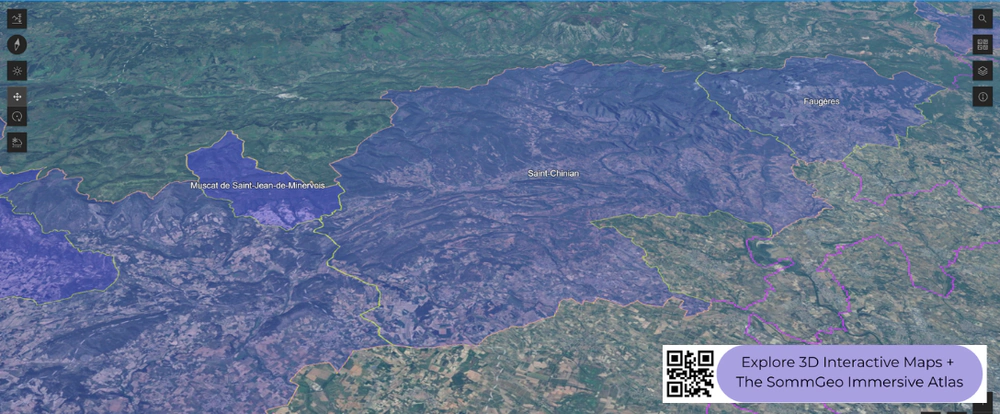
The appellations that have driven the Languedoc’s quality reputation are the ones in the hills, away from the hot, flat coastal plains. Terrasses du Larzac sits on the southern edge of the Larzac plateau at elevations between 100 and 400 meters (328 and 1,312 ft), where altitude brings cooler nights and the garrigue-covered limestone delivers wines with freshness and aromatic complexity that the lowlands cannot match. Pic Saint-Loup, named for the distinctive limestone peak north of Montpellier, benefits from a similar altitude effect and cool air drainage from the Cévennes. Saint-Chinian, visible in the screenshot, divides geographically: the northern half sits on schist (producing firmer, more structured wines) while the southern half rests on clay-limestone (rounder, more approachable). Faugères, next door, is entirely on schist. Minervois occupies a south-facing amphitheater between the Canal du Midi and the Montagne Noire. Corbières, the largest appellation by area, covers varied terrain from coastal flats to inland hills. The common thread is Grenache, Syrah, Mourvèdre, and Carignan in varying proportions.
Roussillon
South of the Languedoc, Roussillon occupies the broad amphitheater formed by the eastern Pyrenees as they meet the Mediterranean. The Agly, Têt, and Tech rivers cut through the landscape, creating sheltered valleys with distinct mesoclimates. The region is historically known for its Vins Doux Naturels: Banyuls and its Grand Cru (Grenache-based, fortified, on steep schist terraces above the sea), Maury (Grenache Noir in a hot inland valley on schist and limestone), and Rivesaltes (multiple styles from a larger zone). The dry reds of Côtes du Roussillon and Côtes du Roussillon-Villages have gained attention more recently, driven by old-vine Grenache and Carignan on the rocky, low-yielding soils of the inland valleys. The Pyrenean foothills visible in the 3D map provide the backdrop and the altitude that distinguish the better sites from the coastal plain.
New to 3D Fast Maps? Learn how to navigate 3D terrain, use elevation profiles, animate sunlight, and get the most from your map.
3D Fast Maps Guide →Ready to explore the Languedoc and Roussillon in full 3D? Join 200+ wine organizations already using SommGeo.
Start Your 15-Day Free Trial $5/month billed annually after trial · Cancel anytimeMap Usage & Permissions
Personal Use
You are welcome to use, download, and share the maps on this site for personal, educational, and non-commercial purposes. If you share a map, please credit SommGeo with a link back to sommgeo.com.
Commercial Use
Use of these maps for any commercial purpose, including websites, print publications, marketing materials, or any other commercial venture, is strictly prohibited without prior written permission.
To inquire about custom SommGeo platforms, maps, or commercial licensing, please contact greg@sommgeo.com.