Free Wine Maps
Reference-grade cartography, free to download.
A curated library of high-resolution wine maps built for study, presentation, and professional reference. Each map is freely available for download, with the clarity and detail that serious wine education demands.
Print-Ready Wine Maps, Free to Download
Each map is rendered at a resolution suitable for study sheets, classroom projection, trade presentations, or large-format print. Drawn from verified appellation boundaries and terrain data, at the clarity serious wine education demands.
High-Resolution Files
Every map is rendered large enough to hold detail at full-screen projection or printed poster scale. No pixelation when you zoom in on a sub-appellation or blow it up for a training session.
Verified Appellation Boundaries
Boundaries are drawn from official cadastral and appellation sources, not approximations. What you see is where the lines actually fall.
Built for Professional Use
Designed for sommeliers, educators, and trade professionals who need clean, accurate reference material. Print them, project them, drop them into study decks, or use them as the anchor for a regional training.
Select a Region
Each map opens its own page with a larger preview and a direct download link. The collection spans Old World appellations with layered hierarchies and New World regions where terrain does the defining.
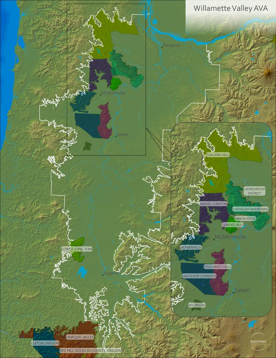
Willamette Valley
The full AVA hierarchy from the Eola-Amity Hills to the Dundee Hills, rendered against the valley’s signature basalt and marine sediment terrain.
View Map
Oregon
Every Oregon AVA at a glance, from the Willamette Valley in the north to the Rogue and Umpqua Valleys to the south, with the shared cross-border appellations clearly shown.
View Map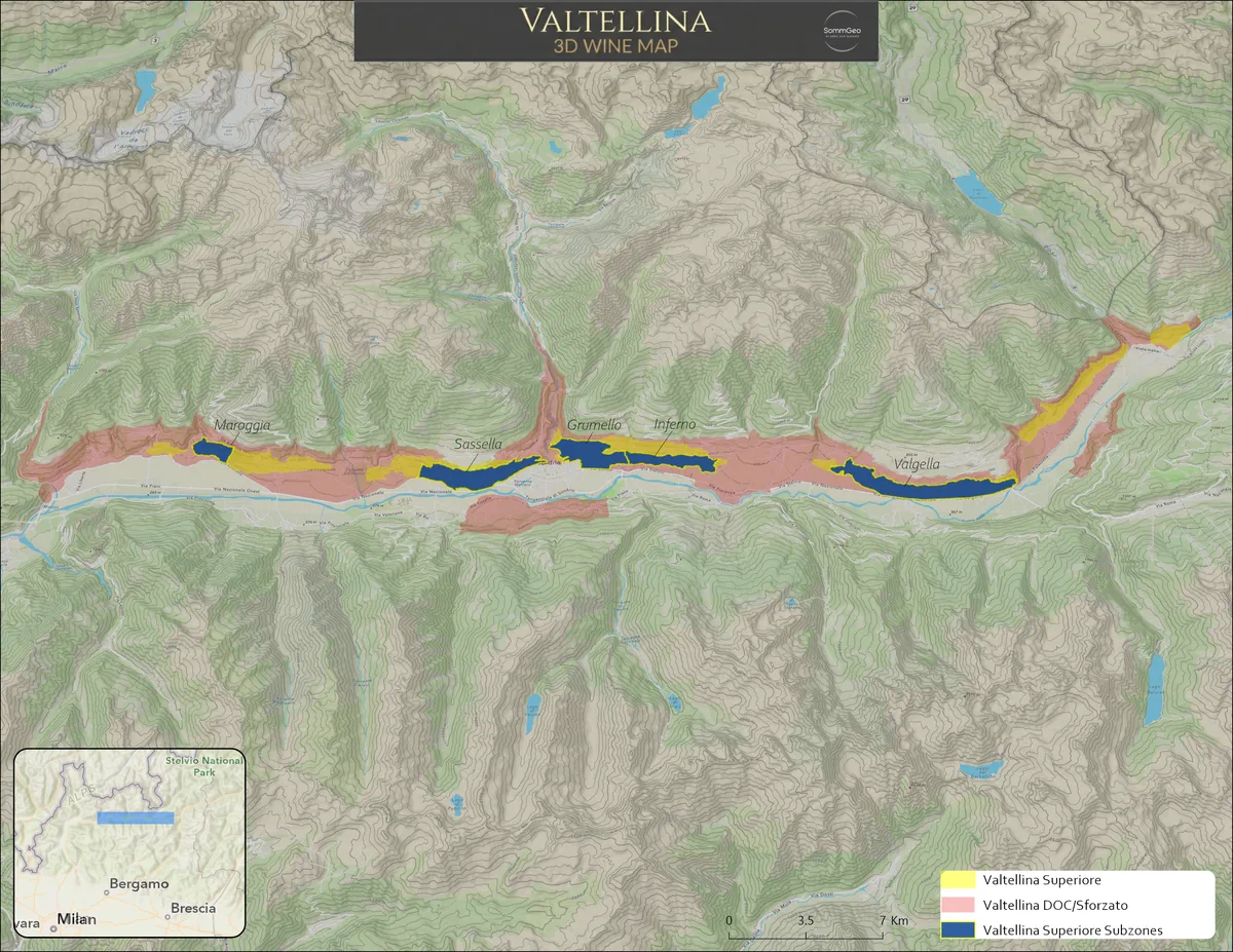
Valtellina
The Alpine terraces of Lombardy’s Chiavennasca country, with the five Valtellina Superiore sub-zones laid out across the south-facing slopes above the Adda River.
View Map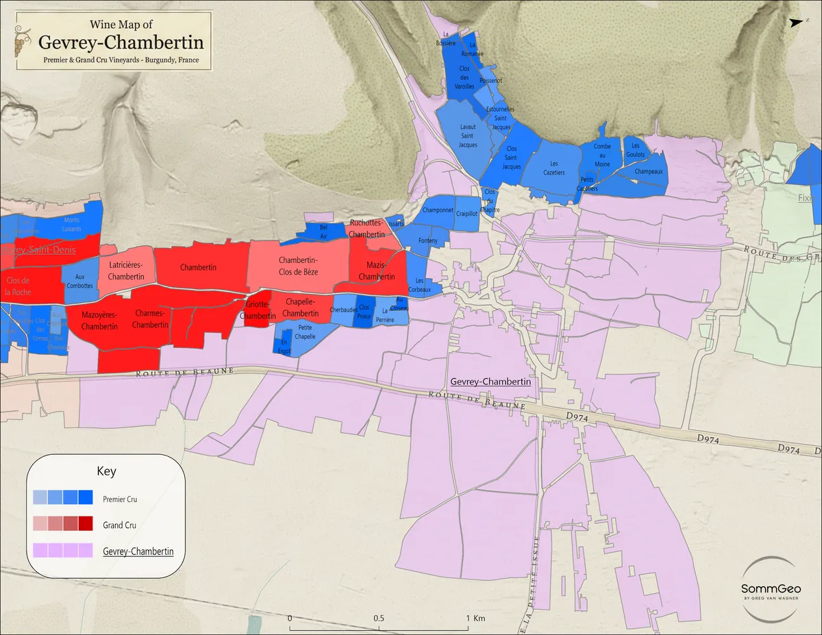
Gevrey-Chambertin
Vineyard-level cartography of Gevrey-Chambertin, with all nine Grands Crus and the premier cru climats rendered to the parcel.
View Map
Galicia
The five DOs of green Spain, from the Atlantic-soaked sub-zones of Rías Baixas through the schist slopes of Ribeira Sacra and Valdeorras inland.
View Map
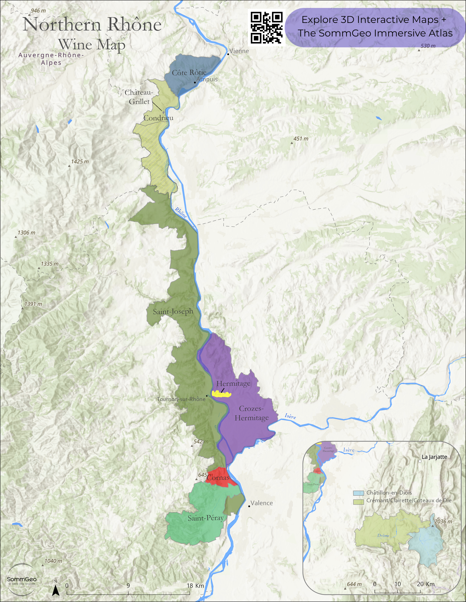
Northern Rhône
All eight appellations of the Northern Rhône, from Côte-Rôtie down through Hermitage, Cornas, and Saint-Péray, with the granite-and-schist terrain that defines them.
View Map
Beaujolais
All ten crus from Saint-Amour to Côte de Brouilly, mapped across the granite and blue stone hills that give the region its range.
View Map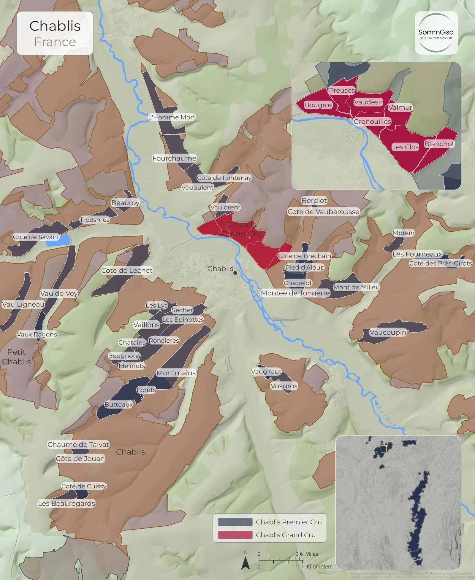
Chablis
The seven Grand Crus and every Premier Cru climat, split across the two banks of the Serein on Chablis’s signature Kimmeridgian limestone.
View Map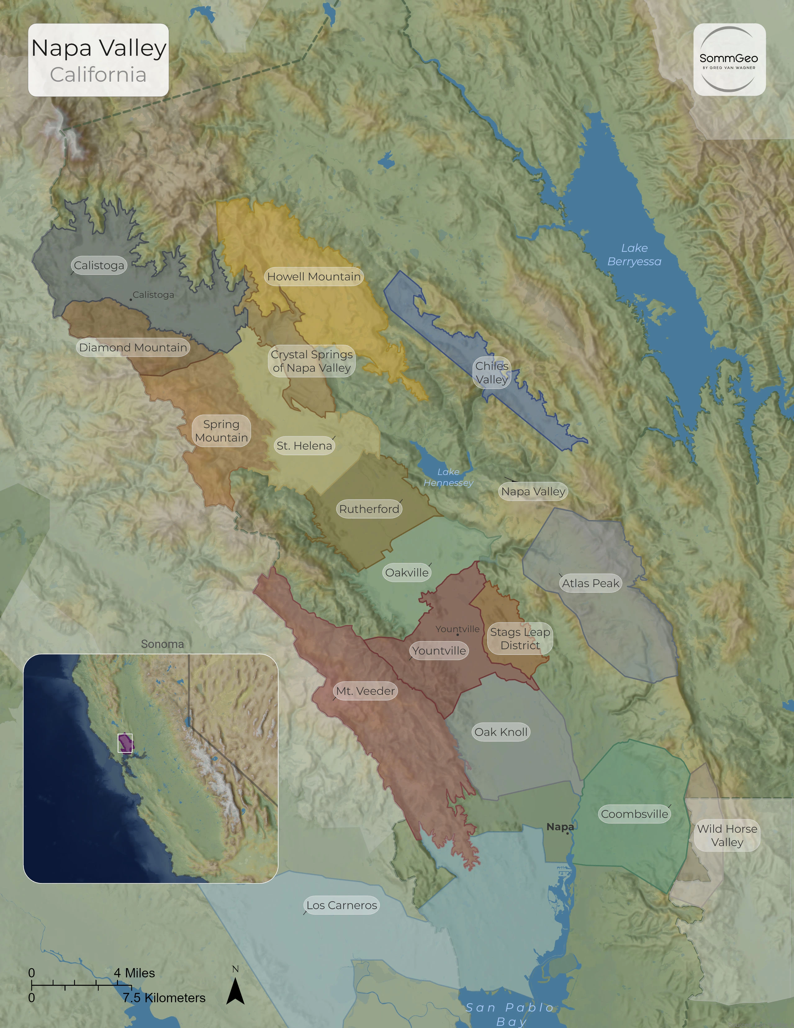
Napa Valley
All seventeen nested AVAs, from the valley-floor benchland of Oakville and Rutherford to the mountain appellations of the Mayacamas and Vaca ranges.
View MapCustom Cartography for Producers, Regions, and the Trade
SommGeo builds commissioned wine maps for trade associations, importers, wineries, and regional promotional bodies. Wall-scale cartography, branded reference maps for sales teams, and custom interactive digital atlases.
Beyond the Printed Page
These static maps are the surface. The SommGeo platform adds interactivity, 3D terrain, and reference-grade content for every mapped region.
The Globe
Every wine region on Earth, one searchable 3D globe.
LaunchFast Maps
A searchable interactive atlas of every appellation in every country.
Browse AtlasMap Makers
Build your own custom maps with toggleable layers and 3D terrain.
Build a MapTours
Immersive 3D flyovers with reference-grade regional detail.
Take a TourTools
Pricing, pour cost, profitability, and conversion calculators.
Open Tools