Argentina Wine Map Maker: Build Custom Maps
Measure elevations across Uco Valley, simulate sunlight on Cafayate’s slopes, annotate Mendoza’s sub-regions. This isn’t a map you look at, it’s one you build.
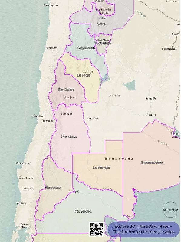
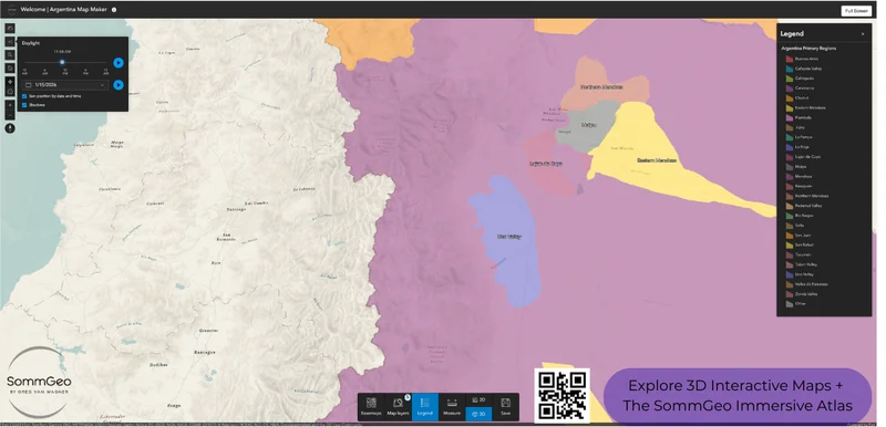
The Argentina Map Maker puts a professional GIS toolkit in your hands. Every major Argentine wine region (from the high-altitude Malbec heartland of Mendoza to the remote vineyards of Patagonia and the vertiginous Torrontés country of Salta) is here with full boundary data, satellite imagery, and analysis tools that go far beyond a standard wine map. Switch between 2D and 3D to understand why altitude is the defining variable in Argentine viticulture. Run an elevation profile across Uco Valley and watch the terrain drop 500 meters (1,640 ft) in 18 kilometers (11 miles). Simulate daylight to see how the Andes cast shadows over western-facing vineyards at different times of year. Or use the Sketch tools to annotate, label, and save a custom view for a presentation, class, or buying trip. And every mapped region includes detailed popup content covering grape varieties, elevation data, climate profiles, soil types, a sommelier-level reference built directly into the map.
Unlock the Full SommGeo Toolkit
Gain exclusive access to our entire suite of premium features, including interactive Map Makers, immersive 3D Tours, high-resolution classic Maps, and advanced analytical tools.
Start Free TrialWhat You Can Build
Unlike a static wine map, the Argentina Map Maker is a full interactive workspace, and the real depth is in what each region reveals. Click on any mapped area and a comprehensive info panel opens with sommelier-level content: grape variety breakdowns, elevation ranges, climate profiles, soil composition, sub-region details. Whether you’re reading about Uco Valley’s 28,500 hectares (70,425 acres) at 900–1,500 meters (2,953–4,921 ft) or Cafayate’s extreme diurnal shifts at 1,700 meters (5,577 ft), every mapped region carries this level of built-in intelligence. Beyond the content, every tool in the bottom toolbar opens a different way to interrogate Argentine wine geography, and you can save your custom views to revisit or share.
- In-depth region profiles: Click any mapped area for detailed content covering varieties, elevation, climate, soils
- 3D / 2D Toggle: Switch between flat overview and immersive 3D terrain to see how the Andes shape every vineyard site
- Daylight Simulator: Set any date and time to model sun position and shadow cast across vineyard sites
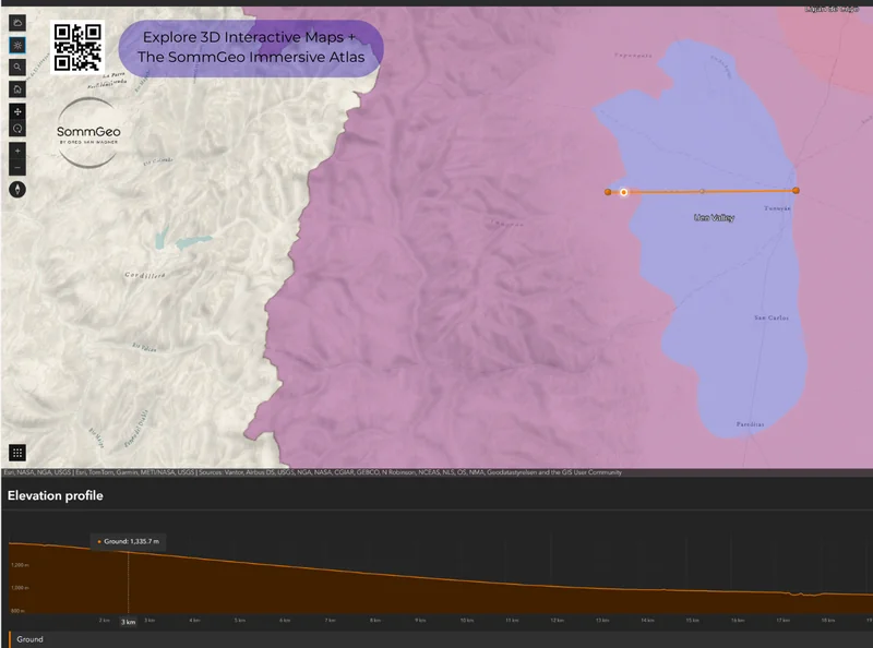
- Measure Tool: Draw lines to measure distances and generate elevation profiles between any two points on the map
- Sketch & Annotate: Drop pins, draw shapes, and add text labels to build custom presentations directly on the map (2D only)
- Legend & Map Layers: Toggle region boundaries on and off, adjust layer transparency, and use Interactive Legend to load zones one at a time
Tools in Action
Each tool in the Map Maker pairs with a specific geographic story that’s hard to tell any other way. Here’s how wine professionals are using them.
🏔️ Elevation Profile + Uco Valley
Draw a line from the Andes foothills across Uco Valley and the Measure tool generates an elevation cross-section. You’ll see exactly why Gualtallary (around 1,500m (4,921 ft)) produces radically different Malbec than Paraje Altamira (around 1,150m (3,773 ft)), the altitude drop changes everything from UV exposure to diurnal temperature swings to soil composition.
☀️ Daylight Simulator + Cafayate
Set the Daylight tool to a winter date in Cafayate and watch how the surrounding mountains cast shadows across the valley floor. In a region where sunlight intensity is already extreme and diurnal temperature variation can exceed 25°C (77°F), understanding when and where shade falls is critical to understanding site character.
🌐 3D Mode + San Juan
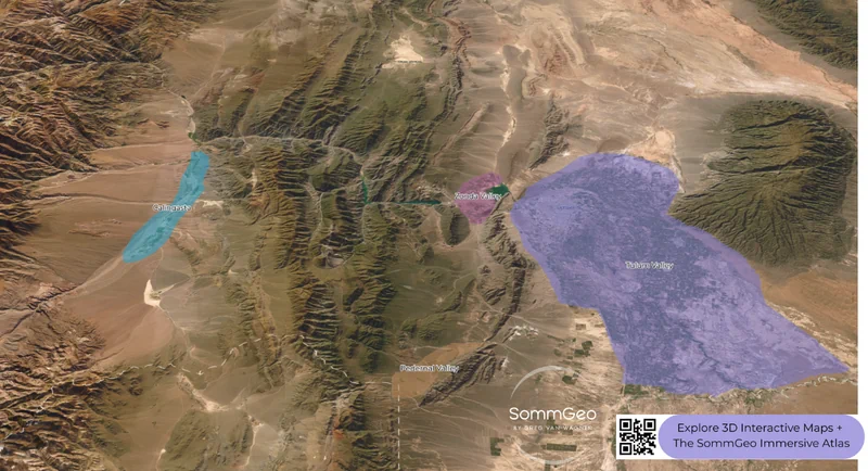
The Precordillera ranges separating Calingasta, Zonda Valley, and Tulum Valley are nearly impossible to appreciate in 2D. Switch to 3D satellite view and the parallel mountain ridges become obvious, each creating a distinct rain shadow and microclimate pocket. This is how you understand why Pedernal Valley is producing genuinely interesting wine despite San Juan’s bulk-wine reputation.
✏️ Sketch + Presentation Building
Prepping a staff training on Argentine wine? Drop labeled pins on each major zone, draw boundary highlights, add text annotations explaining key differences, and save the custom view. It’s a finished visual aid without opening PowerPoint. Use Save to export your annotated map as a downloadable image (uncheck “Include Legend” for a cleaner result).
Argentina’s Wine Geography
Argentina is the world’s fifth-largest wine producer, and its viticultural identity is defined by one overwhelming geographic fact: the Andes. Nearly every significant wine region sits in the rain shadow of the longest continental mountain range on earth, creating an environment of extreme aridity; some zones receive less than 200mm (7.9 in) of annual rainfall, intense solar radiation, and the kind of dramatic altitude variation that makes a GIS tool genuinely useful for understanding these wines.
Mendoza alone accounts for roughly 70% of Argentina’s wine production, with vineyards planted between 600 and 1,600 meters (1,969–5,249 ft) above sea level. That elevation range would be unthinkable in most European wine countries. It’s also why Malbec from Uco Valley’s Gualtallary district tastes categorically different from Malbec grown on Eastern Mendoza’s flatlands: cooler temperatures, higher UV exposure, greater diurnal temperature swings, and dramatically different soils (alluvial and calcareous at altitude versus sandy loam on the plain). The Map Maker’s elevation profile and 3D tools let you visualize these differences in a way that no flat map ever could.
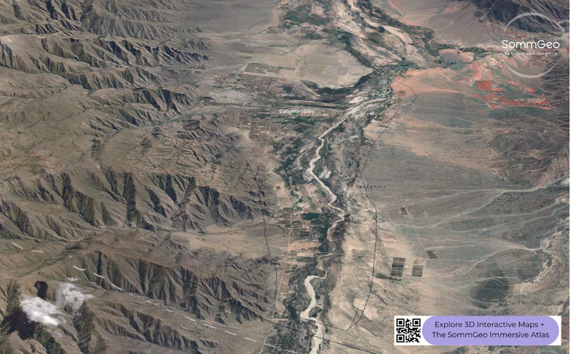
Beyond Mendoza, Salta’s Cafayate Valley pushes altitude to its limits; vineyards above 1,700 meters (5,577 ft), some approaching 3,000 meters (9,843 ft) at Bodega Colomé, one of the highest commercial wineries in the world. San Juan, historically a bulk-wine province, is finding serious quality potential in elevated sub-regions like Pedernal Valley and Calingasta. And in Patagonia, Neuquén and Río Negro represent Argentina’s cool-climate frontier near the 40th parallel, where Atlantic-influenced winds produce a completely different style: leaner Pinot Noir and Malbec with a freshness you won’t find in Mendoza.
Key Regions to Build
Mendoza: Uco Valley, Luján de Cuyo & Maipú
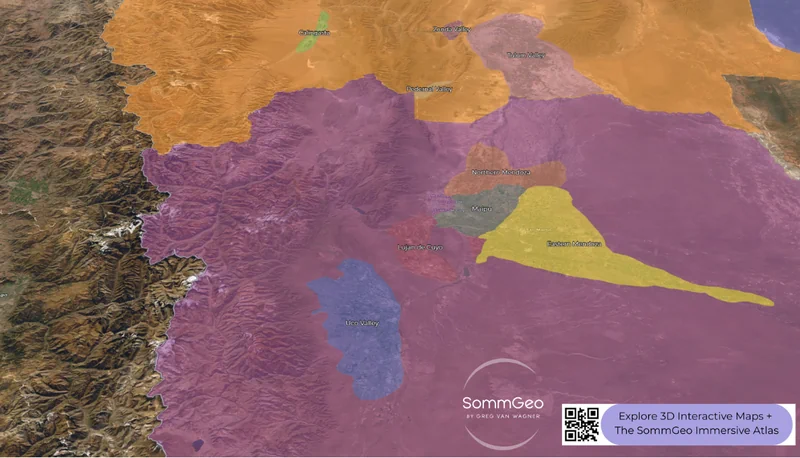
The Map Maker earns its keep in Mendoza, where sub-regional differences are enormous but invisible on a standard map. Use the 3D satellite view to see how Uco Valley pushes up against the Andes while Luján de Cuyo occupies the middle benchland and Eastern Mendoza stretches flat toward the plains. Uco Valley has become the prestige address; Catena Zapata, Zuccardi, Salentein, and a growing roster of boutique producers are making some of South America’s most compelling wines from Tupungato, Tunuyán, and San Carlos. Within the valley, the unofficial districts tell their own stories: Gualtallary’s calcareous soils at 1,500+ meters (4,921+ ft) yield Malbec with tension and minerality, Vista Flores’ sandy soils in Tunuyán produce aromatic and elegant styles, and Paraje Altamira’s alluvial clay at a relatively lower 1,150 meters (3,773 ft) delivers lush, structured wines. Run the elevation profile tool from the Andes east and watch the altitude, UV intensity, and character all shift together.
Luján de Cuyo, just south of Mendoza city, is the historic heart of Argentine Malbec; it earned the country’s first appellation designation (DOC) in 1993. The sub-districts of Agrelo, Vistalba, Las Compuertas, and Perdriel each have their partisans, and the Map Maker lets you compare their positions, elevations, and proximity to the Andes at a glance. Maipú, the adjacent zone, includes the slightly warmer Barrancas district and a concentration of large, historic bodegas including Trapiche and López.
Salta: Cafayate & the Calchaquí Valleys
Salta is where Argentine altitude viticulture reaches its most extreme expression, and where the 3D view becomes essential. Cafayate Valley (home to Argentina’s finest Torrontés and increasingly serious Malbec and Cabernet) sits in a narrow valley above 1,700 meters (5,577 ft), surrounded by mountains that create one of the driest, sunniest vineyard environments in the world. Annual rainfall barely reaches 150mm (5.9 in), and summer daytime temperatures can hit 38°C (100°F) before plummeting to 12°C (54°F) at night. That thermal amplitude (possibly the most dramatic diurnal swing in any major wine region) is what gives Cafayate wines their aromatic intensity and natural acidity.
Beyond Cafayate, the Calchaquí Valleys extend over 270 kilometers (168 miles) through three provinces (Salta, Tucumán, and Catamarca) with vineyards pushing progressively higher. North of Cafayate, the sub-regions of Molinos and Cachi scale above 2,700 meters (8,858 ft), and in Jujuy’s Quebrada de Humahuaca, a few adventurous producers are planting above 3,000 meters (9,843 ft). Toggle the Daylight simulator in this terrain and you’ll see why morning versus afternoon sun exposure matters so much at these altitudes.
San Juan: Pedernal, Calingasta & Tulum
San Juan is Argentina’s second-largest wine province by volume, though historically most of that production was forgettable table wine from the hot Tulum Valley floor. The Map Maker reveals why that reputation is changing: switch to 3D and zoom into the Precordillera zone to see the isolated high-altitude valleys (Pedernal, Calingasta, Zonda) that are producing genuinely compelling Syrah, Malbec, and Cabernet Franc. Pedernal Valley in particular has gained international acclaim for wines with an altitude-driven intensity that can recall Uco Valley, despite being far less well-known. The parallel mountain ridges visible in the 3D view create discrete climate pockets that are radically different from the bulk-production flatlands to the east.
Patagonia: Neuquén & Río Negro
Argentina’s southern frontier. The Map Maker’s 2D overview shows how far south these vineyards actually sit, roughly the same latitude as New Zealand’s Central Otago. Neuquén and Río Negro get Atlantic-influenced winds and longer daylight hours during the growing season that Mendoza never sees, producing Pinot Noir and Malbec with a leaner, more restrained profile. Vineyards here sit at a much lower average altitude (250–300m (820–984 ft)) than the northern regions, so the cool-climate character comes from latitude and wind rather than elevation. Bodega Chacra, founded by Piero Incisa della Rocchetta of Sassicaia fame, has put Patagonia on the serious wine map, and the emerging coastal plantings in Río Negro near the Atlantic are pushing the frontier even further.
New to the Map Makers? Explore all the tools, tips, and features in our complete walkthrough.
Map Maker Guide →Ready to build your own Argentine wine maps? Join 200+ wine organizations already using SommGeo.
Start Your 15-Day Free Trial $5/month billed annually after trial · Cancel anytimePlease let us know what you think in the form below. Thanks!

