Spain Wine Map Maker: Build Your Own Interactive Map
Over 70 Denominaciones de Origen, the scattered geography of Cava, and everything from the Meseta Central to the Canary Islands. Spain’s wine complexity demands a tool that lets you take the wheel.
Spain has the most vineyard acreage of any country on earth. Let that sink in for a moment: more than France, more than Italy, more planted surface area than anyone. And yet it remains one of the most underexplored wine countries, partly because the sheer scale and complexity of its DO system can be overwhelming. The Spain Map Maker changes that. This is a fully interactive workspace where you can switch between satellite imagery, topographic relief, mid-century cartography, and the SommGeo Blank Earth basemap to study every Spanish DO, DOCa, and Vino de Pago on your own terms. Measure the 120-kilometer stretch of the Duero River that defines Ribera del Duero. See why Cava production is scattered across seven autonomous communities. Fly over the albariza hills of Jerez in 3D. Whether you’re building exam study guides, prepping sales presentations, or simply trying to understand how a single country produces everything from Albariño to Amontillado, this is the tool for it. Every mapped region includes detailed popup content covering grape varieties, classification rules, climate profiles, soil types, a sommelier-level reference built directly into the map.
What You’ll Explore
The Spain Map Maker is an active workspace, not a passive reference, and the real depth is in what each region reveals. Click on any mapped DO and a comprehensive info panel opens with sommelier-level content: permitted grape varieties, classification rules, climate and geographic profiles, soil composition, the viticultural specifics that define each appellation. Whether you’re reading about Rioja’s limestone and clay across its three sub-zones, the llicorella slate driving Priorat’s concentrated reds, or the albariza chalk of Jerez’s finest vineyards, every mapped region carries this level of built-in intelligence. Beyond the content, you choose the basemap, toggle DO layers, measure distances, drop placemarks, and shift between 2D overhead views and immersive 3D terrain exploration.
- All DO, DOCa, and Vino de Pago boundaries across Spain’s 17 autonomous communities
- In-depth appellation profiles for every mapped area: varieties, classification, soils, climate
- 40 basemaps: satellite imagery, topographic relief, mid-century cartography, SommGeo Blank Earth, and more
- Measurement tools for calculating distances and areas between DOs, towns, and landmarks
- Placemark and annotation tools for building custom study maps and presentation materials
- Cava DO boundaries across all producing regions. Visualize why this is Spain’s most geographically scattered appellation
Geography That Shapes Spanish Wine
Spain’s viticultural identity is built on extremes. The Meseta Central (a vast interior plateau averaging 600–700 meters (1,969–2,297 ft) in elevation) dominates the country’s center, creating a continental climate of baking summers and frigid winters that’s utterly different from the maritime conditions on the coasts. Switch to 3D view in the Map Maker and the topography tells the story immediately: mountain ranges like the Cantabrian Cordillera in the north, the Sierra de Guadarrama dividing the Mesetas, and the Pyrenees along the French border all create rain shadows and climatic corridors that dictate where vines can thrive and what styles of wine they produce.
This geographic complexity is what makes Spain so rewarding to study with an interactive tool. The green, rain-soaked northwest (Galicia and the Basque Country) has more in common climatically with Vinho Verde across the Portuguese border than with La Mancha, which sits barely 300 kilometers (186 miles) to the southeast on the sun-scorched central plateau. The Mediterranean coast from Catalonia down through Valencia and Murcia operates under an entirely different set of conditions again, while Andalucía in the far south brings quasi-African heat that would seem hostile to viticulture if not for the cooling Atlantic breezes and the remarkable moisture-retaining properties of albariza soils in the Sherry zone. And then there are the Canary Islands, volcanic outposts in the Atlantic where vines are grown in hollowed-out pits to shield them from relentless trade winds, producing wines from varieties that exist nowhere else on earth.
Key Regions to Explore in the Map Maker
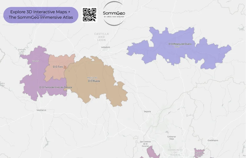
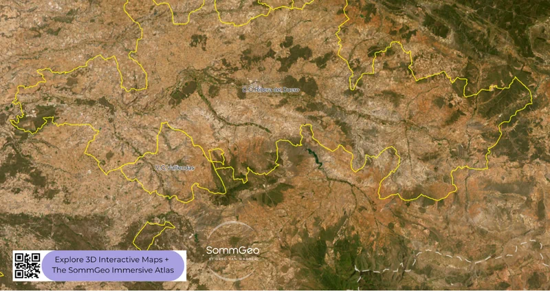
Castilla y León & the Duero River Corridor
Zoom into Castilla y León on the simplified basemap and you’ll see something striking: Spain’s most prestigious interior DOs are all connected by a single river. The Duero (which becomes the Douro once it crosses into Portugal) threads through Ribera del Duero, Toro, Rueda, and flows past Cigales, four appellations with four distinct identities, linked by water and geography. Ribera del Duero is the headliner, a roughly 115-kilometer stretch of high-altitude vineyard land (700–1,000 meters (2,297–3,281 ft)) where Tempranillo (called Tinto Fino or Tinta del País locally) produces structured, concentrated reds with massive diurnal temperature swings that preserve acidity. Producers like Vega Sicilia (Spain’s most legendary estate, producing wine since 1864), Pingus, Pesquera, and Aalto have established this as one of Europe’s premier red wine regions. To the west, Toro’s ancient Tinta de Toro vines (many pre-phylloxera, ungrafted) produce wines of raw power. And Rueda, just south of the river, is Verdejo country, one of Spain’s most important indigenous white varieties, producing wines of structure and aromatic complexity that punch far above their price point.
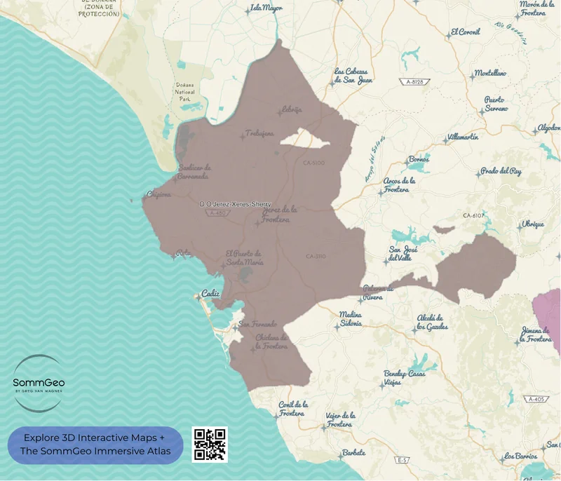
Jerez & the Sherry Triangle
Switch to the mid-century cartographic basemap and pan south to Andalucía. The Marco de Jerez reveals itself beautifully in this view. The Sherry Triangle (Jerez de la Frontera, Sanlúcar de Barrameda, and El Puerto de Santa María) is Spain’s oldest denominated wine region, with Jerez formally recognized in 1933 as the country’s first DO. But the tradition predates that by millennia; Phoenician traders were making wine here more than 3,000 years ago. The albariza soils are the key: chalk-white, fossil-rich limestone containing up to 80% calcium carbonate that absorbs winter rainfall like a sponge and retains it through brutally hot summers. Use the 3D view to see the gentle rolling hills where these soils dominate, then toggle to satellite to see how close the vineyards sit to the Atlantic coast; that proximity to the sea is what makes flor (the biological film of yeast that defines Fino and Manzanilla) possible in a region this warm. The recent expansion of the aging zone from the original three towns to ten municipalities is reshaping the geography of Sherry production.
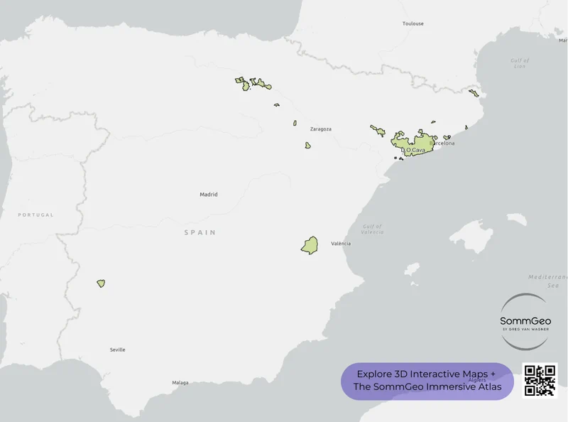
Cava’s Scattered Geography
Here’s where the Map Maker becomes genuinely indispensable for understanding Spanish wine law. Toggle the Cava DO layer on the Blank Earth basemap and you’ll see something unlike any other European appellation: production zones scattered across Catalonia, Aragón, La Rioja, Navarra, País Vasco, Valencia, and Extremadura. About 95% of Cava comes from the Penedès area near Barcelona, specifically the town of Sant Sadurní d’Anoia, where Codorníu and Freixenet built the industry, but the DO legally extends across seven autonomous communities. This non-contiguous geography is one of the most politically fraught aspects of Spanish wine regulation, and it’s a major reason why breakaway movements like Corpinnat (founded by nine estates seeking a more terroir-specific designation tied exclusively to Penedès) have gained traction. Seeing the full extent of the Cava DO on a single map makes the complexity of this debate immediately obvious.
Rioja & the Ebro Valley
Rioja holds DOCa status, Spain’s highest classification, shared only with Priorat (DOQ in Catalan), and for good reason. Toggle the Rioja boundaries in the Map Maker and you’ll see three distinct sub-zones shaped by geography: Rioja Alta to the west (higher elevation, Atlantic influence, more elegant wines), Rioja Alavesa across the Ebro in Basque Country (chalky clay soils, smaller plots, structured reds), and Rioja Oriental to the east (warmer, drier, Mediterranean influence, fuller-bodied wines). The 3D view reveals how the Sierra de Cantabria to the north shields the valley from Atlantic weather while the Sierra de la Demanda to the south creates a protective bowl. Nowadays, the conversation has shifted from the traditional Crianza-Reserva-Gran Reserva aging classifications toward single-vineyard and village-level designations, a recognition that place matters as much as time in barrel.
The Northwest: Galicia & the Atlantic Whites
Pan to Spain’s northwest corner and the landscape changes dramatically; the green, rain-soaked coast of Galicia looks nothing like the rest of Spain. Rías Baixas is the flagship DO here, where Albariño thrives on granitic soils along the dramatic ría inlets of the Atlantic coast. Switch to satellite view and the coastal influence is unmistakable. But don’t overlook the interior DOs: Ribeira Sacra, where Mencía vines cling to impossibly steep terraced slopes above the Sil and Miño rivers (some of the most dramatic vineyard sites in all of Europe), and Valdeorras, where the indigenous Godello grape is producing some of Spain’s most exciting mineral whites. The 3D terrain view of the Sil canyon in Ribeira Sacra is genuinely jaw-dropping; it makes the case for why these wines exist better than any tasting note ever could.
New to the Map Makers? Explore all the tools, tips, and features in our complete walkthrough.
Map Maker Guide →Ready to build your own Spain wine maps? Join 200+ wine organizations already using SommGeo.
Start Your 15-Day Free Trial $5/month billed annually after trial · Cancel anytimePlease let us know what you think in the form below. Thanks!

