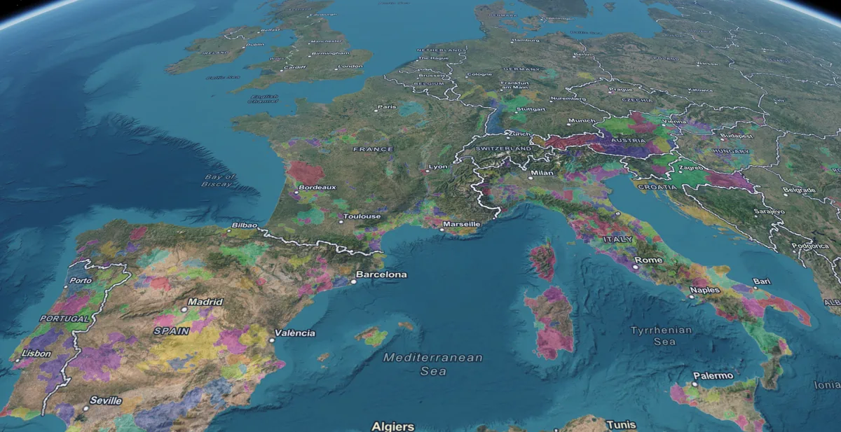
The SommGeo Globe
Every major wine region. One searchable 3D globe.
Search any appellation, fly to its terrain, read its story. Over 1,600 distinct wine regions on an interactive 3D globe with the curvature and topography flat maps cannot show. Google Earth for the wine world.
Seeing the Wine World as It Actually Exists
Traditional flat maps distort size and distance, often misrepresenting the proximity of key wine regions. The Globe renders real topography on a true sphere, with over 1,600 searchable appellations. Search any region, fly to its terrain, and read its story without switching tools.
True Global Perspective
Wine bands, ocean proximity, and continental relationships are visible at a glance. No distortion, no guesswork about where regions sit relative to each other.
Search and Fly
Type any appellation name and the Globe moves you there. Over 1,600 regions, all searchable, with popup information for each one.
Sun Aspect and Elevation
Animate the sun’s path across any date. Draw elevation profiles across any vineyard. The tools that make geography tangible are built in.
Visualizing the World of Wine in Three Dimensions
Wine is not a two-dimensional subject, and it shouldn’t be studied on a two-dimensional map. Traditional flat maps distort size and distance, often misrepresenting the proximity of key wine regions to each other. The SommGeo Globe renders the wine world as it truly exists: on a sphere, with real curvature, real topography, and over 1,600 distinct appellations searchable by name. Nothing like it exists anywhere else.
Latitude and Climate Bands
Visualize the famous wine bands between 30 and 50 degrees latitude in both hemispheres. See exactly where each region falls relative to the equator, and understand why that position dictates everything from growing season to grape selection.
Proximity to Water
Observe how the world’s greatest wine regions hug the coastlines of the Pacific, Atlantic, and Indian Oceans, or cluster around major moderators like the Mediterranean Sea, the Danube, and the Rio Negro.
Topography at Scale
From the rain shadow of the Andes to the contiguous flow of the European continent, see how mountain ranges define the borders of flavor. The Globe’s real elevation data reveals the terrain beneath every appellation.
Unlock the Full SommGeo Toolkit
Gain exclusive access to our entire suite of premium features, including interactive Map Makers, immersive 3D Tours, high-resolution classic Maps, and advanced analytical tools.
Start Free TrialMastering the Globe Tools
The Globe is fully interactive. Search, tilt, draw elevation profiles, and switch basemaps to study wine regions in a way that no other tool allows. Here is what each control does.
Global Search
Top Right: Click the magnifying glass. Type any region (for example, “Barolo”) to fly there instantly.
Change Basemap
Top Right: Click the four-squares icon. Choose from satellite, terrain, topographic, and other base layer styles.
Navigation
Compass: Revert view to due North. Right Click + Drag: Tilt the view into 3D. Enable map scroll: Allow zooming with your mouse wheel.
Navigate Overlapping Regions
Popup Arrows: Many wine regions overlap. Click a location and use the arrows in the popup header (for example, “1 of 3”) to scroll through specific appellations at that point.
Daylight and Shadows
Left Sidebar: Animate the sun’s path for any date to visualize slope exposure and aspect. Essential for understanding how orientation shapes grape ripening across different hemispheres.
Elevation Profile
Left Sidebar: Click the graph icon, then draw a line on the map to see altitude and slope gradients. Useful for visualizing the elevation changes across a vineyard or between neighboring appellations.


A Custom Globe for Your Organization
Regional promotion boards, trade organizations, and large importers commission custom Globe overlays to showcase their specific appellations and territories. Your regions highlighted, your data layered in, delivered as an interactive experience your trade audience can explore independently.
See the Wine World as It Actually Exists.
Over 1,600 appellations on one interactive 3D globe. Search any region, fly to its terrain, and read its story. Nothing like this exists anywhere else in wine education.
The Rest of the Platform
The Globe is one view. Here is what else is inside.
Fast Maps
Searchable atlas of every appellation in every country.
Browse AtlasMap Makers
Build your own maps with layers, regions, and terrain.
Build a MapTours
Guided 3D presentations through the world’s wine regions.
Browse ToursTools
Pour cost, pricing, and conversion calculators.
Open ToolsClassic Maps
High-resolution cartographic wine maps for print.
View Maps