Columbia Valley 3D Wine Map
Walla Walla, Red Mountain, Yakima Valley, Horse Heaven Hills, and the Columbia Valley AVAs in full 3D terrain.
The Columbia Valley is the engine of Washington State wine, covering roughly 11 million acres in the rain shadow of the Cascade Range. East of the mountains, the landscape becomes a vast, arid basin shaped by ancient basalt floods and catastrophic Ice Age floods that deposited the loess and alluvial gravels where vines now grow. Rainfall is minimal (often under 8 inches / 200 mm per year), so nearly all viticulture depends on irrigation from the Columbia and Yakima rivers. What the terrain provides is intense sunshine, long summer days at the 46th parallel, and dramatic diurnal swings that preserve acidity while building concentration. This map covers the Columbia Valley AVAs with detailed popup data. Use the layer controls to filter by outlines or shading and the elevation profile tool to trace the ridges and valleys that distinguish each sub-appellation.
Unlock the Full SommGeo Toolkit
Gain exclusive access to our entire suite of premium features, including interactive Map Makers, immersive 3D Tours, high-resolution classic Maps, and advanced analytical tools.
Start Free TrialWhat You’ll Explore
This 3D Fast Map covers the AVAs of Washington’s Columbia Valley and its nested sub-appellations. Click any mapped AVA for detailed popup content covering grape varieties, classification details, and geographic specifics. Use the layer controls to toggle different AVA groupings on and off and the elevation profile tool to trace the ridges, river valleys, and bench elevations that define site character across the region.
- Columbia Valley AVAs and nested sub-appellations mapped with detailed popup data
- Elevation profile tool for measuring ridge lines, bench elevations, and river valleys
- Daylight and shadow animation to visualize aspect and the long summer photoperiod
- Detailed popup data for every mapped AVA
Key Regions in Focus
Red Mountain, the Tri-Cities Cluster, and Rattlesnake Hills
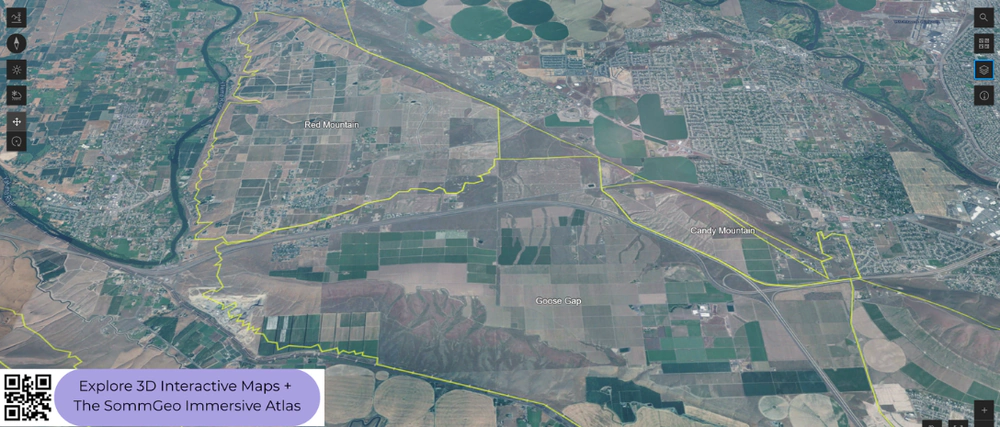
Red Mountain is one of the smallest and most celebrated AVAs in Washington, and in 3D the reason is obvious: a compact, southwest-facing slope at 700 to 1,400 feet (215 to 425 m) above the Yakima River that catches intense afternoon sun and heat. The well-drained, alkaline soils produce Cabernet Sauvignon with power, tannin, and concentration that few other Washington sites can match. Goose Gap and Candy Mountain, neighboring AVAs visible in the screenshot, occupy slightly different aspects and elevations with distinct soil profiles. Rattlesnake Hills, further west in the Yakima Valley, sits on a south-facing ridge at higher elevation with soils derived from ancient Cascade volcanic sediment rather than the basalt that dominates the broader Columbia Valley floor, producing wines with more aromatic lift. The elevation profile tool is especially useful for tracing the ridge that gives Red Mountain its advantage.
Walla Walla Valley
Walla Walla is the most recognized name in Washington wine and straddles the Washington-Oregon border. The valley floor sits at roughly 800 to 1,000 feet (245 to 305 m) on deep loess deposits, while the surrounding foothills rise to 2,000 feet (610 m) toward the Blue Mountains. The Rocks District of Milton-Freewater, an Oregon AVA within the Walla Walla appellation, sits on a gently sloping alluvial fan, defined by basalt cobblestones deposited by the Walla Walla River. Syrah dominates The Rocks District, producing wines with distinctive savory, mineral character. Across the broader valley, Cabernet Sauvignon is the most planted variety at roughly 37% of acreage, followed closely by Syrah and Merlot, each near 17%. In 3D, the valley’s bowl shape and the surrounding hill system are clearly defined.
Horse Heaven Hills and the Broader Valley
Horse Heaven Hills, along the southern edge of the Columbia Valley above the Columbia River, is one of Washington’s largest AVAs and a major source of both premium and large-volume fruit. Vineyards face predominantly south, catching persistent winds funneled through the Columbia Gorge that moderate temperatures and reduce disease pressure. Cabernet Sauvignon, Chardonnay, Merlot, and Riesling are the leading varieties, and the AVA accounts for roughly a quarter of Washington’s total planted acreage. The Yakima Valley, stretching west from the Tri-Cities, is the oldest AVA in Washington and contains several nested sub-AVAs (Rattlesnake Hills, Snipes Mountain, Red Mountain, etc.) at varying elevations. It is one of the few Washington appellations where white varieties outpace red, led by Chardonnay and Riesling, though warmer sites produce significant quantities of Merlot, Cabernet Sauvignon, and Syrah. The Ancient Lakes of Columbia Valley, further north, occupies a cooler, higher-elevation plateau where Riesling and aromatic whites thrive.
New to 3D Fast Maps? Learn how to navigate 3D terrain, use elevation profiles, animate sunlight, and get the most from your map.
3D Fast Maps Guide →Ready to explore the Columbia Valley in full 3D? Join 200+ wine organizations already using SommGeo.
Start Your 15-Day Free Trial $5/month billed annually after trial · Cancel anytimeMap Usage & Permissions
Personal Use
You are welcome to use, download, and share the maps on this site for personal, educational, and non-commercial purposes. If you share a map, please credit SommGeo with a link back to sommgeo.com.
Commercial Use
Use of these maps for any commercial purpose, including websites, print publications, marketing materials, or any other commercial venture, is strictly prohibited without prior written permission.
To inquire about custom SommGeo platforms, maps, or commercial licensing, please contact greg@sommgeo.com.

