Australia Wine Map Maker: Build Custom Maps
Profile elevations across the Barossa ranges, simulate daylight on Margaret River’s coastal vineyards, annotate Hunter Valley subzones. This isn’t a map you look at, it’s one you build.
The Australia Map Maker puts a professional GIS toolkit in your hands. Every major Australian wine Geographical Indication (from the ancient Barossa soils of South Australia to the maritime vineyards of Margaret River and the cool-climate frontier of Tasmania) is here with full boundary data, satellite imagery, and analysis tools that go far beyond a standard wine map. Australia’s 28 wine zones, 65 regions, and 14 subregions span a continent with staggering geographic diversity, and a flat map does none of it justice. Switch between 2D and 3D to understand why the Mount Lofty Ranges create such different conditions on either side. Run an elevation profile from the Adelaide Hills down into McLaren Vale. Simulate daylight to see how coastal cloud cover and afternoon shadow affect specific vineyard sites. Or use the Sketch tools to annotate, label, and save a custom view for a presentation, class, or buying trip. And every mapped region includes detailed popup content covering grape varieties, climate profiles, soil types, viticulture, a sommelier-level reference built directly into the map.
Unlock the Full SommGeo Toolkit
Gain exclusive access to our entire suite of premium features, including interactive Map Makers, immersive 3D Tours, high-resolution classic Maps, and advanced analytical tools.
Start Free TrialWhat You Can Build
Unlike a static wine map, the Australia Map Maker is a full interactive workspace, and the real depth is in what each region reveals. Click on any mapped GI and a comprehensive info panel opens with sommelier-level content: dominant grape varieties, climate and geographic profiles, soil composition, the viticultural specifics that define each zone and region. Whether you’re reading about the Barossa’s ancient pre-phylloxera Shiraz vines on red-brown earth over limestone, Margaret River’s maritime Cabernet on laterite gravel, or the emerging cool-climate sites of Tasmania, every mapped region carries this level of built-in intelligence. Beyond the content, every tool in the bottom toolbar opens a different way to interrogate Australian wine geography, and you can save your custom views to revisit or share.
- In-depth region profiles: Click any mapped area for detailed content covering varieties, climate, soils
- 3D / 2D Toggle: Switch between flat overview and immersive 3D terrain to see how ranges like the Mount Lofty and Great Dividing Range shape vineyard sites
- Daylight Simulator: Set any date and time to model sun position and shadow cast across vineyard sites
- Measure Tool: Draw lines to measure distances and generate elevation profiles between any two points on the map
- Sketch & Annotate: Drop pins, draw shapes, and add text labels to build custom presentations directly on the map (2D only)
- Legend & Map Layers: Toggle GI region boundaries on and off, adjust layer transparency, and use Interactive Legend to load zones one at a time

Tools in Action
Each tool in the Map Maker pairs with a specific geographic story that’s hard to tell any other way. Here’s how wine professionals are using them.
🏔️ Elevation Profile + Adelaide Hills vs. Barossa
Draw a line from the Adelaide Hills across the Mount Lofty Ranges and down into the Barossa Valley floor. The Measure tool generates an elevation cross-section that explains why these neighboring regions produce such fundamentally different wines: Adelaide Hills Sauvignon Blanc at 500+ meters (1,640+ ft) versus Barossa Shiraz on the warm valley floor below 300 meters (984 ft). The altitude drop changes everything from ripening speed to acidity retention.
☀️ Daylight Simulator + Margaret River
Set the Daylight tool to a summer afternoon in Margaret River and watch how the Indian Ocean’s influence extends inland. Then compare it to winter; the short days and maritime cloud cover that give Margaret River its surprisingly cool growing season despite sitting at just 34°S. Understanding the coastal light patterns helps explain why the region excels with both Cabernet Sauvignon and Chardonnay.
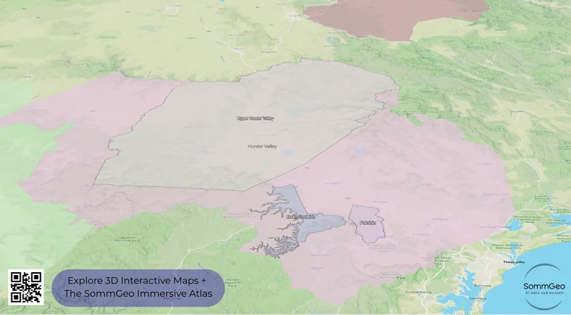
🌐 3D Mode + Hunter Valley
The Hunter Valley’s geographic logic only clicks in 3D. The Brokenback Range shelters Pokolbin from western weather systems while channeling afternoon sea breezes from the east, a cooling mechanism that rescues what would otherwise be too warm a climate for fine wine. Switch to 3D satellite and you’ll see why Broke Fordwich, tucked deeper into the hills, has different soils and a drier mesoclimate than the main Pokolbin strip.
✏️ Sketch + Presentation Building
Prepping a staff training on Australian wine? Drop labeled pins on each major GI, draw boundary highlights, add text annotations explaining regional character differences, and save the custom view. It’s a finished visual aid without opening PowerPoint. Use Save to export your annotated map as a downloadable image (uncheck “Include Legend” for a cleaner result).
Australia’s Wine Geography
Australia is a continent-sized wine country, and that scale creates challenges for anyone trying to understand it from a flat map. Vineyards stretch from the Hunter Valley at 32°S to Tasmania at 42°S (roughly the same latitudinal spread as from Sicily to Burgundy) and from Margaret River’s Indian Ocean coastline to the semi-arid Riverland interior. The GI system organizes this sprawl into 28 zones, 65 regions, and 14 officially recognized subregions, but the real geographic stories happen at scales that only an interactive tool can reveal.
South Australia is the engine room, producing nearly half the country’s wine. The Mount Lofty Ranges are the defining feature here; this north-south spine creates the Adelaide wine cluster, where you’ll find Barossa Valley, Eden Valley, Adelaide Hills, McLaren Vale, and Clare Valley all within an hour’s drive of each other but producing dramatically different wines because of elevation, aspect, and proximity to the ranges. The Barossa floor sits around 250–300 meters (820–984 ft) on ancient, weathered soils, some of the oldest commercially farmed Shiraz vines on earth live here. Adelaide Hills, just over the ridge, climbs above 500 meters (1,640 ft) with a completely different climate profile.
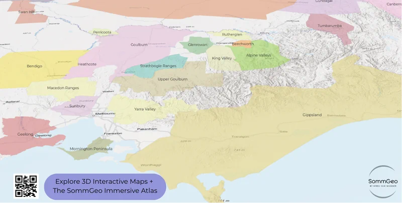
Victoria packs the most regional diversity into the smallest area. The Yarra Valley, Mornington Peninsula, Macedon Ranges, and Geelong are all cool-climate zones within easy reach of Melbourne, while inland regions like Heathcote and Bendigo produce warmer-climate Shiraz with genuine site character. Western Australia’s Margaret River sits in splendid isolation, a narrow coastal strip at the southwestern tip of the continent that produces some of the country’s most consistently excellent Cabernet Sauvignon and Chardonnay. And then there’s the Hunter Valley in New South Wales, Australia’s oldest wine region, where the seemingly unlikely combination of warm, humid conditions and ancient volcanic soils produces Semillon and Shiraz with a regional identity found nowhere else on earth.
Key Regions to Build
South Australia: Barossa, Eden Valley, Adelaide Hills & McLaren Vale
The Map Maker earns its keep around Adelaide, where the concentration of world-class GIs within such a compact area is extraordinary. Use the hillshade basemap to see how the Mount Lofty Ranges create the entire framework; Barossa Valley on the eastern rain shadow side, Adelaide Hills on the cooler western slopes, Eden Valley at the top of the range, and McLaren Vale wrapping around the southern end near the coast. Barossa Valley is, the spiritual home of Australian Shiraz. Penfolds, Henschke, Torbreck, and a lineage of producers stretching back to the 1840s farm some of the oldest Shiraz vines in the world, pre-phylloxera material that Europe lost entirely. The old vine vineyards around Marananga, Ebenezer, and Seppeltsfield produce wines of extraordinary concentration and depth.
Eden Valley, sitting at 400–500 meters (1,312–1,640 ft) above the Barossa floor, is Australia’s top Riesling: taut, precise, and built for aging. Henschke’s Hill of Grace vineyard, planted in the 1860s, sits here. Adelaide Hills brings the cool-climate contrast: Sauvignon Blanc, Chardonnay, and Pinot Noir thrive at altitude with the kind of natural acidity that the warm Barossa floor simply can’t deliver. Run the elevation profile tool from west to east across this cluster and the altitude shifts (and the wine style shifts with them) become immediately clear.
Victoria: Yarra Valley, Mornington Peninsula & Beyond
Victoria has arguably the most diverse collection of wine regions of any Australian state, and the 3D view is the best way to understand why. The Yarra Valley (Australia’s premier cool-climate Pinot Noir and Chardonnay address) sits in a natural amphitheater northeast of Melbourne where elevation varies from 50 meters (164 ft) on the valley floor to over 400 meters (1,312 ft) in the Upper Yarra. That range matters: lower sites produce riper, more generous styles while the upper valley delivers wines with tighter structure and finer aromatics. De Bortoli, Yering Station, Giant Steps, and Mac Forbes are all working the elevation gradient in different ways.
Mornington Peninsula, south of Melbourne on a narrow spit between Port Phillip Bay and Bass Strait, is maritime cool-climate at its most extreme; sea breezes from multiple directions keep temperatures in check and deliver Pinot Noir with a tension and salinity that’s hard to replicate elsewhere. Further afield, Beechworth in the Victorian Alps (home to Giaconda, one of Australia’s top Chardonnay producers) and Heathcote in the inland Cambrian soils produce completely different styles. The Map Maker lets you toggle between these scattered regions and compare their topographic settings at a glance.
Hunter Valley: Australia’s Oldest Wine Region
The Hunter Valley is a geographic paradox. At 32°S with warm, humid growing conditions and relatively low diurnal temperature variation, it shouldn’t produce world-class wine. And yet it does, particularly Semillon, a variety that has formed a bond with this specific site that has never been replicated anywhere else. Young Hunter Semillon is picked at relatively low sugar levels, fermented bone-dry with no oak, and released as a crisp, citrus-driven wine. Leave it in the cellar for a decade and it transforms into something extraordinary (toasty, honeyed, complex) through pure bottle development. It’s one of wine’s great party tricks.
The three official GI subregions (Pokolbin, Broke Fordwich, and Upper Hunter Valley) each have distinct characters. Pokolbin is the historic core, home to Tyrrell’s (whose Vat 1 Semillon set the benchmark), Brokenwood, and the original Lake’s Folly. Broke Fordwich, tucked behind the Brokenback Range, sits on volcanic red clay soils with lower rainfall and greater diurnal temperature variation than Pokolbin, producing fruit with a concentration that earned it status as Australia’s first officially designated subregion in 1997. The 3D outdoor basemap in the Map Maker is the ideal way to see how the Brokenback Range shapes these mesoclimates.
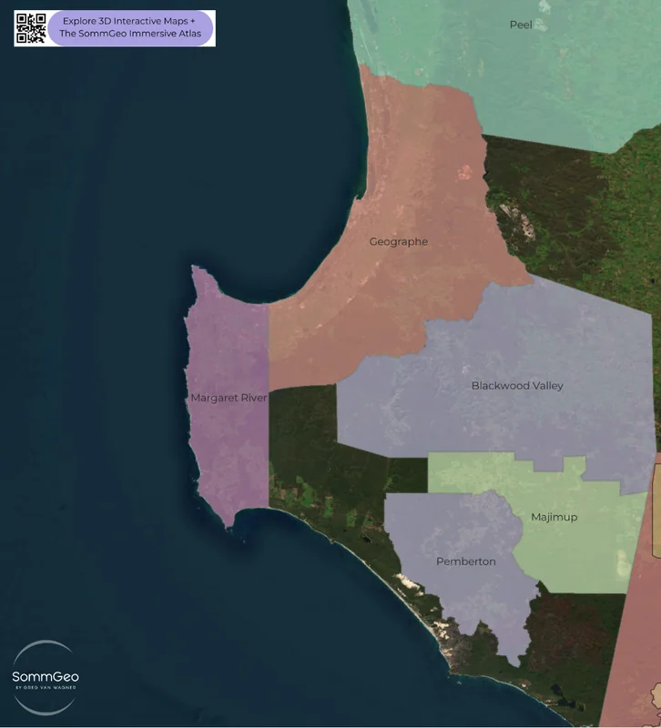
Western Australia: Margaret River & Great Southern
Margaret River’s geographic isolation is the first thing that hits you in the Map Maker. Zoom out and there’s simply nothing else for thousands of kilometers. This narrow strip of land between the Indian and Southern Oceans, just 100 kilometers (62 miles) long and 27 kilometers (17 miles) wide, produces some of the most consistently excellent Cabernet Sauvignon in the Southern Hemisphere. The maritime influence is total: the ocean moderates temperatures, delivers reliable rainfall, and creates a growing season that’s warm enough for Cabernet but cool enough for Chardonnay. Cullen, Vasse Felix, Leeuwin Estate, and Moss Wood have been proving this duality for decades.
Great Southern, further east along the coast, is Western Australia’s largest GI and arguably its most underrated. The five subregions (Frankland River, Mount Barker, Porongurup, Denmark, and Albany) produce Riesling, Shiraz, and Cabernet with genuine personality at a fraction of Margaret River’s pricing. The satellite view in the Map Maker shows just how different the two regions’ coastlines and hinterlands look.
New to the Map Makers? Explore all the tools, tips, and features in our complete walkthrough.
Map Maker Guide →Ready to build your own Australian wine maps? Join 200+ wine organizations already using SommGeo.
Start Your 15-Day Free Trial $5/month billed annually after trial · Cancel anytimePlease let us know what you think in the form below. Thanks!

