United States Wine Map Maker: Build Your Own AVA Maps
277 AVAs across 34 states. From Napa’s benchlands to the Finger Lakes, the Rocks District to the Texas High Plains. The entire American wine landscape, yours to explore and create.
The United States wine map is, frankly, enormous. With 277 federally recognized American Viticultural Areas spread across 34 states, it’s a viticultural landscape that ranges from the fog-cooled ridges of Sonoma Coast to the limestone peaks of Mt. Harlan, from the glacially carved Finger Lakes of New York to the volcanic soils of the Rogue Valley in Southern Oregon. California alone accounts for over 80% of national production and holds 154 AVAs; if it were a country, it would be the fourth-largest wine producer on the planet. But the real story for wine professionals goes far beyond California. Washington’s Columbia Valley, Oregon’s Willamette Valley, Virginia’s emerging scene, and the Finger Lakes’ world-class Rieslings are reshaping what American wine means. This Map Maker puts every one of those regions at your fingertips. Switch between 3D satellite, topographic relief, and classic cartographic views to build custom maps of any AVA in the country. Every mapped region includes detailed popup content covering grape varieties, climate profiles, soil types, viticulture, a sommelier-level reference built directly into the map.
Unlock the Full SommGeo Toolkit
Gain exclusive access to our entire suite of premium features, including interactive Map Makers, immersive 3D Tours, high-resolution classic Maps, and advanced analytical tools.
Start Free TrialWhat You’ll Explore
The United States Map Maker gives you full control over how you visualize American wine geography, but the real depth is in what each region reveals. Click on any mapped AVA and a comprehensive info panel opens with sommelier-level content: dominant grape varieties, climate and geographic profiles, soil composition, the viticultural specifics that define each appellation. Whether you’re reading about the alluvial benchland soils of Napa’s Rutherford, the basalt-driven vineyards of Washington’s Red Mountain, or the volcanic Jory soils of Oregon’s Dundee Hills, every mapped AVA carries this level of built-in intelligence. Beyond the content, switch between basemaps, measure distances, tilt perspectives, and save your custom compositions.
- All 277 federally recognized AVAs across 34 states with toggleable boundary layers
- In-depth AVA profiles for every mapped area: varieties, soils, climate
- Full 3D terrain with adjustable tilt and rotation. Right-click and drag to pan perspective
- Measurement tools for calculating distances between vineyards, towns, and geographic features
- Nested AVA hierarchy visible. Zoom from state-level regions down to individual sub-appellations
- Save and export custom map views for presentations, study materials, or client education
The American Wine Landscape
What makes the United States fascinating from a geographic perspective is the sheer range of growing conditions compressed into a single country. The AVA system (established in 1980 with Augusta, Missouri as the first designation) is built on a fundamentally geographic premise: that distinct climatic, geological, and topographic features create wines of distinguishable character. Unlike European appellations, AVAs don’t regulate grape varieties, yields, or winemaking methods. They simply say: this place is different from the place next to it. For wine professionals, understanding why it’s different is where SommGeo’s Map Maker becomes essential.
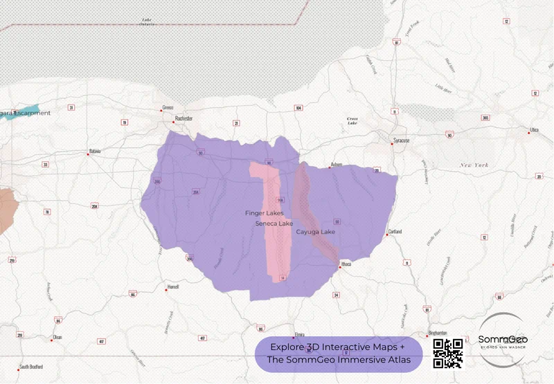
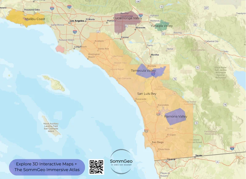
Consider the contrasts. In California’s Central Coast, the transverse mountain ranges run east-west rather than north-south, funneling cold Pacific air inland through gaps like the Santa Maria Valley, creating conditions cool enough for Pinot Noir just 150 miles (241 km) from the desert heat of the Inland Empire. In Washington, the Cascade Range creates a massive rain shadow that turns the Columbia Valley into a high-desert growing environment with intense sunlight, dramatic diurnal temperature swings, and almost zero rainfall during the growing season, the antithesis of western Oregon’s generally maritime Willamette Valley just a few hundred miles away. On the East Coast, the Finger Lakes’ deep glacial lakes moderate temperatures enough to ripen Riesling at the 42nd parallel, the same latitude as northern Spain. These are the kinds of geographic relationships that become immediately visible when you start building maps in 3D.
Key Regions to Explore
California: The Engine Room
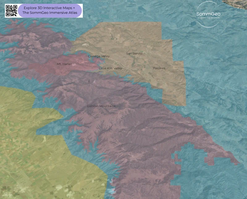
With 154 AVAs and over 4,000 wineries, California is less a single wine region than a continent unto itself. Napa Valley gets the headlines (and the prices), but the state’s real geographic diversity runs far deeper. The North Coast (Napa, Sonoma, Mendocino, Lake County) benefits from the constant push-pull between Pacific fog and inland warmth, creating the diurnal shifts that drive quality Cabernet Sauvignon in the warmer interior benchlands and Pinot Noir on the fog-cooled ridges. The Central Coast stretches over 250 miles (402 km) from the Santa Cruz Mountains to Santa Barbara County, encompassing everything from the limestone-rich micro-AVA of Mt. Harlan (home to Calera’s pioneering Pinot Noir at 2,200 feet (671 meters)) to the Rhône-inspired vineyards of Paso Robles. Use the Map Maker’s 3D satellite view to see how the transverse ranges create these radically different growing environments within a single coastal stretch.
The Pacific Northwest: Oregon & Washington
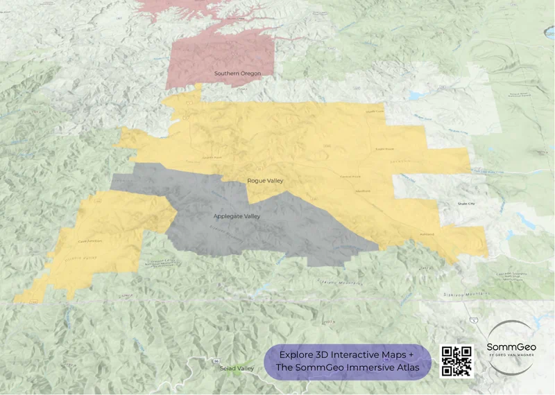
Oregon and Washington sit side by side but could hardly be more different in viticultural character. Oregon’s Willamette Valley is Pinot Noir and Chardonnay country: cool, wet winters, moderate summers, and volcanic Jory soils on the hillsides that produce wines of structure and restraint. Head south to the Rogue Valley and Umpqua Valley, and you’ll find Tempranillo, Syrah, and a wild diversity of warm-climate varieties thriving in the rain shadow of the Siskiyou Mountains. Washington’s story is almost entirely east of the Cascades: the Columbia Valley, Walla Walla, and Red Mountain, where volcanic soils and extreme diurnal shifts produce some of the most structured Cabernet and Syrah in the New World. The 3D topographic view makes the Cascade rain shadow (the single most important geographic feature in Pacific Northwest wine) impossible to miss.
The East Coast & Beyond
The Finger Lakes region of New York State is a stellar zone for Riesling. The deep glacial lakes (some reaching depths of over 600 feet (183 meters)) create a lake-effect microclimate that extends the growing season and protects vines from the brutal upstate winters. Producers like Dr. Konstantin Frank (whose founder proved vinifera could survive here in the 1960s), Hermann J. Wiemer, and Ravines have put this region on the world map. Virginia’s emerging scene around Charlottesville, Texas’ high-elevation vineyards in the Davis Mountains, and Michigan’s Lake Michigan Shore all represent the expanding frontier of American wine. The Map Maker lets you explore all of these regions with the same tools. Toggle between basemaps, zoom into specific AVAs, and build the geographic context that makes these wines make sense.
New to the Map Makers? Explore all the tools, tips, and features in our complete walkthrough.
Map Maker Guide →Ready to build custom maps of every U.S. wine region? Join 200+ wine organizations already using SommGeo.
Start Your 15-Day Free Trial $5/month billed annually after trial · Cancel anytimePlease let us know what you think in the form below. Thanks!

