Western Australia 3D Wine Map
Margaret River, Great Southern, Swan District, and the isolated wine regions of Australia’s west coast.
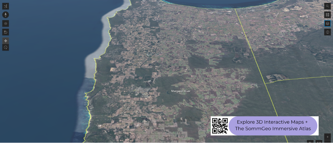
Western Australia’s wine regions are geographically isolated from the rest of the country, separated by thousands of kilometers of desert. That isolation has shaped a wine industry with a distinct identity, concentrated in the southwest corner of the state where the Indian and Southern Oceans meet. Margaret River dominates the conversation, but the broader Great Southern zone to the east covers a much larger area with its own set of growing conditions. This 3D Fast Map lets you see how the coastline, the Darling Scarp, and the southern ocean exposure define the landscape where these wines are grown.
Unlock the Full SommGeo Toolkit
Gain exclusive access to our entire suite of premium features, including interactive Map Makers, immersive 3D Tours, high-resolution classic Maps, and advanced analytical tools.
Start Free TrialWhat You’ll Explore
This 3D Fast Map covers Western Australia’s wine regions, from the Swan District near Perth south to Margaret River and east across the Great Southern zone. Click any mapped region for detailed popup content covering grape varieties, classification details, and geographic specifics.
- Full 3D terrain of Western Australia’s wine regions from Perth to the Great Southern >
- Elevation profile tool for measuring vineyard altitude and slope gradients
- Daylight and shadow animation to visualize aspect and sun exposure
- Detailed popup data for every mapped region: varieties, classifications, geography
Key Regions in Focus
Margaret River
Margaret River occupies a narrow strip of land on the cape where the Indian and Southern Oceans converge, roughly 270 kilometers (168 miles) south of Perth. The region’s geography is defined by ocean on three sides: no vineyard sits more than about 30 kilometers (19 miles) from the coast. That proximity delivers a strongly maritime climate with moderate temperatures, reliable rainfall, and persistent sea breezes that keep the growing season long and even. Soils are predominantly gravelly loam over granite and gneiss, with patches of laterite and limestone near the coast. Cabernet Sauvignon and Chardonnay are the region’s strongest suits, and Margaret River is also known for its Sauvignon Blanc/Semillon blends. Despite producing only around 2% of Australia’s total wine volume, the region accounts for a disproportionate share of the country’s premium output.
Great Southern
East of Margaret River, the Great Southern zone is one of the largest GIs in Australia by area, stretching roughly 200 kilometers (124 miles) along the southern coast and inland toward the Stirling and Porongurup Ranges. The zone contains five sub-regions, each with a different character: Frankland River sits further inland with a more continental influence and is known for Riesling, Shiraz, and Cabernet. Mount Barker, at slightly higher elevation, produces structured reds and aromatic whites. Porongurup, on the slopes of the Porongurup Range, is one of the cooler sites and favors Riesling and Pinot Noir. Albany and Denmark, closer to the coast, are the most maritime, with Denmark in particular drawing comparisons to cooler-climate regions for its Pinot Noir and Chardonnay. The 3D terrain shows clearly how the ranges and coastline create these distinct pockets within a single large zone.
New to 3D Fast Maps? Learn how to navigate 3D terrain, use elevation profiles, animate sunlight, and get the most from your map.
3D Fast Maps Guide →Ready to explore Western Australia’s wine regions in full 3D? Join 200+ wine organizations already using SommGeo.
Start Your 15-Day Free Trial $5/month billed annually after trial · Cancel anytimeMap Usage & Permissions
Personal Use
You are welcome to use, download, and share the maps on this site for personal, educational, and non-commercial purposes. If you share a map, please credit SommGeo with a link back to sommgeo.com.
Commercial Use
Use of these maps for any commercial purpose, including websites, print publications, marketing materials, or any other commercial venture, is strictly prohibited without prior written permission.
To inquire about custom SommGeo platforms, maps, or commercial licensing, please contact greg@sommgeo.com.

