Northwest Spain 3D Wine Map
Ribera del Duero, Rías Baixas, Toro, Bierzo, Rueda, and the wine regions of Castilla y León and Galicia in full 3D terrain.
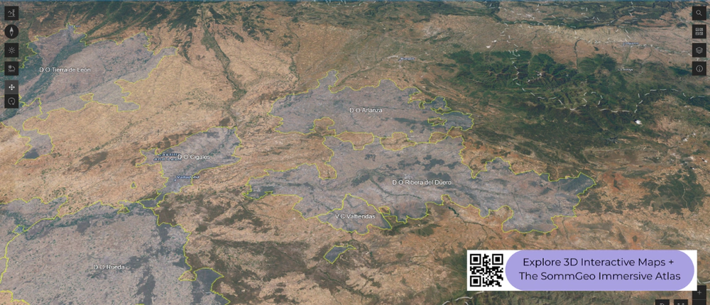
Northwest Spain splits into two fundamentally different wine worlds. The interior, dominated by the high Duero (Douro) river valley and the northern Meseta, produces powerful reds from Tempranillo (locally called Tinto Fino or Tinta de Toro) at altitudes of 700 to 900 meters (2,300 to 2,950 feet), where extreme continental conditions push the grape to its limits. The Atlantic coast of Galicia, by contrast, is green, wet, and cool, producing crisp, aromatic Albariño and Mencía in landscapes that feel closer to northern Portugal than to the Spanish interior. This map covers the DOs of Northwest Spain with detailed popup data. Use the layer controls to select shading or outlines and the elevation profile tool to trace the altitude gradients between the high plateau and the coastal lowlands.
Unlock the Full SommGeo Toolkit
Gain exclusive access to our entire suite of premium features, including interactive Map Makers, immersive 3D Tours, high-resolution classic Maps, and advanced analytical tools.
Start Free TrialWhat You’ll Explore
This 3D Fast Map covers the DOs of Northwest Spain, from the high Duero valley through Galicia’s Atlantic coast. Click any mapped DO for detailed popup content covering grape varieties, classification details, and geographic specifics. Use the layer controls to toggle different regional groupings on and off and the elevation profile tool to trace the dramatic altitude differences between the interior plateau and the coast.
- Northwest Spain’s DOs mapped with detailed popup data
- Elevation profile tool for measuring the plateau-to-coast altitude gradient
- Daylight and shadow animation to visualize aspect and sun exposure
- Detailed popup data for every mapped DO
Key Regions in Focus
Ribera del Duero and the Duero Valley
Ribera del Duero follows the Duero River for roughly 115 kilometers (71 miles) across the northern Meseta at 700 to 900 meters (2,300 to 2,950 feet). The extreme altitude creates the defining conditions: scorching summer days, cold nights with diurnal swings of 20°C (36 °F)or more, and harsh winters. Tempranillo (Tinto Fino) dominates, producing deeply colored, structured reds. Cigales, just west, shares the altitude but has shifted from rosé toward serious reds. Arlanza, between Ribera del Duero and the Cantabrian mountains, has more limestone influence. Toro, further downstream, sits at similar altitude but with sandier soils and even warmer conditions, producing Tinta de Toro of real power. The elevation profile tool is especially useful for understanding how the Duero carves through the plateau.
Galicia: Rías Baixas, Ribeira Sacra, and Valdeorras
Galicia is the geographic opposite of the interior. Rías Baixas produces Albariño in a wet, cool, maritime climate with granite soils and rainfall exceeding 1,600 millimeters (63 inches) per year. Vines are trained on pergolas (parrales) to promote airflow. The five sub-zones (Val do Salnés, Condado do Tea, O Rosal, Soutomaior, Ribeira do Ulla) each sit on different rías with varying maritime influence. Inland, Ribeira Sacra is one of Spain’s most dramatic landscapes: steep terraced slopes along the Sil and Miño gorges, where Mencía produces fragrant, medium-bodied reds on granite and slate. Valdeorras, further east, grows Godello on slate at higher elevation. In 3D, the contrast between the flat Galician coast and the deep river gorges of Ribeira Sacra is striking.
Rueda and Bierzo
Rueda sits on the Duero plain south of Valladolid at around 700 meters (2,300 feet), producing Spain’s benchmark Verdejo on stony, alluvial soils. The continental climate, with cold winters and hot summers, gives Verdejo its characteristic combination of herbal aromatics and crisp acidity. Bierzo, in the mountainous northwest corner of Castilla y León where it borders Galicia, is geographically and climatically closer to Galicia than to the Meseta. Mencía on slate and granite soils at 450 to 800 meters (1,475 to 2,625 feet) produces wines of increasing precision, and the recent focus on village and single-vineyard classifications is driving quality forward. The 3D terrain makes Bierzo’s mountain-ringed basin immediately visible and helps explain why this transitional zone produces wines distinct from both the Galician coast and the Duero plateau.
New to 3D Fast Maps? Learn how to navigate 3D terrain, use elevation profiles, animate sunlight, and get the most from your map.
3D Fast Maps Guide →Ready to explore Northwest Spain in full 3D? Join 200+ wine organizations already using SommGeo.
Start Your 15-Day Free Trial $5/month billed annually after trial · Cancel anytimeMap Usage & Permissions
Personal Use
You are welcome to use, download, and share the maps on this site for personal, educational, and non-commercial purposes. If you share a map, please credit SommGeo with a link back to sommgeo.com.
Commercial Use
Use of these maps for any commercial purpose, including websites, print publications, marketing materials, or any other commercial venture, is strictly prohibited without prior written permission.
To inquire about custom SommGeo platforms, maps, or commercial licensing, please contact greg@sommgeo.com.

