Argentina 3D Wine Map
Explore the highest commercially planted vineyards on earth, from Mendoza to Salta to Patagonia.
Argentina’s wine story is written in altitude. While most of the world’s vineyards sit below 500 meters (1,640 ft), Argentina’s climb routinely above 1,000 meters (3,280 ft), and in the northwest they push past 3,000 meters (9,842 ft) into territory no other major wine-producing country occupies. This 3D Fast Map covers every Argentine wine region of substance, letting you tilt, rotate, and fly through the Andean foothills and valley systems that define the country’s viticulture. See exactly how altitude, aspect, and proximity to the Andes shape the conditions on the ground.
Unlock the Full SommGeo Toolkit
Gain exclusive access to our entire suite of premium features, including interactive Map Makers, immersive 3D Tours, high-resolution classic Maps, and advanced analytical tools.
Start Free TrialWhat You’ll Explore
This 3D Fast Map covers Argentina’s wine-producing regions from the high desert of Salta in the north through the heartland of Mendoza to the cool valleys of Patagonia in the south. Click any mapped region for detailed popup content covering grape varieties, classification details, and geographic specifics. Use the layer controls to toggle different region groupings on and off.
- Full 3D terrain of Argentina’s wine regions from Salta to Patagonia
- Toggleable layers to control which region groupings are displayed
- Elevation profile tool for measuring vineyard altitude and slope gradients
- Daylight and shadow animation to visualize aspect and sun exposure
- Weather overlay to see how atmospheric conditions interact with terrain
- Detailed popup data for every mapped region: varieties, classifications, geography
Key Regions in Focus
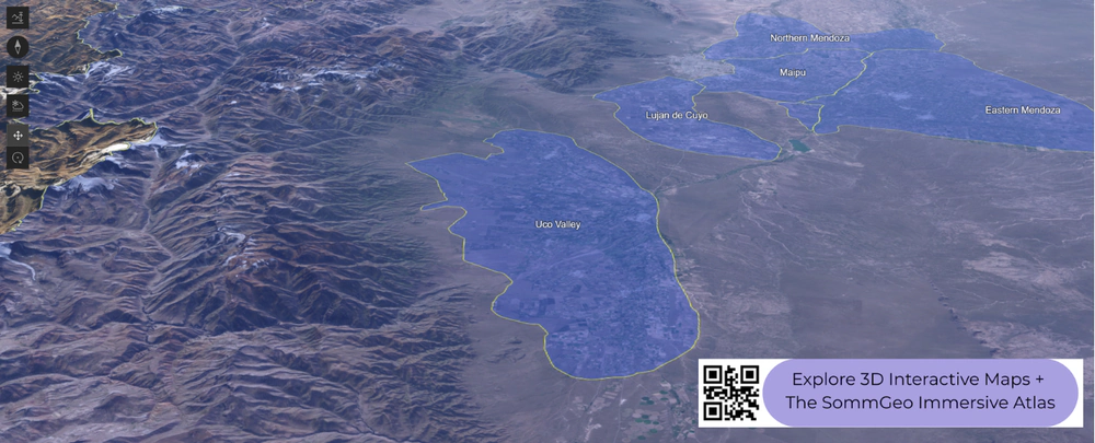
Mendoza and the Uco Valley
Mendoza accounts for roughly 70% of Argentina’s wine production and contains the country’s most important fine wine zones. The key geographic divide is between the traditional areas east of the city, Luján de Cuyo on the outskirts, and the Uco Valley to the south. Luján de Cuyo sits at around 900 to 1,100 meters (2,950 to 3,600 ft) on alluvial soils and has long been the benchmark for Argentine Malbec. The Uco Valley, by contrast, pushes higher: Altamira, Gualtallary, and the upper reaches of Tupungato regularly exceed 1,200 meters (3,937 ft), with some plantings above 1,500 meters (4,921 ft). The altitude brings wider diurnal temperature shifts, greater UV intensity, and the structured, aromatic wines that have reshaped Argentina’s fine wine reputation over the past two decades.
Salta and the Northwest
The Calchaquí Valley system in Salta and neighboring Catamarca is where Argentine viticulture reaches its vertical limits. Cafayate, the region’s commercial center, sits at roughly 1,700 meters (5,577 ft) and is the homeland of Torrontés, Argentina’s signature aromatic white. Further up the valley, vineyards above 3,000 meters (9,842 ft) are among the highest on the planet. At these elevations, intense solar radiation and dramatic day-to-night temperature swings produce wines of concentration and color depth from Malbec, Cabernet Sauvignon, and Tannat.
Patagonia
At the opposite end of the country, Río Negro and Neuquén in northern Patagonia offer a cool-climate counterpoint. Vineyards here sit at modest elevations (roughly 250 to 450 meters / 820 to 1,476 ft) but the high latitude (around 39°S) and persistent Patagonian winds create a genuinely cool growing season. Pinot Noir is the headline grape, alongside crisp expressions of Chardonnay, Merlot, and Semillón.
New to 3D Fast Maps? Learn how to navigate 3D terrain, use elevation profiles, animate sunlight, and get the most from your map.
3D Fast Maps Guide →Ready to explore Argentina’s wine regions in full 3D? Join 200+ wine organizations already using SommGeo.
Start Your 15-Day Free Trial $5/month billed annually after trial · Cancel anytimeMap Usage & Permissions
Personal Use
You are welcome to use, download, and share the maps on this site for personal, educational, and non-commercial purposes. If you share a map, please credit SommGeo with a link back to sommgeo.com.
Commercial Use
Use of these maps for any commercial purpose, including websites, print publications, marketing materials, or any other commercial venture, is strictly prohibited without prior written permission.
To inquire about custom SommGeo platforms, maps, or commercial licensing, please contact greg@sommgeo.com.

