
Bulgaria PDOs 3D Wine Map
Bulgaria’s ~52 officially registered Protected Designations of Origin mapped in 3D terrain.
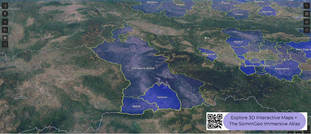
Bulgaria has roughly 52 registered PDOs (Protected Designations of Origin), though in practice these designations appear on labels far less often than the broader overarching regional names most drinkers encounter. This 3D Fast Map shows where each of those official PDOs sits in the landscape. For a country with one of the oldest winemaking traditions in Europe, going back to the ancient Thracians, the modern classification system is still developing, and these PDO boundaries represent the more granular, village- and district-level designations within Bulgaria’s wine geography.
Unlock the Full SommGeo Toolkit
Gain exclusive access to our entire suite of premium features, including interactive Map Makers, immersive 3D Tours, high-resolution classic Maps, and advanced analytical tools.
Start Free TrialWhat You’ll Explore
This 3D Fast Map shows Bulgaria’s officially registered PDO wine regions. These are the granular, district-level designations within Bulgaria’s classification system. Click any mapped PDO for detailed popup content covering grape varieties, classification details, and geographic specifics. Use the layer controls to toggle different groupings on and off. For Bulgaria’s broader overarching wine regions (the ones you’re more likely to see on labels),
see the companion Bulgaria: Overarching Regions 3D Fast Map.
- Full 3D terrain with all ~52 registered Bulgarian PDOs mapped
- Toggleable layers to control which PDO groupings are displayed
- Elevation profile tool for measuring vineyard altitude and slope gradients
- Daylight and shadow animation to visualize aspect and sun exposure
- Weather overlay to see how atmospheric conditions interact with terrain
- Detailed popup data for every mapped PDO: varieties, classifications, geography
Bulgaria’s PDO System in Context
A Classification Still Taking Shape
Bulgaria’s wine history stretches back thousands of years to the Thracians, who were noted as vigorous wine drinkers by the ancient Greeks. In more recent history, the communist era (1944 to 1989) reshaped the industry around large-scale cooperative production aimed at export volume, particularly to the Soviet Union. When that market collapsed, Bulgarian wine went through a difficult transition period. The modern classification system, aligned with EU standards after Bulgaria’s accession in 2007, established PDOs as the top tier of geographic designation. In practice, however, many producers still label under the broader PGI (Protected Geographical Indication) regional names or the overarching wine regions, which are better known internationally. The ~52 PDOs represent a more precise geographic layer that sees limited commercial use but provides a useful reference for understanding where specific vineyard areas sit within the broader landscape.
Notable PDOs
Among the registered PDOs, a handful have more recognition than the rest. Melnik, in the far southwest near the Greek border, is associated with the indigenous Shiroka Melnishka Loza (Broad-Leafed Melnik) grape and a warm, Mediterranean-influenced microclimate. Asenovgrad, near Plovdiv in the south-central part of the country, is tied closely to Mavrud, one of Bulgaria’s most distinctive indigenous red varieties. Suhindol, in the north, was historically known for Gamza (Kadarka) production. Khan Krum, in the northeast, and Karlovo, in the Sub-Balkan valleys, represent PDOs in different climatic zones. The 3D map lets you see how these individual PDOs relate to the surrounding topography, even if the names themselves don’t appear on bottles as often as the overarching regional designations.
New to 3D Fast Maps? Learn how to navigate 3D terrain, use elevation profiles, animate sunlight, and get the most from your map.
3D Fast Maps Guide →Ready to explore Bulgaria’s wine regions in full 3D? Join 200+ wine organizations already using SommGeo.
Start Your 15-Day Free Trial $5/month billed annually after trial · Cancel anytimeMap Usage
Free for your own study and tastings. If you share or teach with a map, credit it visibly as Map: SommGeo (sommgeo.com). Commercial use requires a Commercial Embed License. See Map Usage, Credit and Licensing.