Western Australia Wine Map: All 9 Regions in 3D, Interactive
Margaret River, Great Southern, Swan District, and the isolated wine regions of Australia’s west coast.
This interactive 3D Western Australia wine map shows all nine wine regions on real terrain, from the Swan District, Perth Hills and Peel around Perth down through Geographe, Margaret River on its cape and Blackwood Valley, Manjimup and Pemberton in the karri forests to the Great Southern in the southeast, with the six subregions marked: the Swan Valley and the Great Southern’s Frankland River, Mount Barker, Porongurup, Denmark and Albany, drawn in 3D by SommGeo. Tilt and fly along the coast, check elevation and slope, run the daylight animation and click any region for its grapes and profile. The interactive map is part of SommGeo membership, which starts with a free 15-day trial.
- Regions on the map: All 9 Western Australian GIs, every boundary clickable, plus the 6 subregions marked inside them
- Margaret River: A cape between the Indian and Southern Oceans about 270 km (170 miles) south of Perth, with no vineyard more than about 30 km (19 miles) from the sea, on gravelly loam over granite and gneiss
- Great Southern: One of the largest GIs in Australia by area, with five subregions on the map: Frankland River and Mount Barker inland, Porongurup on its granite peaks, Denmark and Albany on the coast
- Swan Valley: The oldest wine district in the state, planted in the 1830s on the flats east of Perth, hot and dry, the home of Chenin Blanc and Verdelho
- Signature grapes: Cabernet Sauvignon and Chardonnay in Margaret River; Riesling and Shiraz in the Great Southern; Chardonnay and Pinot Noir in Pemberton and Manjimup; Chenin Blanc and Verdelho around Perth
- 3D tools: Tilt and rotate the terrain, elevation profile readouts and daylight and shadow animation
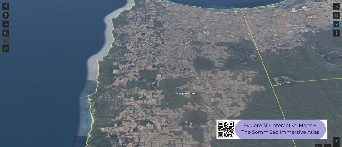
Western Australia’s wine regions are geographically isolated from the rest of the country, separated by thousands of kilometers of desert. That isolation has shaped a wine industry with a distinct identity, concentrated in the southwest corner of the state where the Indian and Southern Oceans meet. Margaret River dominates the conversation, but the broader Great Southern zone to the east covers a much larger area with its own set of growing conditions. This 3D Fast Map lets you see how the coastline, the Darling Scarp, and the southern ocean exposure define the landscape where these wines are grown.
Unlock the Full SommGeo Toolkit
Gain exclusive access to our entire suite of premium features, including interactive Map Makers, immersive 3D Tours, high-resolution classic Maps, and advanced analytical tools.
Start Free TrialWhat You’ll Explore
This 3D Fast Map covers Western Australia’s wine regions, from the Swan District near Perth south to Margaret River and east across the Great Southern zone. Click any mapped region for detailed popup content covering grape varieties, classification details, and geographic specifics.
- Full 3D terrain of Western Australia’s wine regions from Perth to the Great Southern >
- Elevation profile tool for measuring vineyard altitude and slope gradients
- Daylight and shadow animation to visualize aspect and sun exposure
- Detailed popup data for every mapped region: varieties, classifications, geography
Key Regions in Focus
Margaret River
Margaret River occupies a narrow strip of land on the cape where the Indian and Southern Oceans converge, roughly 270 kilometers (168 miles) south of Perth. The region’s geography is defined by ocean on three sides: no vineyard sits more than about 30 kilometers (19 miles) from the coast. That proximity delivers a strongly maritime climate with moderate temperatures, reliable rainfall, and persistent sea breezes that keep the growing season long and even. Soils are predominantly gravelly loam over granite and gneiss, with patches of laterite and limestone near the coast. Cabernet Sauvignon and Chardonnay are the region’s strongest suits, and Margaret River is also known for its Sauvignon Blanc/Semillon blends. Despite producing only around 2% of Australia’s total wine volume, the region accounts for a disproportionate share of the country’s premium output.
Great Southern
East of Margaret River, the Great Southern zone is one of the largest GIs in Australia by area, stretching roughly 200 kilometers (124 miles) along the southern coast and inland toward the Stirling and Porongurup Ranges. The zone contains five sub-regions, each with a different character: Frankland River sits further inland with a more continental influence and is known for Riesling, Shiraz, and Cabernet. Mount Barker, at slightly higher elevation, produces structured reds and aromatic whites. Porongurup, on the slopes of the Porongurup Range, is one of the cooler sites and favors Riesling and Pinot Noir. Albany and Denmark, closer to the coast, are the most maritime, with Denmark in particular drawing comparisons to cooler-climate regions for its Pinot Noir and Chardonnay. The 3D terrain shows clearly how the ranges and coastline create these distinct pockets within a single large zone.
Regions and subregions on this map (9 GIs, 6 subregions)
Every GI on the map, by zone, with the subregions the map marks at the end. The 3D map adds the terrain, elevation and sun tools plus a full profile for each.
| Region | Zone | Principal grapes |
|---|---|---|
| South West Australia | ||
| Margaret River | South West Australia | Cabernet Sauvignon, Chardonnay, Semillon-Sauvignon Blanc |
| Great Southern | South West Australia | Riesling, Shiraz, Cabernet Sauvignon, Chardonnay |
| Pemberton | South West Australia | Chardonnay, Pinot Noir, Sauvignon Blanc |
| Manjimup | South West Australia | Chardonnay, Pinot Noir, Cabernet Sauvignon |
| Blackwood Valley | South West Australia | Shiraz, Cabernet Sauvignon |
| Geographe | South West Australia | Shiraz, Cabernet Sauvignon, Chardonnay |
| Greater Perth | ||
| Swan District | Greater Perth | Chenin Blanc, Verdelho, Shiraz |
| Perth Hills | Greater Perth | Shiraz, Chardonnay, Verdelho |
| Peel | Greater Perth | Shiraz, Chardonnay, Chenin Blanc |
| Subregions marked on the map | ||
| Swan Valley | Swan District | Chenin Blanc, Verdelho, Shiraz, Grenache |
| Frankland River | Great Southern | Riesling, Shiraz, Cabernet Sauvignon |
| Mount Barker | Great Southern | Riesling, Shiraz, Cabernet Sauvignon |
| Porongurup | Great Southern | Riesling, Pinot Noir |
| Denmark | Great Southern | Chardonnay, Pinot Noir |
| Albany | Great Southern | Pinot Noir, Chardonnay, Riesling |
Hopefully this index is useful on its own. To explore these regions interactively, with every boundary on real terrain and a full profile for each, start a 15-day free trial. To see what one of these maps is like first, a different map is unlocked for everyone every day. For a flat view of every Australian region, see the Australia Fast Map; the South Australia 3D map covers the rest of the mainland’s big names.
Western Australia 3D Wine Map: Frequently Asked Questions
What are the wine regions of Western Australia?
Nine GIs in two zones, all in the far southwest corner of a very large state. Around Perth: the Swan District, with the historic Swan Valley inside it, the Perth Hills on the Darling Scarp and Peel to the south. In the South West Australia zone: Geographe on the coast below Bunbury, Margaret River on the cape, Blackwood Valley inland, Manjimup and Pemberton in the karri forest country, and the Great Southern, a huge region with five subregions of its own. All nine are on this map, with the six subregions marked.
Why is Margaret River compared with Bordeaux?
Because the climate matches on paper. A 1965 study by the agronomist John Gladstones pointed out that the cape’s growing season, moderated on three sides by ocean, runs close to Bordeaux in temperature but with less rain at harvest and almost no frost, and the first vines went in a couple of years later. Cabernet Sauvignon and Merlot blends and barrel-fermented Chardonnay became the region’s calling cards, with Semillon and Sauvignon Blanc blends in the Bordeaux white mould. The soils are the region’s own: gravelly loam over the granite and gneiss of the Leeuwin-Naturaliste ridge.
What are the Great Southern subregions?
Five, spread across a region that runs some 200 km (125 miles) from west to east. Frankland River, the most inland and continental, makes firm Riesling, Shiraz and Cabernet; Mount Barker, in the centre, is the Riesling benchmark with Shiraz alongside; Porongurup climbs the granite domes of the Porongurup Range for fine, mineral Riesling and Pinot Noir; Denmark, on the coast to the south, is the coolest and wettest, suited to Chardonnay and Pinot Noir; and Albany, by the Southern Ocean, is maritime and mild. All five are marked on the map.
What can the 3D map show that a flat map can’t?
You can tilt and rotate the terrain to see how flat and exposed the Margaret River cape is, the Darling Scarp rising behind the Swan Valley, the karri forest hills around Pemberton and the granite domes of the Porongurup and Stirling ranges standing out of the Great Southern plain. The elevation profile reads the climb from the Albany coast to Mount Barker and Frankland River, and the daylight animation shows which slopes of the Porongurup catch the sun. For a flat view of every Australian region, see the Australia Fast Map.
Is the Western Australia 3D wine map free?
The region index on this page is free to use. The interactive 3D map itself, with clickable boundaries and a full profile for every region, is part of SommGeo membership, which starts with a free 15-day trial. If you want a feel for what one of these maps is like before signing up, SommGeo unlocks one map every day on a rotation, different every day, no signup needed. Today’s unlocked map is on the home page.
New to 3D Fast Maps? Learn how to navigate 3D terrain, use elevation profiles, animate sunlight, and get the most from your map.
3D Fast Maps Guide →Ready to explore Western Australia’s wine regions in full 3D? Join 200+ wine organizations already using SommGeo.
Start Your 15-Day Free Trial $5/month billed annually after trial · Cancel anytimeMap Usage
Free for your own study and tastings. If you share or teach with a map, credit it visibly as Map: SommGeo (sommgeo.com). Commercial use requires a Commercial Embed License. See Map Usage, Credit and Licensing.
Map by Greg Van Wagner, SommGeo