
France Wine Map Maker: Interactive Guide
Over 360 appellations, a dozen distinct wine regions, and the birthplace of terroir, mapped, layered, and ready to explore.
France is where the conversation about terroir begins. With over 360 AOP appellations governed by the world’s most rigorous classification system, the country’s wine geography is both extraordinary and genuinely complex. From the gravel banks of Bordeaux’s Left Bank to the limestone slopes of Burgundy, from the granite hills of the Northern Rhône to the chalk cellars of Champagne, every region tells a different geographic story. This interactive France wine map lets you build your own study maps with toggleable AOP layers, elevation profiles, satellite imagery, and a solar aspect tool that simulates sunlight and shadow at any time of year. Whether you’re preparing for a certification exam or planning vineyard visits, this is the most detailed interactive map of French wine regions available. Every mapped appellation includes detailed popup content covering grape varieties, classification rules, climate and soil profiles, a sommelier-level reference built directly into the map.
Unlock the Full SommGeo Toolkit
Gain exclusive access to our entire suite of premium features, including interactive Map Makers, immersive 3D Tours, high-resolution classic Maps, and advanced analytical tools.
Start Free TrialFree to learn from. Credit when you share it.
Studying for an exam or just exploring on your own? It’s all yours, no credit needed. But if a map is going to be seen by others, used to teach, or put to any commercial use, we’d ask that you credit it prominently as Made with SommGeo Map Maker.
Building something bigger? We design licensed and co-branded maps for teams, associations, importers, and producers. Get in touch.
What You’ll Explore
The France Map Maker gives you full control over how you view and study the country’s appellation system, but the real depth is in what each region reveals. Click on any mapped AOP and a comprehensive info panel opens with sommelier-level content: permitted grape varieties, classification hierarchy, climate and soil profiles, and the geographic specifics that define each appellation. Whether you’re reading about the Kimmeridgean limestone driving Chablis’s mineral character, the gravel banks of the Haut-Médoc, or the granite of Hermitage’s hillside, every mapped appellation carries this level of built-in intelligence. Beyond the content, every AOP boundary is mapped in toggleable layers, and you can combine them with topographic data, satellite imagery, and analytical tools.
- All French AOP/AOC boundaries as toggleable layers. Load individual regions or the full national view
- In-depth appellation profiles for every mapped area: varieties, classification, soils, climate
- “Nested” vs. “Overarching” region options: view Burgundy’s commune-level AOPs without regional overlays, or Southern Rhône appellations without the Côtes du Rhône layer
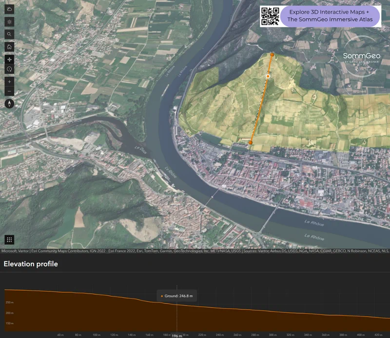
- Elevation profiles showing vineyard slope, aspect, and altitude across any cross-section
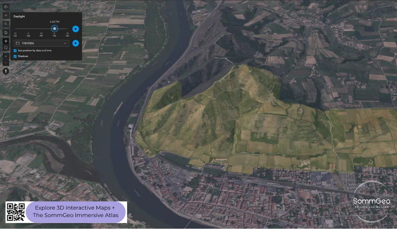
- Solar aspect tool: simulate sunlight and shadow patterns for any day of the year and time of day
- Sketch tools for adding study notes, pins, and annotations directly on the map
Performance tip: Showing all French AOPs at once can slow down older devices or slower connections. For the best experience, choose individual regional layers rather than loading everything simultaneously.

Geography and Terroir of France
What makes France’s wine geography exceptional isn’t just diversity; it’s the precision with which the French have catalogued it. The AOP system, born out of the establishment of INAO in 1935 (with Châteauneuf-du-Pape as the original template), doesn’t just draw lines on a map. It codifies the relationship between specific places and specific grapes, yields, and winemaking methods. Over 360 appellations later, no country on earth has mapped the connection between geography and wine with this level of detail.
The country’s wine regions span an enormous climatic range. The country’s wine regions span an enormous climatic range. Champagne pushes the northern limits of viable viticulture, where marginal ripening conditions are precisely the point; that struggle to reach full phenolic ripeness is what gives the base wines their nerve and acidity, the essential raw material for the region’s sparkling wines. Alsace sits at a similar latitude but operates in an entirely different register: sheltered behind the Vosges Mountains, it enjoys one of the driest, sunniest climates in France. Bordeaux and the Loire benefit from Atlantic moderation, while Burgundy sits in a continental climate where vintage variation is part of the story. The Rhône Valley transitions from continental north to Mediterranean south over just 200 kilometers (124 miles). And Languedoc-Roussillon and Provence bake under full Mediterranean sun, producing some of France’s most powerful (and increasingly refined) reds and rosés.
Geologically, the soil map reads like a textbook. Kimmeridgian limestone in Chablis, chalk in Champagne, gravel in the Médoc, granite in Beaujolais and the Northern Rhône, schist in Banyuls, galets roulés (round stones) in Châteauneuf-du-Pape, and the famously complex patchwork of marl, clay, and limestone that gives Burgundy’s Côte d’Or its vineyard-by-vineyard variation. The Map Maker’s elevation profile tool is particularly useful here. You can draw a cross-section through any hill to see exactly how slope, altitude, and aspect change across a single appellation.
Key Wine Regions
Bordeaux
One of the world’s most commercially important fine wine regions, with over 60 appellations organized around the Gironde estuary. The Left Bank (Médoc, Graves, Pessac-Léognan, Sauternes) sits on deep gravel beds that favor Cabernet Sauvignon, while the Right Bank (Saint-Émilion, Pomerol, Fronsac) features clay and limestone soils that produce Merlot-dominant blends. The 1855 Classification still drives the conversation here, though the Saint-Émilion classification (last revised in 2022) has generated its share of controversy. Producers to know: Château Latour, Château Cheval Blanc, Château Lafleur, Château Palmer.
Burgundy
If Bordeaux is classified by estate, Burgundy is classified by dirt. The Côte d’Or (that roughly 50-kilometer golden slope running from Dijon to Santenay) contains 33 Grand Cru vineyards and hundreds of Premier Cru plots, all mapped with specificity. Pinot Noir and Chardonnay reign here, and the difference between a village wine and a Grand Cru from the same commune can be a matter of meters and a completely different soil profile. The Map Maker’s nested layer option lets you view commune-level AOPs without the regional Bourgogne overlay cluttering the picture, essential for studying the hierarchy. Producers to know: Domaine de la Romanée-Conti, Domaine Leroy, Coche-Dury, Domaine Roulot.
Champagne
The northernmost major wine region in France, where chalk subsoils and a cool, marginal climate create the conditions for the world’s most celebrated sparkling wine. The region’s classification system is village-based (Grand Cru, Premier Cru), and the three primary grape varieties (Chardonnay, Pinot Noir, and Pinot Meunier) are distributed across three main sub-regions: the Côte des Blancs for Chardonnay, the Montagne de Reims and Aube for Pinot Noir, and the Vallée de la Marne for Meunier (generally speaking). The grower Champagne movement has transformed how professionals think about the region’s terroir over the past two decades.
The Rhône Valley
Two regions in one. The Northern Rhône is a narrow granite corridor producing some of France’s most singular Syrah (Hermitage, Côte-Rôtie, Cornas) and exceptional Viognier from Condrieu. The Southern Rhône is broader and Mediterranean, dominated by Grenache-based blends across vast appellations like Châteauneuf-du-Pape and Gigondas. The Map Maker’s “overarching vs. nested” view is particularly useful here. You can strip away the regional Côtes du Rhône layer to focus on the individual crus without the visual noise.
Loire Valley
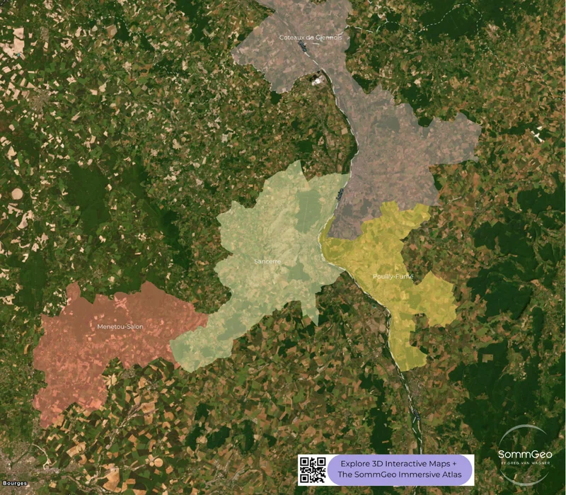
France’s longest wine river, stretching from the volcanic soils of the Auvergne to the Atlantic coast near Nantes. The Loire produces everything from bone-dry Muscadet sur Lie to the botrytized sweet wines of Quarts de Chaume, with world-class Sauvignon Blanc from Sancerre and Pouilly-Fumé and increasingly serious Cabernet Franc from Chinon, Bourgueil, and Saumur-Champigny in between. The Central Vineyards around Sancerre (visible in the satellite view screenshot) sit on the same Kimmeridgian limestone found in Chablis, which is no coincidence.
Alsace
Tucked between the Vosges mountains and the Rhine, Alsace is France’s driest major wine region; the mountains create a pronounced rain shadow. The region is unique in France for labeling by grape variety (Riesling, Gewurztraminer, Pinot Gris, Muscat), and its 51 Grand Cru vineyards are defined by an extraordinary geological mosaic: granite, limestone, sandstone, volcanic, and clay soils can shift within a single hillside. This is one of the most rewarding regions to study with the elevation and solar aspect tools.
Languedoc-Roussillon & Provence
The south of France has undergone a quality revolution. Languedoc remains France’s largest wine-producing area by volume, but the best producers in appellations like Pic Saint-Loup, La Clape, Faugères, and Minervois are making structured, terroir-driven wines that punch well above their price point. Roussillon adds the dry schist-based wines of Maury and Collioure, plus some of France’s finest Vins Doux Naturels. Provence, meanwhile, has become a global standard-bearer for rosé while its red appellations (Bandol, above all) produce some of the most serious wines in the Mediterranean south.
New to the Map Makers? Explore all the tools, tips, and features in our complete walkthrough.
Map Maker Guide →Ready to explore France’s appellations in full detail? Join 200+ wine organizations already using SommGeo.
Start Your 15-Day Free Trial $5/month billed annually after trial · Cancel anytimePlease let us know what you think in the form below. Thanks!