Priorat 3D Wine Map: The 12 Vi de Vila Zones on Real Terrain
Every village zone of Priorat, from Gratallops and Porrera to Escaladei and La Morera de Montsant, mapped on the 3D terrain of the hills below the Montsant.
This interactive 3D map shows the 12 Vi de Vila zones of Priorat DOQ on real terrain, inside the outline of the denomination, drawn in 3D by SommGeo. Tilt and fly over the valleys of the Siurana, the Montsant and the Cortiella, check elevation and slope, and run the daylight and shadow animation to see which way each slope faces. Click any zone for its profile. The interactive map is part of SommGeo membership, which starts with a free 15-day trial.
- On the map: 12 Vi de Vila zones and the Priorat DOQ outline
- Grapes: Garnatxa and Carinyena (Samsó) are the recommended red grapes
- Zone: Nine whole municipalities plus the northern part of Falset and the eastern part of El Molar, in the province of Tarragona
- Land: 17,629 hectares (about 43,560 acres), of which about 2,200 (5,400 acres) are planted to vines
- Vi de Vila: Since the 2007 vintage, for wines made entirely from one zone, with reds at least 60% Carinyena, Garnatxa Negra, Garnatxa Peluda or Picapoll Negre
- 3D tools: Tilt and rotate the terrain, elevation and slope readouts, daylight and shadow animation and a weather overlay
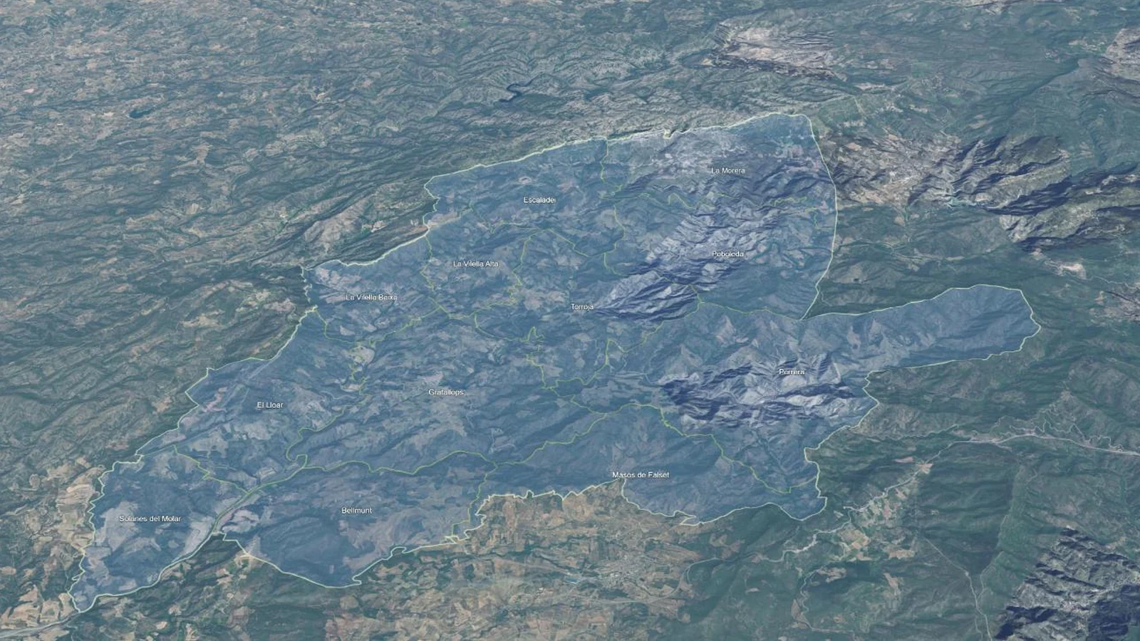
Priorat is small and mountainous. The Montsant massif closes it to the north, the Siurana river crosses it from northeast to southwest, and most vineyards sit on steep slopes of llicorella, the local slate. The 12 zones the Consell Regulador has drawn around its villages are hard to read on a flat map. In 3D the pattern shows: which zones sit beneath the cliffs of the Montsant, which follow a single river valley, and which hold the warmer ground in the south and west. This map puts every zone into interactive terrain, each with its own profile.
Unlock the Full SommGeo Toolkit
Gain exclusive access to our entire suite of premium features, including interactive Map Makers, immersive 3D Tours, high-resolution classic Maps, and advanced analytical tools.
Start Free TrialWhat You’ll Explore
This 3D Fast Map contains the 12 Vi de Vila zones of Priorat as one layer, plus the outline of the DOQ. Click any zone for its profile: where it sits, which rivers run through it, a note on the village and the municipalities its parcels are drawn from. Search by zone to fly straight to it. A search for Scala Dei finds Escaladei as well. Use the elevation profile to measure a slope from river to ridge, and the daylight animation to compare how neighboring zones catch the sun.
- All 12 Vi de Vila zones of Priorat mapped individually
- Boundaries from the Consell Regulador’s own delimitation of the zones
- Search by zone or appellation, with the map flying to the area
- Elevation profile tool for measuring vineyard altitude and slope gradients
- Daylight and shadow animation to visualize aspect and sun exposure by zone
- A north-facing opening view of the whole denomination
Key Areas in Focus
The Northern Zones Below the Montsant
La Morera de Montsant is the northernmost of the 12 zones, set directly beneath the cliffs of the Serra de Montsant. Escaladei, to its west, is the historic heart of the region: Carthusian monks founded the Cartoixa d’Escaladei in 1194 and built it at the foot of the Montsant from about 1203, and the lands of its prior gave Priorat its name. Escaladei is a hamlet of the municipality of La Morera de Montsant, and that one municipality is split among four zones. The Riuet d’Escaladei runs down through La Vilella Alta and meets the Montsant river at La Vilella Baixa. Poboleda, the second-largest zone by land area, lies in the upper valley of the Siurana. La Morera de Montsant, Poboleda and La Vilella Alta are counted among the cooler parts of Priorat.
The Siurana Valley, Porrera and the South
Torroja del Priorat, seat of the Consell Regulador, occupies the middle of the denomination with the Siurana winding through it. Gratallops sits at the center, touches seven other zones, and holds the point where the Cortiella river joins the Siurana. Porrera, the largest zone by land area with about 18% of the mapped territory, fills the valley of the Cortiella in the east and is also counted among the cooler parts. Farther south and west, El Lloar follows the lower course of the Montsant river and Bellmunt del Priorat lies where the Siurana meets it: the two are counted among the warmest parts of Priorat. Masos de Falset and Solanes del Molar, on the southern edge, are the two zones without a village of their own. Use the elevation profile to compare them with the zones below the Montsant.
Regions on this map (13)
Every Vi de Vila zone on the map, with the municipalities it is drawn from. The 3D map adds the terrain plus a full profile for each.
| Region | Drawn from |
|---|---|
| Vi de Vila zones (12) | |
| Bellmunt del Priorat | Bellmunt del Priorat, with parcels of Falset |
| Escaladei | La Morera de Montsant (Escaladei) and parcels of Torroja del Priorat |
| Gratallops | Gratallops, with parcels of El Lloar, Porrera, Torroja del Priorat and Falset |
| El Lloar | El Lloar, with parcels of El Molar and Gratallops |
| La Morera de Montsant | La Morera de Montsant, with parcels of Poboleda |
| Poboleda | Poboleda, with parcels of La Morera de Montsant and Porrera |
| Porrera | Porrera, with parcels of Falset |
| Torroja del Priorat | Torroja del Priorat, with parcels of Porrera and Gratallops |
| La Vilella Alta | La Vilella Alta, with parcels of Torroja del Priorat and La Morera de Montsant |
| La Vilella Baixa | La Vilella Baixa, with parcels of Gratallops and El Lloar |
| Masos de Falset | Northern part of Falset |
| Solanes del Molar | Eastern part of El Molar |
| Appellation (1) | |
| Priorat DOQ | Province of Tarragona, Catalonia |
Hopefully this index is useful on its own. To explore these regions interactively, with every boundary on real terrain and a full profile for each, start a 15-day free trial. To see what one of these maps is like first, a different map is unlocked for everyone every day.
Priorat 3D Wine Map: Frequently Asked Questions
How many Vi de Vila zones are there in Priorat?
Twelve: Bellmunt del Priorat, Escaladei, Gratallops, El Lloar, La Morera de Montsant, Poboleda, Porrera, Torroja del Priorat, La Vilella Alta, La Vilella Baixa, Masos de Falset and Solanes del Molar. Ten are named for a village or, in the case of Escaladei, a hamlet. Masos de Falset and Solanes del Molar are made up of land in the municipalities of Falset and El Molar, whose villages stand outside the denomination. This map shows all 12, inside the outline of Priorat DOQ.
What is a Vi de Vila?
A Vi de Vila is a Priorat wine made entirely from grapes grown in one of the 12 zones, and it may carry that zone’s name on the label. The category dates from the 2007 vintage. Reds must be at least 60% Carinyena, Garnatxa Negra, Garnatxa Peluda or Picapoll Negre, alone or together. Above it in the classification sit Vi de Paratge, Vinya Classificada and Gran Vinya Classificada.
Do the Vi de Vila zones follow municipal boundaries?
Not exactly. The Consell Regulador drew each zone around the growing landscape of its village, so parcels of one municipality can belong to a neighboring zone. The Gratallops zone, for example, takes in parcels of El Lloar, Porrera, Torroja del Priorat and Falset, and the Escaladei zone combines the western part of the municipality of La Morera de Montsant with parcels of Torroja del Priorat. The region index on this page lists what each zone is drawn from.
What can the 3D map show that a flat map can’t?
You can tilt and rotate the terrain, read elevation and slope gradients, animate daylight and shadows to see each zone’s aspect and sun exposure, and add a weather overlay. For a flat view of the whole country, see the Spain Fast Map.
Is the Priorat 3D wine map free?
The region index on this page is free to use. The interactive 3D map itself, with clickable boundaries and a full profile for every region, is part of SommGeo membership, which starts with a free 15-day trial. If you want a feel for what one of these maps is like before signing up, SommGeo unlocks one map every day on a rotation, different every day, no signup needed. Today’s unlocked map is on the home page.
New to 3D Fast Maps? Learn how to navigate 3D terrain, use elevation profiles, animate sunlight, and get the most from your map.
3D Fast Maps Guide →Ready to explore every Vi de Vila zone of Priorat in full 3D? Join 200+ wine organizations already using SommGeo.
Start Your 15-Day Free Trial $5/month billed annually after trial · Cancel anytimeMap Usage
Free for your own study and tastings. If you share or teach with a map, credit it visibly as Map: SommGeo (sommgeo.com). Commercial use requires a Commercial Embed License. See Map Usage, Credit and Licensing.
Map by Greg Van Wagner, SommGeo