Hermitage 3D Wine Map: All 20 Lieux-Dits on Real Terrain
Every lieu-dit of the hill of Hermitage, from Les Bessards and L’Hermite to Le Méal, Les Rocoules and La Croix, mapped on 3D terrain above the Rhône.
This interactive 3D map shows all 20 lieux-dits of Hermitage on real terrain, with the outline of the appellation and the Crozes-Hermitage area around it, drawn in 3D by SommGeo. Tilt and fly over the hill above Tain-l’Hermitage, check elevation and slope, and run the daylight and shadow animation to see how each lieu-dit faces the sun. Click any lieu-dit and a profile opens with its commune, position and site notes. The interactive map is part of SommGeo membership, which starts with a free 15-day trial.
- Lieux-dits on the map: 20. Tain-l’Hermitage (18), Crozes-Hermitage (1) and Larnage (1)
- Grapes: Syrah for reds, Marsanne and Roussanne for whites
- Appellation: Hermitage AOP, recognized in 1937, on the left bank of the Rhône in the Drôme
- Size: 137 hectares in production in 2025, according to Inter Rhône
- Soils: Granite in the west of the hill, old alluvial terraces in the east
- 3D tools: Tilt and rotate the terrain, elevation and slope readouts, daylight and shadow animation and a weather overlay
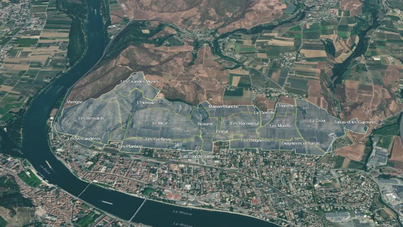
Hermitage is one hill. It rises straight above the town of Tain-l’Hermitage on a bend of the Rhône, faces south, and holds all 20 lieux-dits of the appellation on a slope you can walk across in an afternoon. On a flat map the names sit side by side. In 3D the hill explains itself: the steep granite flank at the western end, the ridge along the top, the terraces stepping down toward the town, and the eastern end running toward Larnage. This map puts every lieu-dit into interactive terrain, each with its commune and site notes.
Unlock the Full SommGeo Toolkit
Gain exclusive access to our entire suite of premium features, including interactive Map Makers, immersive 3D Tours, high-resolution classic Maps, and advanced analytical tools.
Start Free TrialWhat You’ll Explore
This 3D Fast Map contains all 20 lieux-dits of Hermitage, the outline of the Hermitage appellation and the Crozes-Hermitage area around it. Click any lieu-dit for its profile: commune, position, delimited area and site notes. Search by name to fly straight to a site. Use the elevation profile to measure the slope from the foot of the hill to the ridge, and the daylight animation to compare how neighboring lieux-dits catch the sun.
- All 20 lieux-dits of Hermitage mapped individually
- The Hermitage outline and the surrounding Crozes-Hermitage area
- Search by lieu-dit or appellation, with the map flying to the site
- Commune, delimited area and site notes in every profile
- Elevation profile tool for measuring vineyard altitude and slope gradients
- Daylight and shadow animation to visualize aspect and sun exposure by lieu-dit
Key Areas in Focus
Les Bessards, L’Hermite and Le Méal
The western end of the hill is granite, a fragment of the massif that the Rhône cut off from the Ardèche side. Les Bessards covers that flank and, at about 21 hectares, is the largest of the 20 lieux-dits by delimited area. L’Hermite runs along the top of the hill, where the chapel of Saint-Christophe stands. Below it, Le Méal holds the south-facing middle of the slope on old alluvial deposits topped with rounded pebbles, with Les Greffieux on the lower ground beneath. Tilt the map to see how these four stack from the ridge down to the town.
The Eastern Lieux-Dits and Crozes-Hermitage
The granite ends at Les Bessards, and old alluvial terraces take over to the east. Beaume, Péléat, Les Rocoules and Les Murets follow one another across the middle of the hill, and La Croix, the second largest lieu-dit by delimited area, fills the eastern end. Inter Rhône singles out Les Murets and Les Diognières as white wine sites, on clay soils and gentler slopes. Around the hill the map shows Crozes-Hermitage, which spreads across 11 communes: granite slopes to the north around Gervans, Erôme and Serves-sur-Rhône, and flat terraces of rounded pebbles to the south and east.
Lieux-dits on this map (20)
Every lieu-dit on the map, by commune, plus the two appellations shown. The 3D map adds the terrain plus a full profile for each.
| Lieu-dit | Commune |
|---|---|
| Tain-l’Hermitage (18 lieux-dits) | |
| Beaume | Tain-l’Hermitage |
| Diognières et Torras | Tain-l’Hermitage |
| L’Hermite | Tain-l’Hermitage |
| L’Homme | Tain-l’Hermitage |
| La Croix | Tain-l’Hermitage |
| La Croix de Jamanot | Tain-l’Hermitage |
| La Pierrelle | Tain-l’Hermitage |
| Le Méal | Tain-l’Hermitage |
| Les Bessards | Tain-l’Hermitage |
| Les Diognières | Tain-l’Hermitage |
| Les Greffieux | Tain-l’Hermitage |
| Les Murets | Tain-l’Hermitage |
| Les Plantiers | Tain-l’Hermitage |
| Les Rocoules | Tain-l’Hermitage |
| Les Vercandières | Tain-l’Hermitage |
| Maison Blanche | Tain-l’Hermitage |
| Péléat | Tain-l’Hermitage |
| Varogne | Tain-l’Hermitage |
| Crozes-Hermitage (1 lieu-dit) | |
| Les Grandes Vignes | Crozes-Hermitage |
| Larnage (1 lieu-dit) | |
| Torras et les Garennes | Larnage |
| Appellations (2) | |
| Hermitage AOP | Tain-l’Hermitage, Crozes-Hermitage, Larnage |
| Crozes-Hermitage AOP | 11 communes of the Drôme |
Hopefully this index is useful on its own. To explore these regions interactively, with every boundary on real terrain and a full profile for each, start a 15-day free trial. To see what one of these maps is like first, a different map is unlocked for everyone every day.
Hermitage 3D Wine Map: Frequently Asked Questions
How many lieux-dits are there in Hermitage?
Twenty. The French land register divides the appellation’s delimited vineyard land among 20 named lieux-dits. Eighteen lie in the commune of Tain-l’Hermitage. Les Grandes Vignes is in Crozes-Hermitage and Torras et les Garennes is in Larnage. The appellation rules set no ranking among them, and a wine labeled Hermitage may come from any one of them or from a blend of several.
What grapes are grown in Hermitage?
Syrah for the reds, Marsanne and Roussanne for the whites. A red Hermitage must be at least 85% Syrah, and up to 15% Marsanne and Roussanne may be fermented together with it. The appellation also allows a rare white vin de paille, made from grapes dried for at least 45 days before pressing.
What is the difference between Hermitage and Crozes-Hermitage?
Hermitage is a single south-facing hill above Tain-l’Hermitage, with 137 hectares in production in 2025 according to Inter Rhône. Crozes-Hermitage lies around it to the north, east and south, across 11 communes of the Drôme and had 2,139 hectares in production the same year. Both use the same three grapes. This map shows the Crozes-Hermitage area around the hill so you can see where one appellation ends and the other begins.
What can the 3D map show that a flat map can’t?
You can tilt and rotate the terrain, read elevation and slope gradients, animate daylight and shadows to see each lieu-dit’s aspect and sun exposure, and add a weather overlay. For a flat view of the whole country, see the France Fast Map.
Is the Hermitage 3D wine map free?
The region index on this page is free to use. The interactive 3D map itself, with clickable boundaries and a full profile for every region, is part of SommGeo membership, which starts with a free 15-day trial. If you want a feel for what one of these maps is like before signing up, SommGeo unlocks one map every day on a rotation, different every day, no signup needed. Today’s unlocked map is on the home page.
New to 3D Fast Maps? Learn how to navigate 3D terrain, use elevation profiles, animate sunlight, and get the most from your map.
3D Fast Maps Guide →Ready to explore every lieu-dit of Hermitage in full 3D? Join 200+ wine organizations already using SommGeo.
Start Your 15-Day Free Trial $5/month billed annually after trial · Cancel anytimeMap Usage
Free for your own study and tastings. If you share or teach with a map, credit it visibly as Map: SommGeo (sommgeo.com). Commercial use requires a Commercial Embed License. See Map Usage, Credit and Licensing.
Map by Greg Van Wagner, SommGeo