Côte-Rôtie 3D Wine Map: All 73 Lieux-Dits on Real Terrain
Every lieu-dit of Côte-Rôtie, from Côte Brune and Côte Blonde to the plateau edge, mapped on the 3D terrain of the Rhône’s right bank.
This interactive 3D map shows all 73 lieux-dits of Côte-Rôtie on real terrain, across the three communes of Saint-Cyr-sur-le-Rhône, Ampuis and Tupin-et-Semons, drawn in 3D by SommGeo. Tilt and fly along the Rhône, check elevation and slope, and run the daylight and shadow animation to see how each side valley turns the slope. Click any lieu-dit and a profile opens with its commune, elevation, exposure and site notes. The interactive map is part of SommGeo membership, which starts with a free 15-day trial.
- Lieux-dits on the map: 73, in Saint-Cyr-sur-le-Rhône (11), Ampuis (49) and Tupin-et-Semons (13)
- Grapes: Syrah, with up to 20% Viognier vines interplanted and fermented with it
- Soils: Mica-schist in the north, gneiss in the south and migmatite at the far southern end
- Vineyard area: 342 ha in production in 2025, according to Inter Rhône
- Terrain: Terraced slopes on the right bank of the Rhône, with the mapped lieux-dits running from about 150 m by the river to about 360 m at the plateau edge
- 3D tools: Tilt and rotate the terrain, elevation and slope readouts, daylight and shadow animation and a weather overlay
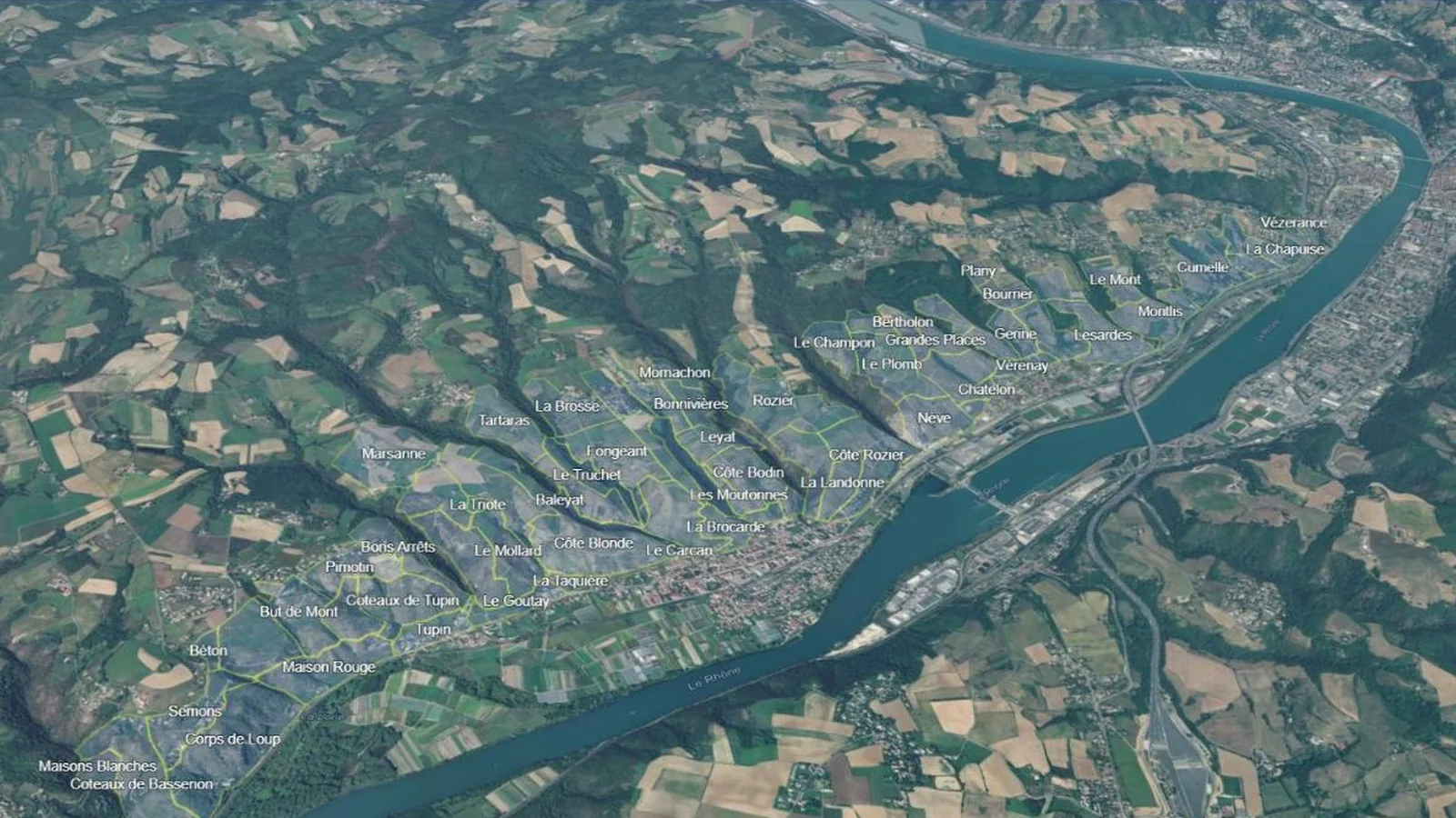
From the river Côte-Rôtie looks like one long hillside, but it is not a simple one. The appellation follows the right bank of the Rhône for about eight kilometers, and its general exposure is southeast. A series of streams cuts back into the plateau, and each side valley turns part of the slope to face south, southwest or even northeast. The lieux-dits follow those folds. In 3D the pattern is easy to read: which sites sit at the foot of the hill, which climb the full slope, and which lie on the gentler ground at the plateau edge. This map puts every lieu-dit into interactive terrain, each with its commune, elevation range and exposure.
Unlock the Full SommGeo Toolkit
Gain exclusive access to our entire suite of premium features, including interactive Map Makers, immersive 3D Tours, high-resolution classic Maps, and advanced analytical tools.
Start Free TrialWhat You’ll Explore
This 3D Fast Map contains all 73 lieux-dits of Côte-Rôtie. Click any lieu-dit for its profile: commune, elevation range, exposure and site notes. Search by name to fly straight to a site. Use the elevation profile to measure a slope from the river to the plateau, and the daylight animation to compare how neighboring lieux-dits catch the sun.
- All 73 lieux-dits of Côte-Rôtie mapped individually
- Search by lieu-dit, with the map flying to the site
- Commune, elevation range and exposure in every profile
- Elevation profile tool for measuring vineyard altitude and slope gradients
- Daylight and shadow animation to visualize aspect and sun exposure by lieu-dit
- A north-facing opening view with the whole appellation in frame
Key Areas in Focus
Côte Brune and Côte Blonde
Two names define the traditional division of Côte-Rôtie: the slopes directly above the town of Ampuis, on either side of the Reynard stream. Côte Brune, on the north side, sits on mica-schist under dark, iron-rich soil, worked in narrow terraces known locally as chaillées. Côte Blonde, on the south side, sits mostly on gneiss under pale, crumbly clay-sand soil called arzel, held by dry stone walls called cheys. On the map the two lieux-dits do not face the same way: Côte Brune looks southwest across the stream, and Côte Blonde looks south. Both names are also used more loosely for the northern and southern halves of the appellation, and the 3D view shows why the line falls where it does.
From Saint-Cyr-sur-le-Rhône to Tupin-et-Semons
Ampuis holds 49 of the 73 lieux-dits, with 11 to the north in Saint-Cyr-sur-le-Rhône and 13 to the south in Tupin-et-Semons. Position on the slope varies as much as position along the river. Small lieux-dits such as La Taquière and Le Goutay sit at the foot of the hill around 150 to 170 m. Steep sites such as La Landonne, Côte Rozier and Le Combard climb from the foot of the slope toward 300 m. Others, such as Marsanne and Le Champin, lie on gentler ground at the plateau edge above 300 m. At the far southern end, Coteaux de Bassenon touches the Condrieu appellation. Use the elevation profile to compare them.
Lieux-dits on this map (73)
Every lieu-dit on the map, by commune, north to south. The 3D map adds the terrain plus a full profile for each.
| Lieu-dit | Commune |
|---|---|
| Saint-Cyr-sur-le-Rhône (11 lieux-dits) | |
| Bourrier | Saint-Cyr-sur-le-Rhône |
| Cumelle | Saint-Cyr-sur-le-Rhône |
| La Chapuise | Saint-Cyr-sur-le-Rhône |
| La Servonnière | Saint-Cyr-sur-le-Rhône |
| Le Mont | Saint-Cyr-sur-le-Rhône |
| Le Remilly | Saint-Cyr-sur-le-Rhône |
| Le Village | Saint-Cyr-sur-le-Rhône |
| Montlis | Saint-Cyr-sur-le-Rhône |
| Plany | Saint-Cyr-sur-le-Rhône |
| Planèze | Saint-Cyr-sur-le-Rhône |
| Vézerance | Saint-Cyr-sur-le-Rhône |
| Ampuis (49 lieux-dits) | |
| Baleyat | Ampuis |
| Bas-Boucharey | Ampuis |
| Basse-Viallière | Ampuis |
| Bertholon | Ampuis |
| Besset | Ampuis |
| Bonnivières | Ampuis |
| Chatelon | Ampuis |
| Chavaroche | Ampuis |
| Cognet | Ampuis |
| Côte Blonde | Ampuis |
| Côte Bodin | Ampuis |
| Côte Brune | Ampuis |
| Côte Rozier | Ampuis |
| Fongeant | Ampuis |
| Fourvier | Ampuis |
| Gerine | Ampuis |
| Grand-Taillis | Ampuis |
| Grandes Places | Ampuis |
| Janet | Ampuis |
| La Brocarde | Ampuis |
| La Brosse | Ampuis |
| La Landonne | Ampuis |
| La Roche | Ampuis |
| La Taquière | Ampuis |
| La Triote | Ampuis |
| La Viallière | Ampuis |
| Lancement | Ampuis |
| Le Bourg | Ampuis |
| Le Carcan | Ampuis |
| Le Champin | Ampuis |
| Le Champon | Ampuis |
| Le Combard | Ampuis |
| Le Goutay | Ampuis |
| Le Mollard | Ampuis |
| Le Plomb | Ampuis |
| Le Truchet | Ampuis |
| Les Moutonnes | Ampuis |
| Lesardes | Ampuis |
| Leyat | Ampuis |
| L’Arsélie | Ampuis |
| Marsanne | Ampuis |
| Montmain | Ampuis |
| Mornachon | Ampuis |
| Nève | Ampuis |
| Ritolas | Ampuis |
| Rochins | Ampuis |
| Rozier | Ampuis |
| Tartaras | Ampuis |
| Vérenay | Ampuis |
| Tupin-et-Semons (13 lieux-dits) | |
| Bons Arrêts | Tupin-et-Semons |
| But de Mont | Tupin-et-Semons |
| Béton | Tupin-et-Semons |
| Collet | Tupin-et-Semons |
| Corps de Loup | Tupin-et-Semons |
| Coteaux de Bassenon | Tupin-et-Semons |
| Coteaux de Tupin | Tupin-et-Semons |
| Les Bercheries | Tupin-et-Semons |
| Maison Rouge | Tupin-et-Semons |
| Maisons Blanches | Tupin-et-Semons |
| Pimotin | Tupin-et-Semons |
| Semons | Tupin-et-Semons |
| Tupin | Tupin-et-Semons |
Hopefully this index is useful on its own. To explore these regions interactively, with every boundary on real terrain and a full profile for each, start a 15-day free trial. To see what one of these maps is like first, a different map is unlocked for everyone every day.
Côte-Rôtie 3D Wine Map: Frequently Asked Questions
How many lieux-dits are there in Côte-Rôtie?
This map shows 73, the number of officially registered lieux-dits given by Inter Rhône, the Rhône Valley trade body. The growers’ syndicate cites 75. Under the appellation rules, a place name may go on a label only if it is a lieu-dit in the land register and is listed on the harvest declaration.
What is the difference between Côte Brune and Côte Blonde?
They are the two slopes above the town of Ampuis, either side of the Reynard stream. Côte Brune, to the north, sits on mica-schist with darker, iron-rich soil. Côte Blonde, to the south, sits mostly on gneiss with paler, sandy clay soil. Each is a lieu-dit in its own right, and each name is also used loosely for its half of the appellation.
Which grapes are grown in Côte-Rôtie?
Syrah, with Viognier as the one accessory grape. Syrah must make up at least 80% of an estate’s plantings, and Viognier may be interplanted up to 20% of the vines. Where Viognier is used, it must be fermented together with the Syrah, which makes up at least 80% of the blend. Côte-Rôtie is a red wine appellation only.
What can the 3D map show that a flat map can’t?
You can tilt and rotate the terrain, read elevation and slope gradients, animate daylight and shadows to see each lieu-dit’s aspect and sun exposure, and add a weather overlay. For a flat view of the whole country, see the France Fast Map.
Is the Côte-Rôtie 3D wine map free?
The region index on this page is free to use. The interactive 3D map itself, with clickable boundaries and a full profile for every region, is part of SommGeo membership, which starts with a free 15-day trial. If you want a feel for what one of these maps is like before signing up, SommGeo unlocks one map every day on a rotation, different every day, no signup needed. Today’s unlocked map is on the home page.
New to 3D Fast Maps? Learn how to navigate 3D terrain, use elevation profiles, animate sunlight, and get the most from your map.
3D Fast Maps Guide →Ready to explore every lieu-dit of Côte-Rôtie in full 3D? Join 200+ wine organizations already using SommGeo.
Start Your 15-Day Free Trial $5/month billed annually after trial · Cancel anytimeMap Usage
Free for your own study and tastings. If you share or teach with a map, credit it visibly as Map: SommGeo (sommgeo.com). Commercial use requires a Commercial Embed License. See Map Usage, Credit and Licensing.
Map by Greg Van Wagner, SommGeo