Châteauneuf-du-Pape Map in 3D: All 134 Lieux-Dits on Real Terrain
Every lieu-dit of Châteauneuf-du-Pape, from La Crau, Mont-Redon and Cabrières to Pignan, Le Rayas and Coudoulet, mapped on 3D terrain between the Rhône and the Ouvèze.
This interactive 3D map shows all 134 lieux-dits of Châteauneuf-du-Pape on real terrain, with the outline of the appellation across its five communes, drawn in 3D by SommGeo. The best-documented lieux-dits are highlighted in gold. Tilt and fly over the plateaus around the village, check elevation, and run the daylight and shadow animation. Click any lieu-dit and a profile opens with its commune and site notes. The interactive map is part of SommGeo membership, which starts with a free 15-day trial.
- Lieux-dits on the map: 134. Châteauneuf-du-Pape (74), Bédarrides (23), Courthézon (22), Orange (5), Sorgues (4) and 6 across commune lines
- Grapes: 18 varieties in the rules, with Grenache dominant
- Appellation: Châteauneuf-du-Pape AOP, decree of May 15, 1936, in the Vaucluse
- Size: About 3,150 hectares of vines
- Soils: Sands, safres and sandstone in the north and east, galets roulés on the plateaus, limestone along the western edge
- 3D tools: Tilt and rotate the terrain, elevation and slope readouts, daylight and shadow animation and a weather overlay
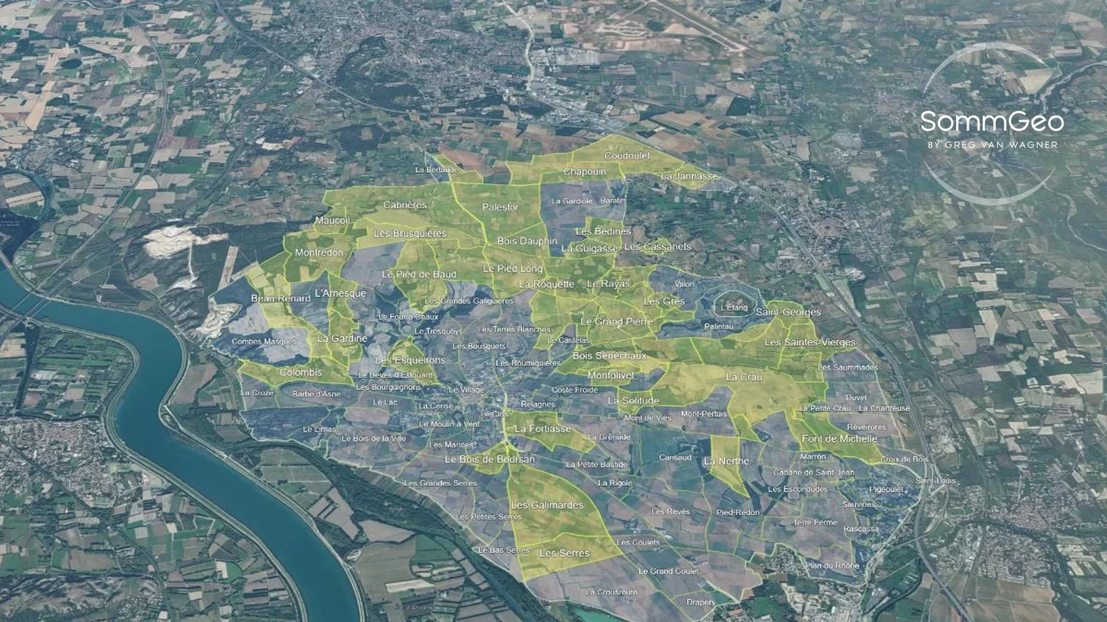
Châteauneuf-du-Pape takes its name from the castle built for Pope John XXII in the 14th century, and its ruin still stands above the village. The vineyards spread out from there across five communes, from Orange in the north to Sorgues in the south. Almost every bottle carries only the appellation name, so the lieux-dits underneath stay little known outside the region. On a flat map they are a puzzle of names. In 3D the pattern shows: the stony plateau of La Crau to the south-east, the Mont-Redon and Cabrières terrace to the north-west, the sandy sectors of Courthézon to the north-east, and the lower ground toward the Rhône. This map puts every lieu-dit into interactive terrain, each with its commune and site notes.
Unlock the Full SommGeo Toolkit
Gain exclusive access to our entire suite of premium features, including interactive Map Makers, immersive 3D Tours, high-resolution classic Maps, and advanced analytical tools.
Start Free TrialWhat You’ll Explore
This 3D Fast Map contains all 134 lieux-dits of Châteauneuf-du-Pape and the outline of the appellation. The best-documented lieux-dits are shaded gold as Top lieux-dits, and the key in the corner of the map tells the two groups apart. Click any lieu-dit for its profile: commune and, for the Top lieux-dits, site notes on soils and position. Search by name, including common alternate spellings such as Piedlong or Mont-Redon, to fly straight to a site. Use the elevation profile to compare the plateaus with the lower ground, and the daylight animation to watch the light move across the appellation.
- All 134 lieux-dits of Châteauneuf-du-Pape mapped individually
- The appellation outline across Châteauneuf-du-Pape, Courthézon, Bédarrides, Orange and Sorgues
- Top lieux-dits highlighted in gold, with a key on the map
- Search by lieu-dit or appellation, including alternate spellings
- Elevation profile tool for measuring vineyard altitude and slope gradients
- Daylight and shadow animation to visualize sun exposure across the appellation
Key Areas in Focus
La Crau, Mont-Redon and the Galets Plateaus
The rounded quartzite stones known as galets roulés are the picture most people have of Châteauneuf-du-Pape, yet the growers’ federation puts them on only about 500 hectares. The best known is La Crau, the stony plateau between the village and Bédarrides, where the galets cover red clay. The register splits it into four parts across three communes, merged here into one shape. North-west of the village, Cabrières and Montredon form the other great galets terrace. Cabrières, at about 217 hectares across Orange and Châteauneuf-du-Pape, is the largest lieu-dit on the map by delimited area. Between the two, Le Pied Long sits on the stony plateau north of the village. Tilt the map to see how these raised terraces stand above the ground around them.
The Sandy North-East and the Western Limestone
Sands, safres and sandstone are the largest soil group in the appellation, about 1,825 hectares according to the federation, mostly in the north and east. Much of that ground lies in the north-east of the appellation, on both sides of the Courthézon line, where Le Rayas, Pignan, Chapouin, Les Saintes-Vierges, La Guigasse and Les Bédines are all sandy sectors. Coudoulet sits on the north-eastern edge of the appellation, where the A7 motorway marks the limit. On the other side of the village, bare limestone runs for about 250 hectares along the western edge, toward the Rhône. La Fortiasse, just south-east of the village, was home to Baron Pierre Le Roy de Boiseaumarié, first president of the growers’ syndicate founded in 1923, whose push for production rules here fed into the French appellation system.
Lieux-dits on this map (134)
Every lieu-dit on the map, by commune, plus the appellation outline. The 3D map adds the terrain plus a profile for each.
| Lieu-dit | Commune |
|---|---|
| Châteauneuf-du-Pape (74 lieux-dits) | |
| L’Arnesque | Châteauneuf-du-Pape |
| Barbe d’Asne | Châteauneuf-du-Pape |
| Le Bas Serres | Châteauneuf-du-Pape |
| Beau Renard | Châteauneuf-du-Pape |
| La Bigote | Châteauneuf-du-Pape |
| Les Blaquières | Châteauneuf-du-Pape |
| Bois Sénéchaux | Châteauneuf-du-Pape |
| Le Bois de Boursan | Châteauneuf-du-Pape |
| Le Bois de la Ville | Châteauneuf-du-Pape |
| Le Boucoup | Châteauneuf-du-Pape |
| Les Bourguignons | Châteauneuf-du-Pape |
| Les Bousquets | Châteauneuf-du-Pape |
| Les Brusquières | Châteauneuf-du-Pape |
| Les Cabanes | Châteauneuf-du-Pape |
| Le Castelas | Châteauneuf-du-Pape |
| La Cerise | Châteauneuf-du-Pape |
| Charbonnières | Châteauneuf-du-Pape |
| Chemin de Courthézon | Châteauneuf-du-Pape |
| Le Chemin de Sorgues | Châteauneuf-du-Pape |
| Le Clos | Châteauneuf-du-Pape |
| Colombis | Châteauneuf-du-Pape |
| Combes Masques | Châteauneuf-du-Pape |
| Combes d’Arnavel | Châteauneuf-du-Pape |
| Coste Froide | Châteauneuf-du-Pape |
| Le Coteau de l’Ange | Châteauneuf-du-Pape |
| Les Coulets | Châteauneuf-du-Pape |
| La Croze | Châteauneuf-du-Pape |
| Le Devès d’Estouard | Châteauneuf-du-Pape |
| Les Esqueirons | Châteauneuf-du-Pape |
| Farguerol | Châteauneuf-du-Pape |
| La Font du Pape | Châteauneuf-du-Pape |
| La Fortiasse | Châteauneuf-du-Pape |
| Le Four à Chaux | Châteauneuf-du-Pape |
| Les Galimardes | Châteauneuf-du-Pape |
| La Gardine | Châteauneuf-du-Pape |
| Le Grand Chemin de Sorgues | Châteauneuf-du-Pape |
| Le Grand Devès | Châteauneuf-du-Pape |
| Le Grand Pierre | Châteauneuf-du-Pape |
| Les Grandes Galiguières | Châteauneuf-du-Pape |
| Les Grandes Serres | Châteauneuf-du-Pape |
| La Grenade | Châteauneuf-du-Pape |
| Le Lac | Châteauneuf-du-Pape |
| Le Limas | Châteauneuf-du-Pape |
| Marcoux | Châteauneuf-du-Pape |
| Les Marines | Châteauneuf-du-Pape |
| Les Mascaronnes | Châteauneuf-du-Pape |
| Mont de Viès | Châteauneuf-du-Pape |
| Mont-Pertuis | Châteauneuf-du-Pape |
| Montolivet | Châteauneuf-du-Pape |
| Montredon | Châteauneuf-du-Pape |
| Le Moulin à Vent | Châteauneuf-du-Pape |
| La Nerthe | Châteauneuf-du-Pape |
| Le Parc | Châteauneuf-du-Pape |
| Les Parrans | Châteauneuf-du-Pape |
| La Petite Bastide | Châteauneuf-du-Pape |
| Les Petites Serres | Châteauneuf-du-Pape |
| Le Pied Long | Châteauneuf-du-Pape |
| Le Pied de Baud | Châteauneuf-du-Pape |
| Pierre à Feu | Châteauneuf-du-Pape |
| Les Plagnes | Châteauneuf-du-Pape |
| Pradel | Châteauneuf-du-Pape |
| Puits Neuf | Châteauneuf-du-Pape |
| Relagnes | Châteauneuf-du-Pape |
| Les Revès | Châteauneuf-du-Pape |
| La Rigole | Châteauneuf-du-Pape |
| La Roquette | Châteauneuf-du-Pape |
| Les Roumiguières | Châteauneuf-du-Pape |
| Saint-Théodoric | Châteauneuf-du-Pape |
| Les Serres | Châteauneuf-du-Pape |
| La Solitude | Châteauneuf-du-Pape |
| Les Terres Blanches | Châteauneuf-du-Pape |
| Le Tresquoys | Châteauneuf-du-Pape |
| Vaudieu | Châteauneuf-du-Pape |
| Le Village | Châteauneuf-du-Pape |
| Bédarrides (23 lieux-dits) | |
| Cabane de Saint-Jean | Bédarrides |
| La Chartreuse | Bédarrides |
| Chemin de Châteauneuf | Bédarrides |
| Les Combes | Bédarrides |
| Coteau de Saint-Jean | Bédarrides |
| Le Coulaire | Bédarrides |
| Croix de Bois | Bédarrides |
| Duvet | Bédarrides |
| Les Escondudes | Bédarrides |
| Font de Michelle | Bédarrides |
| Les Garrigues | Bédarrides |
| Le Grand Plantier | Bédarrides |
| Marron | Bédarrides |
| Noffres | Bédarrides |
| Patouillet | Bédarrides |
| La Petite Crau | Bédarrides |
| Pigeoulet | Bédarrides |
| Plan du Rhône | Bédarrides |
| Rascassa | Bédarrides |
| Réveirores | Bédarrides |
| Saint-Louis | Bédarrides |
| Sauvines | Bédarrides |
| Terre Ferme | Bédarrides |
| Courthézon (22 lieux-dits) | |
| Baratin | Courthézon |
| Le Bousquet | Courthézon |
| Les Bédines | Courthézon |
| Les Cassanets | Courthézon |
| Chapouin | Courthézon |
| Coudoulet | Courthézon |
| Le Cristia | Courthézon |
| La Gardiole | Courthézon |
| Les Grès | Courthézon |
| La Guigasse | Courthézon |
| La Jannasse | Courthézon |
| Le Mourre de Gaud | Courthézon |
| Le Mourre des Perdrix | Courthézon |
| Palintau | Courthézon |
| Pignant | Courthézon |
| Le Pointu | Courthézon |
| Le Rayas | Courthézon |
| Saint-Georges | Courthézon |
| Les Saintes-Vierges | Courthézon |
| Les Saummades | Courthézon |
| Valori | Courthézon |
| L’Étang | Courthézon |
| Orange (5 lieux-dits) | |
| La Bertaude | Orange |
| Bois Dauphin | Orange |
| Bois Lauzon | Orange |
| Maucoil | Orange |
| Palestor | Orange |
| Sorgues (4 lieux-dits) | |
| La Crousroute | Sorgues |
| Drapery | Sorgues |
| Fangueiron | Sorgues |
| Le Grand Coulet | Sorgues |
| Across commune lines (6 lieux-dits) | |
| Cabrières | Orange, Châteauneuf-du-Pape |
| Cansaud | Châteauneuf-du-Pape, Bédarrides |
| La Crau | Courthézon, Bédarrides, Châteauneuf-du-Pape |
| La Font du Loup | Courthézon, Bédarrides |
| Pied-Redon | Châteauneuf-du-Pape, Bédarrides |
| Pignan | Courthézon, Châteauneuf-du-Pape |
| Appellation (1) | |
| Châteauneuf-du-Pape AOP | Châteauneuf-du-Pape, Courthézon, Bédarrides, Orange, Sorgues |
Hopefully this index is useful on its own. To explore these regions interactively, with every boundary on real terrain and a full profile for each, start a 15-day free trial. To see what one of these maps is like first, a different map is unlocked for everyone every day.
Châteauneuf-du-Pape 3D Wine Map: Frequently Asked Questions
How many lieux-dits are there in Châteauneuf-du-Pape?
This map shows 134. They come from the French land register, with the register’s Nord, Sud, Est and Ouest splits and a few spelling variants merged so that each name appears once. Seventy-four lie in the commune of Châteauneuf-du-Pape, 23 in Bédarrides, 22 in Courthézon, five in Orange and four in Sorgues, and six cross commune lines. The appellation rules set no ranking among them.
What grapes are allowed in Châteauneuf-du-Pape?
The rules list 18 varieties, or 13 by the traditional count that groups the color forms of the same grape. Grenache dominates the plantings, alongside Syrah, Mourvèdre and Cinsault, with Grenache Blanc, Clairette, Roussanne and Bourboulenc among the white varieties. Only still red and white wines carry the name, and red accounts for more than nine bottles in ten.
Is all of Châteauneuf-du-Pape covered in galets roulés?
No. The rounded stones are the famous image, but the growers’ federation puts galets roulés on about 500 hectares. Sands, safres and sandstone cover about 1,825 hectares, mostly in the north and east, recent alluvial terraces about 625, and bare limestone about 250 along the western edge. The 3D map lets you see where the stony plateaus of La Crau and Mont-Redon sit against the sandier ground of Courthézon.
What can the 3D map show that a flat map can’t?
Châteauneuf-du-Pape is gentler ground than the hills of the Northern Rhône, but the terrain still matters. You can tilt and rotate the map to see the raised plateaus and terraces, read elevation and slope with the profile tool, animate daylight and shadows, and add a weather overlay. For a flat view of the whole country, see the France Fast Map.
Is the Châteauneuf-du-Pape 3D wine map free?
The region index on this page is free to use. The interactive 3D map itself, with clickable boundaries and a full profile for every region, is part of SommGeo membership, which starts with a free 15-day trial. If you want a feel for what one of these maps is like before signing up, SommGeo unlocks one map every day on a rotation, different every day, no signup needed. Today’s unlocked map is on the home page.
New to 3D Fast Maps? Learn how to navigate 3D terrain, use elevation profiles, animate sunlight, and get the most from your map.
3D Fast Maps Guide →Ready to explore every lieu-dit of Châteauneuf-du-Pape in full 3D? Join 200+ wine organizations already using SommGeo.
Start Your 15-Day Free Trial $5/month billed annually after trial · Cancel anytimeMap Usage
Free for your own study and tastings. If you share or teach with a map, credit it visibly as Map: SommGeo (sommgeo.com). Commercial use requires a Commercial Embed License. See Map Usage, Credit and Licensing.
Map by Greg Van Wagner, SommGeo