Brunello di Montalcino 3D Wine Map: Eight Areas of One Hill on Real Terrain
The hill of Montalcino in eight unofficial areas, from Torrenieri and Castiglion del Bosco in the north to Sant’Angelo Scalo and Castelnuovo dell’Abate in the south, mapped on 3D terrain.
This interactive 3D map shows Brunello di Montalcino as eight unofficial areas on real terrain, inside the outline of the DOCG, drawn in 3D by SommGeo. Montalcino has no official subzones, so the areas are an unofficial division named for villages and hamlets, with approximate boundaries. Tilt and fly over the hill, check elevation and slope, and run the daylight and shadow animation to see which way each slope faces. Click any area for its profile. The interactive map is part of SommGeo membership, which starts with a free 15-day trial.
- On the map: 8 unofficial areas and the Brunello di Montalcino DOCG outline
- Grape: 100% Sangiovese
- Zone: The historic territory of the commune of Montalcino, about 40 kilometers (25 miles) south of Siena, bounded by the Ombrone, Orcia and Asso rivers
- Land: About 24,000 hectares (59,000 acres), of which roughly 2,100 hectares (5,200 acres) of vineyard are registered for Brunello
- Subzones: None official. The eight areas are an unofficial division with approximate boundaries
- 3D tools: Tilt and rotate the terrain, elevation and slope readouts, daylight and shadow animation and a weather overlay
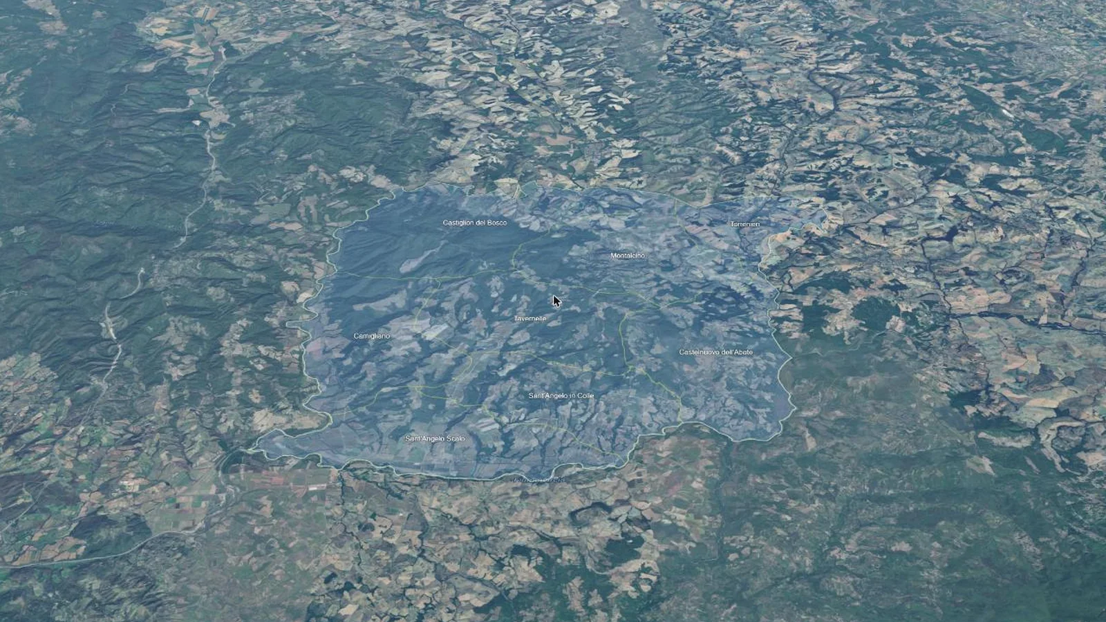
Brunello di Montalcino is a single, roughly square hill, and its vineyards run from about 120 m (390 ft) near the rivers to about 650 m (2,130 ft) near Poggio Civitella, the highest point of the commune. Monte Amiata, to the south, shelters the hill from storms and hail. On a flat map the hill is one shape. In 3D it is plain which areas hold the high ground around the town, which fall north toward cooler, lower country, and which drop south and west toward the Orcia and the Ombrone. This map puts the eight areas into interactive terrain, each with its own profile.
Unlock the Full SommGeo Toolkit
Gain exclusive access to our entire suite of premium features, including interactive Map Makers, immersive 3D Tours, high-resolution classic Maps, and advanced analytical tools.
Start Free TrialWhat You’ll Explore
This 3D Fast Map contains eight unofficial areas of Brunello di Montalcino plus the outline of the DOCG. Click any area for its profile: setting, elevation, soils and climate, and how it compares with the rest of the hill. Click the outline for the denomination’s rules. Search by area to fly straight to it. Use the elevation profile to measure a slope from river to ridge, and the daylight animation to compare how the northern and southern sides catch the sun.
- Eight unofficial areas of Brunello di Montalcino mapped individually
- The outline of the Brunello di Montalcino DOCG, with the denomination’s rules
- Search by area or appellation, with the map flying to the result
- Elevation profile tool for measuring vineyard altitude and slope gradients
- Daylight and shadow animation to visualize aspect and sun exposure by area
- A north-facing opening view of the whole denomination
Key Areas in Focus
The Town and the Northern Side
Montalcino takes in the hill town, at about 565 m (1,850 ft), and the slopes around it: the original core of Brunello production. Southeast of the town, vineyards sit at 400 to 500 m (1,310 to 1,640 ft) on infertile, calcareous soils. Torrenieri, the northeastern corner and the smallest of the eight areas by land area, is lower and heavier ground, with dense clays related to those of the neighboring Crete Senesi. Castiglion del Bosco covers the northwest and is the largest of the eight by land area, with thick woods around its vineyards. Its position on the northern side of the hill makes it one of the cooler parts of Montalcino. Fog and spring frost are risks in both northern areas.
The South and West
Tavernelle lies southwest of the town, with vineyards mostly at 300 to 350 m (980 to 1,150 ft), and on this map it also climbs toward the highest ground in the denomination by elevation, around Poggio Civitella. Camigliano is the hot, dry western side, falling from wooded hills toward the Ombrone. Sant’Angelo in Colle, a hill village at about 440 m (1,440 ft), faces Monte Amiata across the Orcia valley, well above Sant’Angelo Scalo, the lowest ground in Montalcino by elevation, where the Orcia meets the Ombrone. Castelnuovo dell’Abate covers the southeast, beside the abbey of Sant’Antimo, with vineyards between roughly 250 and 450 m (820 and 1,480 ft). Use the elevation profile to compare the two Sant’Angelo areas.
Regions on this map (9)
Every area on the map. The eight areas are unofficial and their boundaries are approximate. The 3D map adds the terrain plus a full profile for each.
| Region | Position or province |
|---|---|
| Unofficial areas (8) | |
| Montalcino | Center: the hill town and the slopes around it |
| Torrenieri | Northeast |
| Castiglion del Bosco | Northwest |
| Tavernelle | Southwest of the town |
| Camigliano | West |
| Sant’Angelo in Colle | South |
| Sant’Angelo Scalo | Southwest corner |
| Castelnuovo dell’Abate | Southeast |
| Appellation (1) | |
| Brunello di Montalcino DOCG | Province of Siena, Tuscany |
Hopefully this index is useful on its own. To explore these regions interactively, with every boundary on real terrain and a full profile for each, start a 15-day free trial. To see what one of these maps is like first, a different map is unlocked for everyone every day.
Brunello di Montalcino 3D Wine Map: Frequently Asked Questions
Does Brunello di Montalcino have official subzones?
No. The denomination covers the historic territory of the commune of Montalcino and has no official subzones. The eight areas on this map are an unofficial division named for villages and hamlets, and their boundaries are approximate.
What are the eight areas on this map?
Montalcino, Torrenieri, Castiglion del Bosco, Tavernelle, Camigliano, Sant’Angelo in Colle, Sant’Angelo Scalo and Castelnuovo dell’Abate. Each has its own profile on the map, and each profile says that the area is unofficial. The outline of the Brunello di Montalcino DOCG surrounds all eight.
What are the rules for Brunello di Montalcino?
Brunello is 100% Sangiovese. It spends at least two years in oak and four months in bottle, and may be released from January 1st of the fifth year after harvest. Riserva follows one year later and needs six months in bottle. The DOC dates from 1966 and the DOCG from 1980.
What can the 3D map show that a flat map can’t?
You can tilt and rotate the terrain, read elevation and slope gradients, animate daylight and shadows to see each area’s aspect and sun exposure, and add a weather overlay. For a flat view of the whole country, see the Italy Fast Map.
Is the Brunello di Montalcino 3D wine map free?
The region index on this page is free to use. The interactive 3D map itself, with clickable boundaries and a full profile for every region, is part of SommGeo membership, which starts with a free 15-day trial. If you want a feel for what one of these maps is like before signing up, SommGeo unlocks one map every day on a rotation, different every day, no signup needed. Today’s unlocked map is on the home page.
New to 3D Fast Maps? Learn how to navigate 3D terrain, use elevation profiles, animate sunlight, and get the most from your map.
3D Fast Maps Guide →Ready to explore the hill of Montalcino in full 3D? Join 200+ wine organizations already using SommGeo.
Start Your 15-Day Free Trial $5/month billed annually after trial · Cancel anytimeMap Usage
Free for your own study and tastings. If you share or teach with a map, credit it visibly as Map: SommGeo (sommgeo.com). Commercial use requires a Commercial Embed License. See Map Usage, Credit and Licensing.
Map by Greg Van Wagner, SommGeo