Southern Rhône Wine Map: All 20 AOPs in 3D, Interactive
Châteauneuf-du-Pape, Gigondas, Vacqueyras, and the Côtes du Rhône appellations in full 3D terrain.
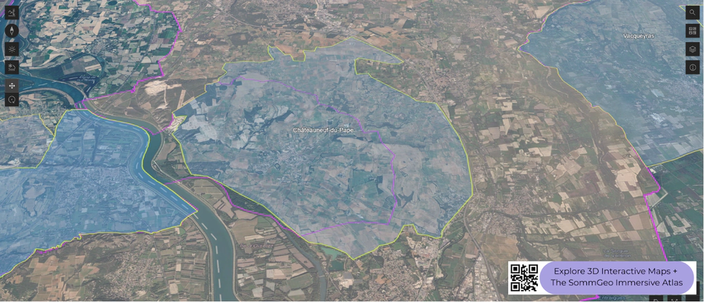
This interactive 3D Southern Rhône wine map shows all 20 AOPs on real terrain: Châteauneuf-du-Pape on its stony plateau, Gigondas, Vacqueyras and Beaumes de Venise under the Dentelles de Montmirail, Rasteau, Cairanne and Vinsobres in the hills to the north, Tavel and Lirac across the river, Ventoux and Luberon to the east, Costières de Nîmes and the Gard appellations to the west, and the Côtes du Rhône and Côtes du Rhône Villages that tie them together, drawn in 3D by SommGeo. Tilt and fly from the Dentelles to the Rhône, check elevation and slope, toggle the appellation layers, run the daylight animation and click any appellation for its grapes and rules. The interactive map is part of SommGeo membership, which starts with a free 15-day trial.
- Appellations on the map: All 20, every boundary clickable: 18 crus and local AOPs plus the Côtes du Rhône and Côtes du Rhône Villages that underlie them
- The pyramid: Côtes du Rhône at the base, Côtes du Rhône Villages above it, the Villages with a named commune above that, and the crus at the top, from Châteauneuf-du-Pape and Gigondas to Cairanne and Vinsobres
- Châteauneuf-du-Pape: A low plateau of galets roulés and red clay at about 80 to 130 meters (260 to 425 feet) above the river, with 13 permitted varieties, 18 counting colour variants, and Grenache usually leading the blend
- The Dentelles: A jagged limestone ridge above Gigondas, Vacqueyras and Beaumes de Venise, where the vineyards climb from the plain to the rock
- The mistral: The cold north wind that funnels down the valley, drying the vines and clearing the sky, and a reason growers across the region can farm with fewer treatments
- 3D tools: Tilt and rotate the terrain, elevation profile readouts, daylight and shadow animation and layer controls
The Southern Rhône is where the Rhône valley opens up. South of Montélimar, the narrow granite corridor of the north gives way to a broad, sun-drenched landscape shaped by the mistral, the Mediterranean, and the foothills of the Alps and the Dentelles de Montmirail. Grenache dominates here, supported by Syrah, Mourvèdre, Cinsault, and a long list of secondary varieties. The terrain is subtler than the Northern Rhône but no less important: the elevated plateau of Châteauneuf-du-Pape, the sheltered amphitheaters beneath the Dentelles, and the river terraces of the Côtes du Rhône all become readable in 3D in ways that flat maps cannot communicate.
Unlock the Full SommGeo Toolkit
Gain exclusive access to our entire suite of premium features, including interactive Map Makers, immersive 3D Tours, high-resolution classic Maps, and advanced analytical tools.
Start Free TrialWhat You’ll Explore
This 3D Fast Map covers the appellations of the Southern Rhône, from Châteauneuf-du-Pape and the Dentelles de Montmirail crus through the broader Côtes du Rhône and Côtes du Rhône-Villages. Click any mapped appellation for detailed popup content covering grape varieties, classification details, and geographic specifics. Use the layer controls to toggle different appellation groupings on and off.
- Full 3D terrain of Southern Rhône appellations
- Elevation profile tool for measuring vineyard altitude and slope gradients
- Daylight and shadow animation to visualize aspect and sun exposure
- Detailed popup data for every mapped appellation
Key Regions in Focus
Châteauneuf-du-Pape
The undisputed flagship of the Southern Rhône, Châteauneuf-du-Pape sits on an elevated plateau between the Rhône River and the village of Bédarrides. The appellation is famous for its galets roulés (large, rounded stones deposited by the ancient Rhône), which retain heat during the day and radiate it back to the vines at night. But the soil story is more complex than the stones suggest: the plateau includes areas of red clay, sand, and limestone that produce markedly different expressions of Grenache. Thirteen grape varieties are traditionally permitted in the blend (eighteen by the current INAO count, which lists color mutations separately), though Grenache typically dominates at 60% to 80%. The plateau sits at roughly 80 to 130 meters (260 to 425 feet) above sea level, and the slight elevation above the river plain is visible in the 3D terrain, as are the boundaries where the stony plateau gives way to sandier soils.
The Dentelles de Montmirail: Gigondas and Vacqueyras
East of Orange, the jagged limestone peaks of the Dentelles de Montmirail create a dramatic backdrop and a natural shelter for the vineyards at their base. Gigondas occupies the slopes surrounding these peaks, with vineyards on a wide range of exposures from south- and west-facing lower slopes to cooler north- and northwest-facing sites at higher elevations. The altitude and the sheltering effect of the Dentelles give Gigondas wines more structure and freshness than the warmer valley floor. Vacqueyras, just to the south, sits on slightly lower ground with more alluvial gravel and clay, producing slightly rustic wines. In 3D, the Dentelles are unmistakable: their serrated ridgeline and the way vineyards wrap around their lower slopes are among the most visually striking features in this map.
Côtes du Rhône-Villages and Named Crus
Beyond the headline appellations, the Southern Rhône includes a network of named villages and crus that have gained recognition in recent decades. Rasteau (elevated terraces, fortified Grenache tradition), Cairanne (limestone plateau, increasingly serious reds), Beaumes-de-Venise (famous for Muscat but also producing still reds), and Vinsobres (higher altitude, cooler nights) have all earned their own AOC status. The broader Côtes du Rhône and Côtes du Rhône-Villages appellations cover the valley floor and lower hillsides, where Grenache-based blends range from everyday drinking to genuinely serious wines depending on site and producer.
Appellations on this map (20)
Every AOP on the map: the two regional layers first, then the crus and local appellations. The 3D map adds the terrain, elevation and sun tools plus a full profile for each.
| Appellation | Principal grapes |
|---|---|
| Regional appellations | |
| Côtes du Rhône | Grenache, Syrah, Mourvèdre |
| Côtes du Rhône Villages | Grenache, Syrah, Mourvèdre |
| Crus and local appellations | |
| Châteauneuf-du-Pape | Grenache, Syrah, Mourvèdre, Cinsault, Counoise |
| Gigondas | Grenache, Syrah, Mourvèdre |
| Vacqueyras | Grenache, Syrah, Mourvèdre |
| Beaumes de Venise | Grenache, Syrah |
| Muscat de Beaumes-de-Venise | Muscat Blanc à Petits Grains |
| Rasteau | Grenache, Syrah, Mourvèdre |
| Cairanne | Grenache, Syrah, Mourvèdre, Roussanne |
| Vinsobres | Syrah, Mourvèdre, Grenache |
| Tavel | Grenache, Cinsault, Clairette |
| Lirac | Grenache, Syrah, Mourvèdre, Cinsault |
| Laudun | Grenache, Roussanne, Viognier |
| Ventoux | Grenache, Syrah, Mourvèdre, Carignan |
| Luberon | Syrah, Grenache, Mourvèdre, Vermentino |
| Grignan-les-Adhémar | Syrah, Grenache |
| Côtes du Vivarais | Syrah, Grenache, Marsanne |
| Duché d’Uzès | Syrah, Grenache, Viognier |
| Costières de Nîmes | Grenache, Syrah, Mourvèdre |
| Clairette de Bellegarde | Clairette |
Hopefully this index is useful on its own. To explore these regions interactively, with every boundary on real terrain and a full profile for each, start a 15-day free trial. To see what one of these maps is like first, a different map is unlocked for everyone every day. For a flat view of the same appellations, see the France Fast Map.
Southern Rhône 3D Wine Map: Frequently Asked Questions
What is the difference between Côtes du Rhône and Côtes du Rhône Villages?
They are two floors of the same pyramid. Côtes du Rhône is the regional appellation, covering a huge area on both banks from Vienne to Avignon, most of it in the south, with generous yields and a long list of grapes. Côtes du Rhône Villages is the next floor up, limited to the best communes of the south with lower yields and a higher share of Grenache, Syrah and Mourvèdre, and the best of those communes can add their own name to the label. The top floor is the crus, each with its own AOP: Châteauneuf-du-Pape, Gigondas, Vacqueyras, Beaumes de Venise, Vinsobres, Rasteau, Cairanne, Lirac and Tavel in the south, all drawn separately on this map.
What is the mistral?
A cold, dry north wind that pours down the Rhône corridor when high pressure sits over central France, often for days at a time and at more than 90 km/h (55 mph). It bends the trees of the southern Rhône permanently to the south, dries the vines after rain, which keeps rot away and lets growers farm with few treatments, and clears the sky so the sun is stronger than the latitude suggests. It also stresses the vines, thickening skins and concentrating the fruit, which is one reason southern Rhône reds are as dense as they are.
Why is Tavel only rosé?
Because its appellation rules say so: Tavel, on the right bank opposite Châteauneuf-du-Pape, is one of only two AOPs in France that make nothing but rosé, with Rosé des Riceys in the Aube the other. Grenache leads, with Cinsault, Clairette, Syrah and a handful of others, grown on three soils that show in the terrain: the sandy plateau, the galets roulés like those across the river, and the lauzes, flat limestone shards. The result is deeper in colour and fuller than most rosé, built to go with food and to age a little. Lirac, next door, makes the same blend in red, white and rosé.
What can the 3D map show that a flat map can’t?
You can tilt and rotate the terrain to see the Châteauneuf-du-Pape plateau standing above the river plain, the Dentelles de Montmirail rising behind Gigondas and Vacqueyras, the long slope of Mont Ventoux and the hills of Rasteau and Cairanne. The elevation profile reads the climb from the plain into the Dentelles, the daylight animation shows which slopes catch the sun, and the layer controls let you peel the crus away from the Côtes du Rhône beneath them. For a flat view of the same appellations, see the France Fast Map.
Is the Southern Rhône 3D wine map free?
The region index on this page is free to use. The interactive 3D map itself, with clickable boundaries and a full profile for every region, is part of SommGeo membership, which starts with a free 15-day trial. If you want a feel for what one of these maps is like before signing up, SommGeo unlocks one map every day on a rotation, different every day, no signup needed. Today’s unlocked map is on the home page.
New to 3D Fast Maps? Learn how to navigate 3D terrain, use elevation profiles, animate sunlight, and get the most from your map.
3D Fast Maps Guide →Ready to explore the Southern Rhône in full 3D? Join 200+ wine organizations already using SommGeo.
Start Your 15-Day Free Trial $5/month billed annually after trial · Cancel anytimeMap Usage
Free for your own study and tastings. If you share or teach with a map, credit it visibly as Map: SommGeo (sommgeo.com). Commercial use requires a Commercial Embed License. See Map Usage, Credit and Licensing.
Map by Greg Van Wagner, SommGeo