
US Wine Regions Map: 130 AVAs Beyond the West Coast in 3D
The Finger Lakes, Virginia, Texas, Lodi, and the emerging and established wine regions beyond the West Coast in full 3D terrain.
This interactive 3D United States wine map shows 130 AVAs on real terrain across 33 states, everything outside the North Coast, Central Coast, Columbia Valley and Willamette Valley, which have their own 3D maps: the Finger Lakes and Long Island, Virginia and the Blue Ridge, the Texas Hill Country and High Plains, Lodi and the Sierra Foothills, Michigan’s lake peninsulas, the Snake River Valley, Arizona, Colorado, New Mexico and the river valleys of the Midwest and the Ohio, drawn in 3D by SommGeo. Fly between regions with the bookmarks, check elevation and slope, run the daylight animation and click any AVA for its grapes and profile. The interactive map is part of SommGeo membership, which starts with a free 15-day trial.
- AVAs on the map: 130, every boundary clickable, from Long Island to Hawaii, 14 of them crossing state lines
- Biggest: Upper Mississippi River Valley (IA, IL, MN, WI) is the largest AVA in the country at about 29,900 square miles (77,400 sq km), with Ohio River Valley second and Texas Hill Country, at some 9 million acres, third
- Finger Lakes: Eleven glacial lakes; Seneca, over 600 feet (180 m) deep, almost never freezes and carries the best Riesling slopes at 800 to 1,000 feet (245 to 305 m)
- Texas: The High Plains at 3,000 to 4,000 feet (900 to 1,200 m) grows most of the state’s grapes; the Hill Country around Fredericksburg is where most of the wineries are
- Lodi and the Sierra Foothills: Lodi, with seven nested sub-AVAs, is California’s biggest source of Zinfandel; El Dorado, Fair Play, Fiddletown and North Yuba sit in the Sierra Foothills above it
- 3D tools: Tilt and rotate the terrain, bookmarks to fly between areas, elevation profile readouts, daylight and shadow animation and layer controls
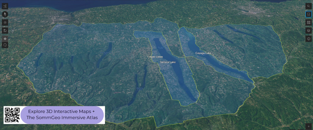
Wine is produced in all 50 states, but the regions that matter for sommeliers and serious professionals are scattered across the country in diverse and sometimes unexpected terrain. The Finger Lakes in upstate New York, the foothills of Virginia, the Texas Hill Country, and California’s Lodi each occupy distinct geographic niches with their own climate challenges and varietal strengths. This map brings these spread-out regions together with detailed popup data. The bookmarks are essential here: the regions on this map span thousands of miles, and the bookmarks will fly you directly between the Finger Lakes, Virginia, Texas, Lodi, and the other areas without manual scrolling across the continent. The layer controls let you change between shading and outlines.
Unlock the Full SommGeo Toolkit
Gain exclusive access to our entire suite of premium features, including interactive Map Makers, immersive 3D Tours, high-resolution classic Maps, and advanced analytical tools.
Start Free TrialWhat You’ll Explore
This 3D Fast Map covers the notable wine regions and AVAs across the United States outside of the North Coast, Central Coast, Columbia Valley, and Willamette Valley (which have their own dedicated maps). Click any mapped area for detailed popup content covering grape varieties, climate, and geographic specifics. The bookmarks are the way to navigate this map: the regions span the entire country, so use them to fly directly between the Finger Lakes, Virginia, Texas, Lodi, and other areas.
- Notable wine regions and AVAs across the USA mapped with detailed popup data
- Bookmarks to fly directly between the Finger Lakes, Virginia, Texas, Lodi, and more
- Elevation profile tool for measuring vineyard altitude and terrain gradients
- Daylight and shadow animation to visualize aspect and sun exposure
Key Regions in Focus
Finger Lakes, New York
The Finger Lakes is the most important cool-climate wine region in the eastern United States and one of the country’s best sources of Riesling. Eleven long, narrow, glacially carved lakes create a lake-effect microclimate that moderates the harsh continental conditions of upstate New York. Seneca Lake, the deepest at over 600 feet (183 m), never freezes and provides the most significant temperature moderation, with its best vineyards on steep slopes facing the water at 800 to 1,000 feet (245 to 305 m). Keuka Lake and Cayuga Lake add further variation. The 3D terrain makes the depth and scale of these glacial lakes visible, and the daylight animation shows how the lake-facing slopes catch different light throughout the day. Use the bookmarks to fly here from the other regions.
Virginia and the Mid-Atlantic
Virginia is one of the most established wine states on the East Coast and the fifth-largest by production. The primary growing areas sit in the Blue Ridge foothills at 500 to 1,500 feet (150 to 460 m), where elevation provides the drainage and air circulation needed in a humid climate. The Monticello AVA around Charlottesville is the best-known zone, producing Viognier (Virginia’s signature white), Cabernet Franc, and Petit Verdot on red clay and granite. The Shenandoah Valley, between the Blue Ridge and Alleghenies, offers slightly cooler conditions. Hillside vineyards with good air drainage outperform valley-floor sites significantly, and the terrain makes these distinctions visible. The bookmarks take you between Virginia and the other mapped states.
Texas, Lodi, and Other Regions
The Texas Hill Country AVA, west of Austin, is the third-largest AVA in the country by area, with vineyards on limestone and caliche at 1,000 to 2,000 feet (305 to 610 m). The Texas High Plains AVA around Lubbock, at roughly 3,300 feet (1,005 m), provides the altitude and diurnal swings that produce much of the state’s best fruit. Lodi, in California’s Central Valley, is one of the country’s most productive regions and the historic center of old-vine Zinfandel, with sandy loam soils moderated by the Sacramento Delta breeze. The map also covers regions in Michigan, Arizona, Colorado, and other states where the industry is growing. The bookmarks make it easy to jump between all of these across the full map.
AVAs on this map (130)
Every AVA on the map, by state, with multi-state AVAs at the end. The 3D map adds every boundary on real terrain plus a full profile for each.
| State | AVAs | Names on the map |
|---|---|---|
| Arizona | 3 | Sonoita, Verde Valley, Willcox |
| Arkansas | 2 | Altus, Arkansas Mountain |
| California | 48 | Alta Mesa, Antelope Valley of the California High Desert, Borden Ranch, California Shenandoah Valley, Capay Valley, Clarksburg, Clements Hills, Cosumnes River, Covelo, Cucamonga Valley, Diablo Grande, Dos Rios, Dunnigan Hills, El Dorado, Fair Play, Fiddletown, Inwood Valley, Jahant, Leona Valley, Lodi, Madera, Malibu Coast, Malibu-Newton Canyon, Manton Valley, Merritt Island, Mokelumne River, North Yuba, Palos Verdes Peninsula, Paulsell Valley, Ramona Valley, River Junction, Saddle Rock-Malibu, Salado Creek, San Luis Rey, San Pasqual Valley, Seiad Valley, Sierra Foothills, Sierra Pelona Valley, Sloughhouse, South Coast, Squaw Valley-Miramonte, Tehachapi Mountains, Temecula Valley, Tracy Hills, Trinity Lakes, Willow Creek, Winters Highlands, Yucaipa Valley |
| Colorado | 2 | Grand Valley, West Elks |
| Connecticut | 2 | Eastern Connecticut Highlands, Western Connecticut Highlands |
| Georgia | 1 | Dahlonega Plateau |
| Hawaii | 1 | Ulupalakua |
| Idaho | 1 | Eagle Foothills |
| Illinois | 1 | Shawnee Hills |
| Indiana | 1 | Indiana Uplands |
| Maryland | 2 | Catoctin, Linganore |
| Massachusetts | 1 | Martha’s Vineyard |
| Michigan | 5 | Fennville, Lake Michigan Shore, Leelanau Peninsula, Old Mission Peninsula, Tip of the Mitt |
| Minnesota | 1 | Alexandria Lakes |
| Missouri | 3 | Augusta, Hermann, Ozark Highlands |
| New Jersey | 3 | Cape May Peninsula, Outer Coastal Plain, Warren Hills |
| New Mexico | 2 | Middle Rio Grande Valley, Mimbres Valley |
| New York | 10 | Cayuga Lake, Champlain Valley of New York, Finger Lakes, Hudson River Region, Long Island, Niagara Escarpment, North Fork of Long Island, Seneca Lake, The Hamptons, Long Island, Upper Hudson |
| North Carolina | 4 | Crest of the Blue Ridge Henderson County, Haw River Valley, Swan Creek, Yadkin Valley |
| Ohio | 3 | Grand River Valley, Isle St. George, Loramie Creek |
| Pennsylvania | 2 | Lancaster Valley, Lehigh Valley |
| Tennessee | 1 | Upper Cumberland |
| Texas | 7 | Bell Mountain, Escondido Valley, Fredericksburg in the Texas Hill Country, Texas Davis Mountains, Texas High Plains, Texas Hill Country, Texoma |
| Virginia | 7 | Middleburg Virginia, Monticello, North Fork of Roanoke, Northern Neck George Washington Birthplace, Rocky Knob, Virginia Peninsula, Virginia’s Eastern Shore |
| West Virginia | 1 | Kanawha River Valley |
| Wisconsin | 2 | Lake Wisconsin, Wisconsin Ledge |
| Multi-state AVAs | 14 | Appalachian High Country (NC, TN, VA), Central Delaware Valley (PA, NJ), Cumberland Valley (MD, PA), Lake Erie (NY, OH, PA), Loess Hills District (IA, MO), Mesilla Valley (NM, TX), Mississippi Delta (MS, TN, LA), Ohio River Valley (IN, KY, OH, WV), Ozark Mountain (AR, MO, OK), Shenandoah Valley (VA, WV), Snake River Valley (ID, OR), Southeastern New England (CT, MA, RI), Upper Hiwassee Highlands (GA, NC), Upper Mississippi River Valley (IA, IL, MN, WI) |
Hopefully this index is useful on its own. To explore these regions interactively, with every boundary on real terrain and a full profile for each, start a 15-day free trial. To see what one of these maps is like first, a different map is unlocked for everyone every day. For a flat view of all 276 AVAs in one map, see the United States Fast Map.
Rest of USA 3D Wine Map: Frequently Asked Questions
Which US wine regions are on this map?
Everything that is not on SommGeo’s four West Coast 3D maps. That means New York’s Finger Lakes, Long Island and Hudson River; Virginia, Maryland and the Blue Ridge; the Carolinas and Georgia; the Texas Hill Country and High Plains; New Mexico and Arizona; Colorado’s Grand Valley; Michigan, Ohio, Missouri and the river-valley AVAs of the Midwest; the Snake River Valley of Idaho; the California AVAs outside the North and Central Coast, from Lodi and the Sierra Foothills to Temecula; and Hawaii’s Ulupalakua. 130 AVAs in all.
What is the largest AVA in the United States?
The Upper Mississippi River Valley, approved in 2009, which covers about 29,900 square miles (77,400 sq km) of Iowa, Illinois, Minnesota and Wisconsin along the river. It took the title from the Ohio River Valley, about 26,000 square miles (67,300 sq km) across Indiana, Kentucky, Ohio and West Virginia, and Texas Hill Country is third at roughly 9 million acres (3.6 million hectares). All three are on this map, and the bookmarks make the scale obvious: fly from the Finger Lakes to the Hill Country and the whole of New York’s wine country would fit inside one Texas AVA.
Why is the Finger Lakes good for Riesling?
Water and slope. The lakes are long, deep glacial troughs that store summer heat and release it through autumn, delaying the first frost, and in winter the deepest of them, Seneca and Cayuga, rarely freeze, so the air on the slopes above stays a few degrees milder than the countryside around. Vineyards face the water on shale and glacial soils, which drain well and hold the acidity Riesling needs. Seneca Lake and Cayuga Lake are nested AVAs inside the Finger Lakes AVA, and both are on this map.
What can the 3D map show that a flat map can’t?
You can tilt and rotate the terrain, use the bookmarks to fly from the Finger Lakes to Virginia, Texas and Lodi, read elevation and slope on the lake-facing hills of Seneca, the Blue Ridge above Monticello, the Caprock escarpment that lifts the Texas High Plains, and Colorado’s Grand Valley at about 4,500 feet (1,370 m), and animate daylight and shadows to see which slopes catch the sun. For a flat view of all 276 AVAs in one map, see the United States Fast Map.
Is the Rest of USA 3D wine map free?
The region index on this page is free to use. The interactive 3D map itself, with clickable boundaries and a full profile for every region, is part of SommGeo membership, which starts with a free 15-day trial. If you want a feel for what one of these maps is like before signing up, SommGeo unlocks one map every day on a rotation, different every day, no signup needed. Today’s unlocked map is on the home page.
New to 3D Fast Maps? Learn how to navigate 3D terrain, use elevation profiles, animate sunlight, and get the most from your map.
3D Fast Maps Guide →Ready to explore America’s wine regions in full 3D? Join 200+ wine organizations already using SommGeo.
Start Your 15-Day Free Trial $5/month billed annually after trial · Cancel anytimeMap Usage
Free for your own study and tastings. If you share or teach with a map, credit it visibly as Map: SommGeo (sommgeo.com). Commercial use requires a Commercial Embed License. See Map Usage, Credit and Licensing.
Map by Greg Van Wagner, SommGeo